![](/images/other/stat-length.png)
![Trail Walking Salernes - Salernes-St Barthélemy les Uchanes - Photo](https://media.geolcdn.com/t/1900/400/ext.pjpeg?maxdim=2&url=https%3A%2F%2Fstatic1.geolcdn.com%2Fsiteimages%2Fupload%2Ffiles%2F1553511878bg_sport_marche.png)
Salernes-St Barthélemy les Uchanes
Sugg
User
![Length](/images/other/stat-length.png)
Length
15.1 km
![Max alt](https://static1.geolcdn.com/siteimages/upload/files/1508320355ic_sort_altitude_max_24dp.png)
Max alt
501 m
![Uphill gradient](https://static1.geolcdn.com/siteimages/upload/files/1508320355ic_sort_den_pos_24dp.png)
Uphill gradient
241 m
![Km-Effort](/images/other/stat-length.png)
Km-Effort
18.3 km
![Min alt](https://static1.geolcdn.com/siteimages/upload/files/1508320355ic_sort_altitude_min_24dp.png)
Min alt
347 m
![Downhill gradient](https://static1.geolcdn.com/siteimages/upload/files/1508320355ic_sort_den_neg_24dp.png)
Downhill gradient
242 m
![Boucle](https://static1.geolcdn.com/siteimages/upload/files/16400158638029165_repeat_loop_refresh_sync_direction_icon.png)
Boucle
Yes
Creation date :
2019-03-22 16:58:54.249
Updated on :
2019-03-22 16:58:54.305
![Walking](https://static1.geolcdn.com/sitytour/trail-icons/101.png)
3h56
Difficulty : Easy
![Scan this QR Code to open this trail in the SityTrail application](https://capi.geolives.com/qq0zvz2zws4bq2lad0pu/sitytour/trails/696006/qr.png?size=200)
FREE GPS app for hiking
About
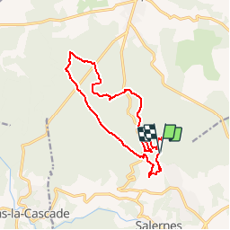
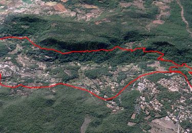
Trail Walking of 15.1 km to be discovered at Provence-Alpes-Côte d'Azur, Var, Salernes. This trail is proposed by Sugg.
Description
Parcours RF à reconnaître
Ce parcours sera raccourci le jour de la rando réelle ( 5 mars ) car mauvaise météo, soit de 478 à 478 !.
Positioning
Country:
France
Region :
Provence-Alpes-Côte d'Azur
Department/Province :
Var
Municipality :
Salernes
Location:
Unknown
Start:(Dec)
Start:(UTM)
276626 ; 4829410 (32T) N.
Comments
Trails nearby
![Trail Walking Sillans-la-Cascade - Trace_Sillans - Photo](https://media.geolcdn.com/t/375/260/4b45470f-3ffd-48ed-a237-4271c6a3710f.jpg&format=jpg&maxdim=2)
![Walking Walking](https://static1.geolcdn.com/sitytour/trail-icons/101.png)
Trace_Sillans
Walking
Medium
(1)
Sillans-la-Cascade,
Provence-Alpes-Côte d'Azur,
Var,
France
![](/images/other/stat-length.png)
15.1 km | 20 km-effort
6h 0min
![](https://static1.geolcdn.com/siteimages/upload/files/16400158638029165_repeat_loop_refresh_sync_direction_icon.png)
Yes
![Trail Walking Sillans-la-Cascade - 2024-03-05 La Bresque - Photo](https://media.geolcdn.com/t/375/260/c9038386-6b03-4f45-be3c-f8ce6bafb362.jpg&format=jpg&maxdim=2)
![Walking Walking](https://static1.geolcdn.com/sitytour/trail-icons/101.png)
2024-03-05 La Bresque
Walking
Easy
Sillans-la-Cascade,
Provence-Alpes-Côte d'Azur,
Var,
France
![](/images/other/stat-length.png)
15.1 km | 19 km-effort
4h 19min
![](https://static1.geolcdn.com/siteimages/upload/files/16400158638029165_repeat_loop_refresh_sync_direction_icon.png)
Yes
![Trail Walking Salernes - 2024-01-23 Salernes - Saint Barthélémy - Photo](https://media.geolcdn.com/t/375/260/cc5df783-866a-4bd9-89b4-172fc6b32819.jpg&format=jpg&maxdim=2)
![Walking Walking](https://static1.geolcdn.com/sitytour/trail-icons/101.png)
2024-01-23 Salernes - Saint Barthélémy
Walking
Difficult
Salernes,
Provence-Alpes-Côte d'Azur,
Var,
France
![](/images/other/stat-length.png)
11.2 km | 16.6 km-effort
3h 46min
![](https://static1.geolcdn.com/siteimages/upload/files/16400158638029165_repeat_loop_refresh_sync_direction_icon.png)
Yes
![Trail Walking Villecroze - 2023-10-31 Villecroz - Tourtour et tourisme - Photo](https://media.geolcdn.com/t/375/260/f84ff7d5-400b-494e-8808-c59b480ad1f2.jpg&format=jpg&maxdim=2)
![Walking Walking](https://static1.geolcdn.com/sitytour/trail-icons/101.png)
2023-10-31 Villecroz - Tourtour et tourisme
Walking
Medium
Villecroze,
Provence-Alpes-Côte d'Azur,
Var,
France
![](/images/other/stat-length.png)
17.6 km | 24 km-effort
5h 28min
![](https://static1.geolcdn.com/siteimages/upload/files/16400158638029165_repeat_loop_refresh_sync_direction_icon.png)
Yes
![Trail Walking Sillans-la-Cascade - 2023-10-22 La Bresque mystérieuse - Photo](https://media.geolcdn.com/t/375/260/ee8614e1-7a27-45d8-a32a-4b544fdb8d39.jpg&format=jpg&maxdim=2)
![Walking Walking](https://static1.geolcdn.com/sitytour/trail-icons/101.png)
2023-10-22 La Bresque mystérieuse
Walking
Difficult
Sillans-la-Cascade,
Provence-Alpes-Côte d'Azur,
Var,
France
![](/images/other/stat-length.png)
12.7 km | 16 km-effort
3h 38min
![](https://static1.geolcdn.com/siteimages/upload/files/16400158638029165_repeat_loop_refresh_sync_direction_icon.png)
Yes
![Trail Walking Villecroze - Villecroze de Chapelles en Grottes - Photo](https://media.geolcdn.com/t/375/260/b4f00218-714a-4329-ac66-fe1861cf789d.jpg&format=jpg&maxdim=2)
![Walking Walking](https://static1.geolcdn.com/sitytour/trail-icons/101.png)
Villecroze de Chapelles en Grottes
Walking
Very difficult
Villecroze,
Provence-Alpes-Côte d'Azur,
Var,
France
![](/images/other/stat-length.png)
19.9 km | 28 km-effort
5h 49min
![](https://static1.geolcdn.com/siteimages/upload/files/16400158638029165_repeat_loop_refresh_sync_direction_icon.png)
Yes
![Trail Walking Aups - 30-10-2022 Aups Sentier des Crêtes - Photo](https://media.geolcdn.com/t/375/260/032d8805-e093-4b3d-aca0-89dc5544919a.jpg&format=jpg&maxdim=2)
![Walking Walking](https://static1.geolcdn.com/sitytour/trail-icons/101.png)
30-10-2022 Aups Sentier des Crêtes
Walking
Medium
Aups,
Provence-Alpes-Côte d'Azur,
Var,
France
![](/images/other/stat-length.png)
20 km | 31 km-effort
5h 0min
![](https://static1.geolcdn.com/siteimages/upload/files/16400158638029165_repeat_loop_refresh_sync_direction_icon.png)
Yes
![Trail Walking Sillans-la-Cascade - 23-10-2022 Sillans La Cascade - Croix de Solliès - Salernes - Photo](https://media.geolcdn.com/t/375/260/e872b945-c289-4b77-8147-4bedd1cc41eb.jpg&format=jpg&maxdim=2)
![Walking Walking](https://static1.geolcdn.com/sitytour/trail-icons/101.png)
23-10-2022 Sillans La Cascade - Croix de Solliès - Salernes
Walking
Medium
Sillans-la-Cascade,
Provence-Alpes-Côte d'Azur,
Var,
France
![](/images/other/stat-length.png)
18.9 km | 26 km-effort
4h 40min
![](https://static1.geolcdn.com/siteimages/upload/files/16400158638029165_repeat_loop_refresh_sync_direction_icon.png)
Yes
![Trail Other activity Villecroze - fox - Photo](https://media.geolcdn.com/t/375/260/ext.jpg?maxdim=2&url=https%3A%2F%2Fstatic1.geolcdn.com%2Fsiteimages%2Fupload%2Ffiles%2F1545311037marcheuse_200dpi.jpg)
![Other activity Other activity](https://static1.geolcdn.com/sitytour/trail-icons/900.png)
fox
Other activity
Medium
(1)
Villecroze,
Provence-Alpes-Côte d'Azur,
Var,
France
![](/images/other/stat-length.png)
42 km | 52 km-effort
2h 24min
![](https://static1.geolcdn.com/siteimages/upload/files/16400158638029165_repeat_loop_refresh_sync_direction_icon.png)
Yes