Trail Walking Stavelot - Stavelot- Challes balade de la truite - Photo

Stavelot- Challes balade de la truite

 pgrodent
pgrodent

User

© OpenStreetMap contributors
Length
Length
10.3 km
Max alt
Max alt
428 m
Uphill gradient
Uphill gradient
230 m
Km-Effort
Km-Effort  
13.4 km
Min alt
Min alt
280 m
Downhill gradient
Downhill gradient
228 m
Boucle
Boucle
Yes
Creation date :
2014-12-10 00:00:00.0
Updated on :
2014-12-10 00:00:00.0

(3 Reviews)

Walking
Walking
--
Difficulty : Easy

Scan this QR Code to open this trail in the SityTrail application

FREE GPS app for hiking

Logo SityTrail SityTrail

IGN / Geographical institutes

Download SityTrail from the App Store Download SityTrail from Google Play

Logo SityTrail SityTrail World

The world is yours!

Download SityTrail from the App Store Download SityTrail from Google Play Download SityTrail on Huawei AppGallery

About

Trail Walking of 10.3 km to be discovered at Wallonia, Liège, Stavelot. This trail is proposed by pgrodent.

Elevation profile

Photos

Points of interest

Point of interest Stavelot - aire de repos - Photo
pgrodent
STAVELOT 

Positioning

Country:
Belgium
Region :
Wallonia
Department/Province :
Liège
Municipality :
Stavelot
Location:
Stavelot
Start:(UTM)
709488 ; 5586699 (31U) N.

Comments

Please log in to post a review or rate the element


Mooie wandeling, water,bos, dorp, aardeweg, asphalt...variatie genoeg. Bij nat weer voor waterdicht schoeisel aan trekken !


genial


Trails nearby

Trail Walking Trois-Ponts - RB-Lg-29_Wanne - Photo
Walking
PRO

Walking

(5)
Trois-Ponts, Wallonia, Liège, Belgium
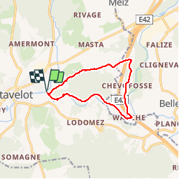
22 km | 29 km-effort
6h 41min
Yes
Trail Walking Stavelot - 2021-06-30_12h14m27_stavelot_13km_new - Photo
Walking
GUIDE
mumu.larandonneuse

Walking

Medium
(2)
Stavelot, Wallonia, Liège, Belgium
13.4 km | 19.8 km-effort
4h 30min
Yes
Trail Walking Stavelot - 2021-03-10_14h59m08_1227 - Photo
Walking
GUIDE
mumu.larandonneuse

Walking

Difficult
(3)
Stavelot, Wallonia, Liège, Belgium
18.8 km | 26 km-effort
5h 53min
No
Trail Walking Malmedy - RB-LG-09 - Sur les hauteurs dominant la haute vallée de l’Amblève et la Warche - Photo
Walking
PRO

Walking

Medium
(4)
Malmedy, Wallonia, Liège, Belgium
26 km | 34 km-effort
7h 12min
Yes
Trail Walking Stavelot - Chemin des Sources |stage 3 STAVELOT - HOCKAI - Photo
Walking
PRO

Walking

Very difficult
(1)
Stavelot, Wallonia, Liège, Belgium
19 km | 25 km-effort
5h 45min
No
Trail On foot Malmedy - Brasserie de Bellevaux - Photo
On foot
PRO

On foot

Easy
(3)
Malmedy, Wallonia, Liège, Belgium
10.2 km | 13.1 km-effort
4h 0min
Yes
Trail Trail Stavelot - Extratrail - Stavelot (red) 23km - Photo
Trail
PRO

Trail

Very difficult
(1)
Stavelot, Wallonia, Liège, Belgium
23 km | 35 km-effort
Unknown
Yes
Trail Trail Stavelot - Extra Trail - Stavelot (blue) 13km - Photo
Trail
PRO

Trail

Difficult
(1)
Stavelot, Wallonia, Liège, Belgium
13.4 km | 19.5 km-effort
Unknown
Yes
Trail Trail Stavelot - Extratrail - Stavelot (green) 9km - Photo
Trail
PRO

Trail

Medium
(1)
Stavelot, Wallonia, Liège, Belgium
10.1 km | 13.9 km-effort
Unknown
Yes


Close
My subscriptions