


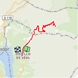

13.1 km | 26 km-effort


User


FREE GPS app for hiking
 SityTrail
IGN / Geographical institutes
SityTrail World
The world is yours!
Trail Snowshoes of 8.5 km to be discovered at Occitania, Pyrénées-Orientales, Réal. This trail is proposed by jpipacific.
rando jolie et pas trop dure. Magnifique vue depuis le refuge Oller. Non gardé mais ouvert. A chacun de le laisser impeccable après passage.

Snowshoes

Walking

Walking

Snowshoes

Walking
Snowshoes
Walking

Snowshoes

Mountain bike