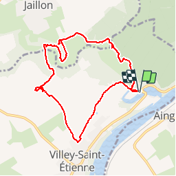
![](/images/other/stat-length.png)
![Trail Walking Villey-Saint-Étienne - Villey st Etienne - Photo](https://media.geolcdn.com/t/1900/400/ext.pjpeg?maxdim=2&url=https%3A%2F%2Fservices.sitytrail.com%2FGeolivesWS%2FDownloadMedia.ashx%3FTrailID%3D689892%26Media%3D20170126161830.jpg)
Villey st Etienne
australys
User
![Length](/images/other/stat-length.png)
![Max alt](https://static1.geolcdn.com/siteimages/upload/files/1508320355ic_sort_altitude_max_24dp.png)
![Uphill gradient](https://static1.geolcdn.com/siteimages/upload/files/1508320355ic_sort_den_pos_24dp.png)
![Km-Effort](/images/other/stat-length.png)
![Min alt](https://static1.geolcdn.com/siteimages/upload/files/1508320355ic_sort_altitude_min_24dp.png)
![Downhill gradient](https://static1.geolcdn.com/siteimages/upload/files/1508320355ic_sort_den_neg_24dp.png)
![Boucle](https://static1.geolcdn.com/siteimages/upload/files/16400158638029165_repeat_loop_refresh_sync_direction_icon.png)
![Walking](https://static1.geolcdn.com/sitytour/trail-icons/101.png)
2h20
Difficulty : Easy
![Scan this QR Code to open this trail in the SityTrail application](https://capi.geolives.com/qq0zvz2zws4bq2lad0pu/sitytour/trails/689892/qr.png?size=200)
FREE GPS app for hiking
About
Trail Walking of 8.9 km to be discovered at Grand Est, Meurthe-et-Moselle, Villey-Saint-Étienne. This trail is proposed by australys.
Description
Balade sympa autour de Villey- saint- Etienne et Jaillon.
Le Terrouin sinue dans une vallée étroite total de 24 kilomètres. Les Communes concernées sont Trondes, Lagney, Sanzey, Ménil la Tour, Andilly, Manoncourt en Woëvre, Avrainville, Jaillon et Villey St Etienne
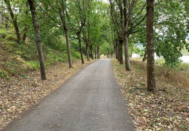
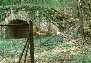
vallée sauvage et préservée, castor d’Europe, chat sauvage, martin-pêcheur, héron cendré, grenouille verte et rainette, couleuvre à collier…
Milieux naturels : zones humides, anciennes carrières, pelouses calcaire
, bonne balade.
Positioning
Comments
Trails nearby
![Trail Walking Liverdun - Liverdun - La grande boucle de Natrou - Photo](https://media.geolcdn.com/t/375/260/5dac390e-3606-42c9-8130-3aab112c0eaf.jpg&format=jpg&maxdim=2)
![Walking Walking](https://static1.geolcdn.com/sitytour/trail-icons/101.png)
Walking
![](/images/other/stat-length.png)
![](https://static1.geolcdn.com/siteimages/upload/files/16400158638029165_repeat_loop_refresh_sync_direction_icon.png)
![Trail On foot Jaillon - Circuit de Jaillon - Photo](https://media.geolcdn.com/t/375/260/2676c367-543f-4a9f-9348-cc04c26dbf9c.jpeg&format=jpg&maxdim=2)
![On foot On foot](https://static1.geolcdn.com/sitytour/trail-icons/100.png)
On foot
![](/images/other/stat-length.png)
![](https://static1.geolcdn.com/siteimages/upload/files/16400158638029165_repeat_loop_refresh_sync_direction_icon.png)
![Trail On foot Jaillon - Sentier de découverte de la vallée du Terrouin - Photo](https://media.geolcdn.com/t/375/260/6e52721f-5d1e-4b30-b153-0ca1b0f0f7e0.jpeg&format=jpg&maxdim=2)
![On foot On foot](https://static1.geolcdn.com/sitytour/trail-icons/100.png)
On foot
![](/images/other/stat-length.png)
![](https://static1.geolcdn.com/siteimages/upload/files/16400158638029165_repeat_loop_refresh_sync_direction_icon.png)
![Trail Road bike Liverdun - 2020 09 03 Nancy par voie vélo - Photo](https://media.geolcdn.com/t/375/260/c3ac8dd3-f654-4ba5-8ff7-ab3c7408e6de.jpg&format=jpg&maxdim=2)
![Road bike Road bike](https://static1.geolcdn.com/sitytour/trail-icons/201.png)
Road bike
![](/images/other/stat-length.png)
![](https://static1.geolcdn.com/siteimages/upload/files/16400158638029165_repeat_loop_refresh_sync_direction_icon.png)
![Trail Walking Toul - TOUL - LA CROIX D'ARGENT - Photo](https://media.geolcdn.com/t/375/260/e3f1b75b-7d57-4344-812a-03d7abcb3a24.jpg&format=jpg&maxdim=2)
![Walking Walking](https://static1.geolcdn.com/sitytour/trail-icons/101.png)
Walking
![](/images/other/stat-length.png)
![](https://static1.geolcdn.com/siteimages/upload/files/16400158638029165_repeat_loop_refresh_sync_direction_icon.png)
![Trail Walking Villey-Saint-Étienne - Villette st etienne - Photo](https://media.geolcdn.com/t/375/260/2352cc63-2e96-489a-8cbc-64ad8b8f96c9.jpg&format=jpg&maxdim=2)
![Walking Walking](https://static1.geolcdn.com/sitytour/trail-icons/101.png)
Walking
![](/images/other/stat-length.png)
![](https://static1.geolcdn.com/siteimages/upload/files/16400158638029165_repeat_loop_refresh_sync_direction_icon.png)
![Trail Walking Liverdun - foret de Natrou & vallée de la Moselle avec barrage de la Marne au Rhin avec l écluse - Photo](https://media.geolcdn.com/t/375/260/ext.jpg?maxdim=2&url=https%3A%2F%2Fservices.sitytrail.com%2FGeolivesWS%2FDownloadMedia.ashx%3FTrailID%3D688485%26Media%3D20170123164830.jpg)
![Walking Walking](https://static1.geolcdn.com/sitytour/trail-icons/101.png)
Walking
![](/images/other/stat-length.png)
![](https://static1.geolcdn.com/siteimages/upload/files/16400158638029165_repeat_loop_refresh_sync_direction_icon.png)
![Trail Walking Fontenoy-sur-Moselle - Fontenoy Bois Essarte - Photo](https://media.geolcdn.com/t/375/260/4359d1d1-83dd-4b3d-af28-6cc3aecfbb92.jpg&format=jpg&maxdim=2)
![Walking Walking](https://static1.geolcdn.com/sitytour/trail-icons/101.png)
Walking
![](/images/other/stat-length.png)
![](https://static1.geolcdn.com/siteimages/upload/files/16400158638029165_repeat_loop_refresh_sync_direction_icon.png)
![Trail On foot Villey-Saint-Étienne - Circuit Sous les charmes du Vieux Canton - Photo](https://media.geolcdn.com/t/375/260/51bd65e3-ea13-47ab-ac3b-5cb9d4a6128a.jpeg&format=jpg&maxdim=2)
![On foot On foot](https://static1.geolcdn.com/sitytour/trail-icons/100.png)
On foot
![](/images/other/stat-length.png)
![](https://static1.geolcdn.com/siteimages/upload/files/16400158638029165_repeat_loop_refresh_sync_direction_icon.png)