![](/images/other/stat-length.png)
![Trail Walking Le Tampon - Boucle trous blancs - Photo](https://media.geolcdn.com/t/1900/400/ext.pjpeg?maxdim=2&url=https%3A%2F%2Fstatic1.geolcdn.com%2Fsiteimages%2Fupload%2Ffiles%2F1553511878bg_sport_marche.png)
Boucle trous blancs
Fdum
User
![Length](/images/other/stat-length.png)
Length
3.9 km
![Max alt](https://static1.geolcdn.com/siteimages/upload/files/1508320355ic_sort_altitude_max_24dp.png)
Max alt
2021 m
![Uphill gradient](https://static1.geolcdn.com/siteimages/upload/files/1508320355ic_sort_den_pos_24dp.png)
Uphill gradient
182 m
![Km-Effort](/images/other/stat-length.png)
Km-Effort
6.3 km
![Min alt](https://static1.geolcdn.com/siteimages/upload/files/1508320355ic_sort_altitude_min_24dp.png)
Min alt
1836 m
![Downhill gradient](https://static1.geolcdn.com/siteimages/upload/files/1508320355ic_sort_den_neg_24dp.png)
Downhill gradient
179 m
![Boucle](https://static1.geolcdn.com/siteimages/upload/files/16400158638029165_repeat_loop_refresh_sync_direction_icon.png)
Boucle
Yes
Creation date :
2017-01-22 00:00:00.0
Updated on :
2017-01-22 00:00:00.0
![Walking](https://static1.geolcdn.com/sitytour/trail-icons/101.png)
1h15
Difficulty : Very easy
![Scan this QR Code to open this trail in the SityTrail application](https://capi.geolives.com/qq0zvz2zws4bq2lad0pu/sitytour/trails/687742/qr.png?size=200)
FREE GPS app for hiking
About
Trail Walking of 3.9 km to be discovered at Réunion, Unknown, Le Tampon. This trail is proposed by Fdum.
Description
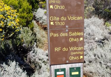
Très facile. Vous pouvez vous garer un peu plus haut sur le chemin. Il y a beaucoup de tables pour le pique nique. De même vous pouvez descendre dans le deuxième trou, en direction de piton sec... A vos GPS
Positioning
Country:
France
Region :
Réunion
Department/Province :
Unknown
Municipality :
Le Tampon
Location:
Unknown
Start:(Dec)
Start:(UTM)
355298 ; 7654776 (40K) S.
Comments
Trails nearby
![Trail Walking Saint-Joseph - Morne Langevin - Photo](https://media.geolcdn.com/t/375/260/4a48cc84-a345-4e59-a26e-9ebfc18443b6.jpg&format=jpg&maxdim=2)
![Walking Walking](https://static1.geolcdn.com/sitytour/trail-icons/101.png)
Morne Langevin
Walking
Easy
Saint-Joseph,
Réunion,
Unknown,
France
![](/images/other/stat-length.png)
10.7 km | 14.4 km-effort
2h 43min
![](https://static1.geolcdn.com/siteimages/upload/files/16400158638029165_repeat_loop_refresh_sync_direction_icon.png)
Yes
![Trail Walking Le Tampon - Piton de l'eau par le Rempart de la Rivière de l'Est - Photo](https://media.geolcdn.com/t/375/260/ccd7d241-7acf-406b-b558-3fd236979d1f.jpg&format=jpg&maxdim=2)
![Walking Walking](https://static1.geolcdn.com/sitytour/trail-icons/101.png)
Piton de l'eau par le Rempart de la Rivière de l'Est
Walking
Medium
Le Tampon,
Réunion,
Unknown,
France
![](/images/other/stat-length.png)
18.4 km | 27 km-effort
5h 0min
![](https://static1.geolcdn.com/siteimages/upload/files/16400158638029165_repeat_loop_refresh_sync_direction_icon.png)
Yes
![Trail On foot Le Tampon - 3 pitons à Bourg Murat - Photo](https://media.geolcdn.com/t/375/260/970bad91-7bf9-4096-b52f-d8b7555be2f2.jpg&format=jpg&maxdim=2)
![On foot On foot](https://static1.geolcdn.com/sitytour/trail-icons/100.png)
3 pitons à Bourg Murat
On foot
Medium
Le Tampon,
Réunion,
Unknown,
France
![](/images/other/stat-length.png)
12.4 km | 16.4 km-effort
Unknown
![](https://static1.geolcdn.com/siteimages/upload/files/16400158638029165_repeat_loop_refresh_sync_direction_icon.png)
Yes
![Trail Walking Le Tampon - bourg murat la fournaise - Photo](https://media.geolcdn.com/t/375/260/90df9966-627c-4173-ae45-ca4957fd7ec0.jpg&format=jpg&maxdim=2)
![Walking Walking](https://static1.geolcdn.com/sitytour/trail-icons/101.png)
bourg murat la fournaise
Walking
Difficult
Le Tampon,
Réunion,
Unknown,
France
![](/images/other/stat-length.png)
19.1 km | 29 km-effort
7h 38min
![](https://static1.geolcdn.com/siteimages/upload/files/16400158638029165_repeat_loop_refresh_sync_direction_icon.png)
No
![Trail Walking Saint-Joseph - Boucle autour de la plaine des sables - Photo](https://media.geolcdn.com/t/375/260/c4eaba1a-2561-47f6-8299-57d93e516a4a.jpg&format=jpg&maxdim=2)
![Walking Walking](https://static1.geolcdn.com/sitytour/trail-icons/101.png)
Boucle autour de la plaine des sables
Walking
Difficult
Saint-Joseph,
Réunion,
Unknown,
France
![](/images/other/stat-length.png)
16.2 km | 21 km-effort
4h 49min
![](https://static1.geolcdn.com/siteimages/upload/files/16400158638029165_repeat_loop_refresh_sync_direction_icon.png)
Yes
![Trail Walking Saint-Joseph - La Réunion - Retour - Ravine Citron Galet par le nez de Boeufs - Photo](https://media.geolcdn.com/t/375/260/ext.jpg?maxdim=2&url=https%3A%2F%2Fservices.sitytrail.com%2FGeolivesWS%2FDownloadMedia.ashx%3FTrailID%3D636153%26Media%3Dfix__20160925140435.jpg)
![Walking Walking](https://static1.geolcdn.com/sitytour/trail-icons/101.png)
La Réunion - Retour - Ravine Citron Galet par le nez de Boeufs
Walking
Medium
Saint-Joseph,
Réunion,
Unknown,
France
![](/images/other/stat-length.png)
8.4 km | 24 km-effort
2h 9min
![](https://static1.geolcdn.com/siteimages/upload/files/16400158638029165_repeat_loop_refresh_sync_direction_icon.png)
Yes
![Trail Walking Le Tampon - Murat nez de bœuf - Photo](https://media.geolcdn.com/t/375/260/ext.jpg?maxdim=2&url=https%3A%2F%2Fstatic1.geolcdn.com%2Fsiteimages%2Fupload%2Ffiles%2F1553511878bg_sport_marche.png)
![Walking Walking](https://static1.geolcdn.com/sitytour/trail-icons/101.png)
Murat nez de bœuf
Walking
Very easy
(1)
Le Tampon,
Réunion,
Unknown,
France
![](/images/other/stat-length.png)
15.9 km | 23 km-effort
5h 23min
![](https://static1.geolcdn.com/siteimages/upload/files/16400158638029165_repeat_loop_refresh_sync_direction_icon.png)
Yes
![Trail Walking Le Tampon - Trous Blancs de Piton Sec - Photo](https://media.geolcdn.com/t/375/260/ext.jpg?maxdim=2&url=https%3A%2F%2Fservices.sitytrail.com%2FGeolivesWS%2FDownloadMedia.ashx%3FTrailID%3D452656%26Media%3Dfix__20150730105930.jpg)
![Walking Walking](https://static1.geolcdn.com/sitytour/trail-icons/101.png)
Trous Blancs de Piton Sec
Walking
Easy
(1)
Le Tampon,
Réunion,
Unknown,
France
![](/images/other/stat-length.png)
3.9 km | 6.1 km-effort
3h 4min
![](https://static1.geolcdn.com/siteimages/upload/files/16400158638029165_repeat_loop_refresh_sync_direction_icon.png)
Yes
![Trail Walking Saint-Joseph - La Réunion - Boucle de la Plaine des sables par l'Oratoire Sainte-Thérèse - Photo](https://media.geolcdn.com/t/375/260/ext.jpg?maxdim=2&url=https%3A%2F%2Fservices.sitytrail.com%2FGeolivesWS%2FDownloadMedia.ashx%3FTrailID%3D403539%26Media%3Dfix__20150404122807.jpg)
![Walking Walking](https://static1.geolcdn.com/sitytour/trail-icons/101.png)
La Réunion - Boucle de la Plaine des sables par l'Oratoire Sainte-Thérèse
Walking
Medium
Saint-Joseph,
Réunion,
Unknown,
France
![](/images/other/stat-length.png)
15.8 km | 21 km-effort
5h 40min
![](https://static1.geolcdn.com/siteimages/upload/files/16400158638029165_repeat_loop_refresh_sync_direction_icon.png)
Yes