![](/images/other/stat-length.png)
![Trail Walking Hondarribia/Fontarrabie - 4 Sentier littoral au départ d'Ermita Guadalupe - Photo](https://media.geolcdn.com/t/1900/400/ext.pjpeg?maxdim=2&url=https%3A%2F%2Fservices.sitytrail.com%2FGeolivesWS%2FDownloadMedia.ashx%3FTrailID%3D685609%26Media%3Dfix__20141013135929.jpg)
4 Sentier littoral au départ d'Ermita Guadalupe
DECHAMPD
User
![Length](/images/other/stat-length.png)
Length
14.6 km
![Max alt](https://static1.geolcdn.com/siteimages/upload/files/1508320355ic_sort_altitude_max_24dp.png)
Max alt
294 m
![Uphill gradient](https://static1.geolcdn.com/siteimages/upload/files/1508320355ic_sort_den_pos_24dp.png)
Uphill gradient
467 m
![Km-Effort](/images/other/stat-length.png)
Km-Effort
21 km
![Min alt](https://static1.geolcdn.com/siteimages/upload/files/1508320355ic_sort_altitude_min_24dp.png)
Min alt
6 m
![Downhill gradient](https://static1.geolcdn.com/siteimages/upload/files/1508320355ic_sort_den_neg_24dp.png)
Downhill gradient
462 m
![Boucle](https://static1.geolcdn.com/siteimages/upload/files/16400158638029165_repeat_loop_refresh_sync_direction_icon.png)
Boucle
Yes
Creation date :
2019-01-14 17:31:02.684
Updated on :
2022-01-27 16:20:04.286
![Walking](https://static1.geolcdn.com/sitytour/trail-icons/101.png)
4h21
Difficulty : Easy
![Scan this QR Code to open this trail in the SityTrail application](https://capi.geolives.com/qq0zvz2zws4bq2lad0pu/sitytour/trails/685609/qr.png?size=200)
FREE GPS app for hiking
About
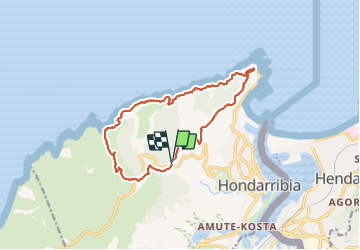
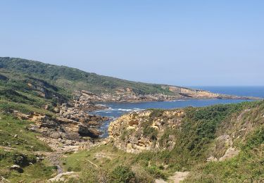
Trail Walking of 14.6 km to be discovered at Autonomous Community of the Basque Country, Gipuzkoa, Hondarribia/Fontarrabie. This trail is proposed by DECHAMPD.
Description
au départ d'Ermita Guadalupe par Cabo de Higuer, Plantainaudi, Marla, Txurtxipi, Laondo Munandi,
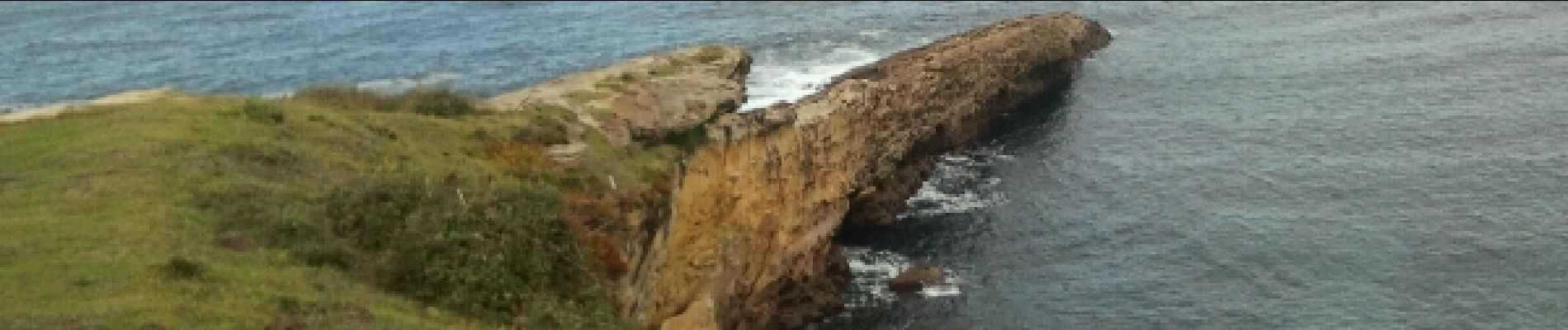
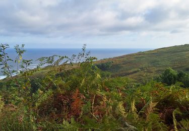
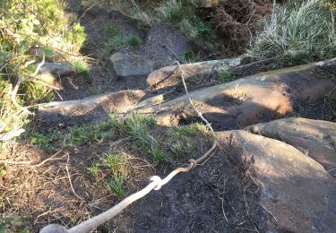
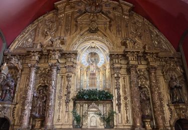
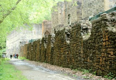
Positioning
Country:
Spain
Region :
Autonomous Community of the Basque Country
Department/Province :
Gipuzkoa
Municipality :
Hondarribia/Fontarrabie
Location:
Unknown
Start:(Dec)
Start:(UTM)
595497 ; 4802382 (30T) N.
Comments
Trails nearby
![Trail Walking Hondarribia/Fontarrabie - roro - Photo](https://media.geolcdn.com/t/375/260/ext.jpg?maxdim=2&url=https%3A%2F%2Fstatic1.geolcdn.com%2Fsiteimages%2Fupload%2Ffiles%2F1553511878bg_sport_marche.png)
![Walking Walking](https://static1.geolcdn.com/sitytour/trail-icons/101.png)
roro
Walking
Very easy
(1)
Hondarribia/Fontarrabie,
Autonomous Community of the Basque Country,
Gipuzkoa,
Spain
![](/images/other/stat-length.png)
21 km | 31 km-effort
9h 10min
![](https://static1.geolcdn.com/siteimages/upload/files/16400158638029165_repeat_loop_refresh_sync_direction_icon.png)
No
![Trail Walking Hondarribia/Fontarrabie - Jaizkibel - Chemin côtier - Cap du Figuier - Notre-Dame de Guadalupe - Photo](https://media.geolcdn.com/t/375/260/ext.jpg?maxdim=2&url=https%3A%2F%2Fstatic1.geolcdn.com%2Fsiteimages%2Fupload%2Ffiles%2F1553511878bg_sport_marche.png)
![Walking Walking](https://static1.geolcdn.com/sitytour/trail-icons/101.png)
Jaizkibel - Chemin côtier - Cap du Figuier - Notre-Dame de Guadalupe
Walking
Very easy
(3)
Hondarribia/Fontarrabie,
Autonomous Community of the Basque Country,
Gipuzkoa,
Spain
![](/images/other/stat-length.png)
13.7 km | 18.9 km-effort
3h 59min
![](https://static1.geolcdn.com/siteimages/upload/files/16400158638029165_repeat_loop_refresh_sync_direction_icon.png)
Yes
![Trail Walking Irun - Ibarla - Cascade d'Aitzondo - Ermitage san Martzial 2024 01 21 - Photo](https://media.geolcdn.com/t/375/260/ext.jpg?maxdim=2&url=https%3A%2F%2Fservices.sitytrail.com%2FGeolivesWS%2FDownloadMedia.ashx%3FTrailID%3D530456%26Media%3Dfix__20160226111436.jpg)
![Walking Walking](https://static1.geolcdn.com/sitytour/trail-icons/101.png)
Ibarla - Cascade d'Aitzondo - Ermitage san Martzial 2024 01 21
Walking
Very difficult
Irun,
Autonomous Community of the Basque Country,
Gipuzkoa,
Spain
![](/images/other/stat-length.png)
12.1 km | 19.7 km-effort
4h 28min
![](https://static1.geolcdn.com/siteimages/upload/files/16400158638029165_repeat_loop_refresh_sync_direction_icon.png)
Yes
![Trail Walking Hondarribia/Fontarrabie - Pasaia les vallées des couleurs - Photo](https://media.geolcdn.com/t/375/260/57f480d6-c56c-4ebd-ac8e-5bd675485a93.jpg&format=jpg&maxdim=2)
![Walking Walking](https://static1.geolcdn.com/sitytour/trail-icons/101.png)
Pasaia les vallées des couleurs
Walking
Difficult
Hondarribia/Fontarrabie,
Autonomous Community of the Basque Country,
Gipuzkoa,
Spain
![](/images/other/stat-length.png)
11.9 km | 18 km-effort
4h 34min
![](https://static1.geolcdn.com/siteimages/upload/files/16400158638029165_repeat_loop_refresh_sync_direction_icon.png)
Yes
![Walking Walking](https://static1.geolcdn.com/sitytour/trail-icons/101.png)
littoral Jaizkibel, vallée des couleurs et Paramondras
Walking
Very difficult
Hondarribia/Fontarrabie,
Autonomous Community of the Basque Country,
Gipuzkoa,
Spain
![](/images/other/stat-length.png)
12.8 km | 22 km-effort
5h 6min
![](https://static1.geolcdn.com/siteimages/upload/files/16400158638029165_repeat_loop_refresh_sync_direction_icon.png)
Yes
![Trail Walking Hondarribia/Fontarrabie - Fondarrabie sentier côtier bis - Photo](https://media.geolcdn.com/t/375/260/499622ed-279c-4bc8-a410-ec9c09f4d2c1.jpg&format=jpg&maxdim=2)
![Walking Walking](https://static1.geolcdn.com/sitytour/trail-icons/101.png)
Fondarrabie sentier côtier bis
Walking
Easy
Hondarribia/Fontarrabie,
Autonomous Community of the Basque Country,
Gipuzkoa,
Spain
![](/images/other/stat-length.png)
13.1 km | 18 km-effort
3h 56min
![](https://static1.geolcdn.com/siteimages/upload/files/16400158638029165_repeat_loop_refresh_sync_direction_icon.png)
Yes
![Trail On foot Irun - SL-GI 1006 Cascada de Aitzondo - Photo](https://media.geolcdn.com/t/375/260/949c10e2-10b5-4598-a875-2bd7cf386c52.jpeg&format=jpg&maxdim=2)
![On foot On foot](https://static1.geolcdn.com/sitytour/trail-icons/100.png)
SL-GI 1006 Cascada de Aitzondo
On foot
Easy
Irun,
Autonomous Community of the Basque Country,
Gipuzkoa,
Spain
![](/images/other/stat-length.png)
6 km | 8.4 km-effort
1h 54min
![](https://static1.geolcdn.com/siteimages/upload/files/16400158638029165_repeat_loop_refresh_sync_direction_icon.png)
Yes
![Trail Walking Hondarribia/Fontarrabie - hondarribia cap figuier - Photo](https://media.geolcdn.com/t/375/260/ace45812-18e3-4fc6-bc81-bbde70a3189c.jpg&format=jpg&maxdim=2)
![Walking Walking](https://static1.geolcdn.com/sitytour/trail-icons/101.png)
hondarribia cap figuier
Walking
Medium
Hondarribia/Fontarrabie,
Autonomous Community of the Basque Country,
Gipuzkoa,
Spain
![](/images/other/stat-length.png)
15.1 km | 21 km-effort
5h 15min
![](https://static1.geolcdn.com/siteimages/upload/files/16400158638029165_repeat_loop_refresh_sync_direction_icon.png)
Yes
![Trail Walking Irun - Ibarla - Cascade d'Aitzondo - Ermitage san Martzial 2020 01 21 - Photo](https://media.geolcdn.com/t/375/260/ext.jpg?maxdim=2&url=https%3A%2F%2Fservices.sitytrail.com%2FGeolivesWS%2FDownloadMedia.ashx%3FTrailID%3D530456%26Media%3Dfix__20160226111436.jpg)
![Walking Walking](https://static1.geolcdn.com/sitytour/trail-icons/101.png)
Ibarla - Cascade d'Aitzondo - Ermitage san Martzial 2020 01 21
Walking
Irun,
Autonomous Community of the Basque Country,
Gipuzkoa,
Spain
![](/images/other/stat-length.png)
13 km | 21 km-effort
5h 4min
![](https://static1.geolcdn.com/siteimages/upload/files/16400158638029165_repeat_loop_refresh_sync_direction_icon.png)
Yes