![](/images/other/stat-length.png)
![Trail Walking Autichamp - Autichamp Vieux Roynac - Photo](https://media.geolcdn.com/t/1900/400/ext.pjpeg?maxdim=2&url=https%3A%2F%2Fstatic1.geolcdn.com%2Fsiteimages%2Fupload%2Ffiles%2F1553511878bg_sport_marche.png)
Autichamp Vieux Roynac
collot
User
![Length](/images/other/stat-length.png)
Length
18.7 km
![Max alt](https://static1.geolcdn.com/siteimages/upload/files/1508320355ic_sort_altitude_max_24dp.png)
Max alt
481 m
![Uphill gradient](https://static1.geolcdn.com/siteimages/upload/files/1508320355ic_sort_den_pos_24dp.png)
Uphill gradient
632 m
![Km-Effort](/images/other/stat-length.png)
Km-Effort
27 km
![Min alt](https://static1.geolcdn.com/siteimages/upload/files/1508320355ic_sort_altitude_min_24dp.png)
Min alt
223 m
![Downhill gradient](https://static1.geolcdn.com/siteimages/upload/files/1508320355ic_sort_den_neg_24dp.png)
Downhill gradient
634 m
![Boucle](https://static1.geolcdn.com/siteimages/upload/files/16400158638029165_repeat_loop_refresh_sync_direction_icon.png)
Boucle
Yes
Creation date :
2017-01-16 00:00:00.0
Updated on :
2017-01-16 00:00:00.0
![Walking](https://static1.geolcdn.com/sitytour/trail-icons/101.png)
6h56
Difficulty : Difficult
![Scan this QR Code to open this trail in the SityTrail application](https://capi.geolives.com/qq0zvz2zws4bq2lad0pu/sitytour/trails/684837/qr.png?size=200)
FREE GPS app for hiking
About
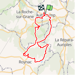
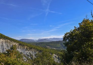
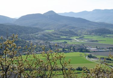
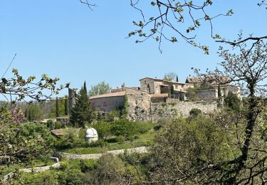
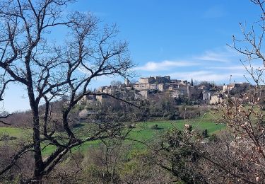
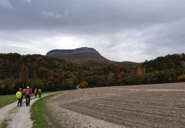
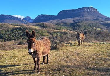
Trail Walking of 18.7 km to be discovered at Auvergne-Rhône-Alpes, Drôme, Autichamp. This trail is proposed by collot.
Description
AltiCampus>.fr nous a fourni l'idée de la rando.
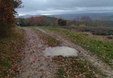
Rando moyenne, pas entretenue ! Et pas mal de goudron.
Le vieux Roynac ne mérite pas forcément la visite !
Positioning
Country:
France
Region :
Auvergne-Rhône-Alpes
Department/Province :
Drôme
Municipality :
Autichamp
Location:
Unknown
Start:(Dec)
Start:(UTM)
655684 ; 4949532 (31T) N.
Comments
Trails nearby
![Trail Walking Roynac - 2022-10-20_15h11m02_GPX-Baron-Chevriere-Roynac - Photo](https://media.geolcdn.com/t/375/260/391c3607-7246-4503-ab3c-b0a2bdd942e1.jpg&format=jpg&maxdim=2)
![Walking Walking](https://static1.geolcdn.com/sitytour/trail-icons/101.png)
2022-10-20_15h11m02_GPX-Baron-Chevriere-Roynac
Walking
Difficult
Roynac,
Auvergne-Rhône-Alpes,
Drôme,
France
![](/images/other/stat-length.png)
10.6 km | 15.7 km-effort
3h 34min
![](https://static1.geolcdn.com/siteimages/upload/files/16400158638029165_repeat_loop_refresh_sync_direction_icon.png)
Yes
![Trail Walking Puy-Saint-Martin - La Montagne de Ste-Euphémie - Puy-St-Martin - Manas - Photo](https://media.geolcdn.com/t/375/260/9ffa099d-cee9-4899-ad83-53e5ecd5907c.jpg&format=jpg&maxdim=2)
![Walking Walking](https://static1.geolcdn.com/sitytour/trail-icons/101.png)
La Montagne de Ste-Euphémie - Puy-St-Martin - Manas
Walking
Medium
Puy-Saint-Martin,
Auvergne-Rhône-Alpes,
Drôme,
France
![](/images/other/stat-length.png)
14.4 km | 22 km-effort
5h 5min
![](https://static1.geolcdn.com/siteimages/upload/files/16400158638029165_repeat_loop_refresh_sync_direction_icon.png)
Yes
![Trail sport La Roche-sur-Grane - La Roche Sur Grane Pierre sanglante - Photo](https://media.geolcdn.com/t/375/260/00a75b30-e9f2-4ffa-8db5-87cf804557d7.jpg&format=jpg&maxdim=2)
La Roche Sur Grane Pierre sanglante
sport
Very easy
La Roche-sur-Grane,
Auvergne-Rhône-Alpes,
Drôme,
France
![](/images/other/stat-length.png)
13 km | 17 km-effort
Unknown
![](https://static1.geolcdn.com/siteimages/upload/files/16400158638029165_repeat_loop_refresh_sync_direction_icon.png)
Yes
![Trail Walking Autichamp - Autichamp 9Km - Photo](https://media.geolcdn.com/t/375/260/277bf4ea-4835-4fdb-8282-6e16b9963cce.jpg&format=jpg&maxdim=2)
![Walking Walking](https://static1.geolcdn.com/sitytour/trail-icons/101.png)
Autichamp 9Km
Walking
Difficult
(1)
Autichamp,
Auvergne-Rhône-Alpes,
Drôme,
France
![](/images/other/stat-length.png)
8.8 km | 13.2 km-effort
2h 59min
![](https://static1.geolcdn.com/siteimages/upload/files/16400158638029165_repeat_loop_refresh_sync_direction_icon.png)
Yes
![Trail Walking Autichamp - 2022-06-24_19h04m17_Autichamp 16km.gpx.xml - Photo](https://media.geolcdn.com/t/375/260/ff500e8d-e5ee-4913-9cc9-1d2f8dd43576.jpg&format=jpg&maxdim=2)
![Walking Walking](https://static1.geolcdn.com/sitytour/trail-icons/101.png)
2022-06-24_19h04m17_Autichamp 16km.gpx.xml
Walking
Very difficult
Autichamp,
Auvergne-Rhône-Alpes,
Drôme,
France
![](/images/other/stat-length.png)
16.3 km | 23 km-effort
5h 9min
![](https://static1.geolcdn.com/siteimages/upload/files/16400158638029165_repeat_loop_refresh_sync_direction_icon.png)
Yes
![Trail Walking Crest - crest vierge divajeu hubat aouste - Photo](https://media.geolcdn.com/t/375/260/ee289172-6359-4811-9efa-2c8394fcdbfd.jpg&format=jpg&maxdim=2)
![Walking Walking](https://static1.geolcdn.com/sitytour/trail-icons/101.png)
crest vierge divajeu hubat aouste
Walking
Easy
Crest,
Auvergne-Rhône-Alpes,
Drôme,
France
![](/images/other/stat-length.png)
16.5 km | 24 km-effort
6h 10min
![](https://static1.geolcdn.com/siteimages/upload/files/16400158638029165_repeat_loop_refresh_sync_direction_icon.png)
Yes
![Trail Mountain bike Crest - pas de lauzun vtt - Photo](https://media.geolcdn.com/t/375/260/ext.jpg?maxdim=2&url=https%3A%2F%2Fstatic1.geolcdn.com%2Fsiteimages%2Fupload%2Ffiles%2F1524743154velo.jpg)
![Mountain bike Mountain bike](https://static1.geolcdn.com/sitytour/trail-icons/202.png)
pas de lauzun vtt
Mountain bike
Very easy
(1)
Crest,
Auvergne-Rhône-Alpes,
Drôme,
France
![](/images/other/stat-length.png)
17.4 km | 23 km-effort
Unknown
![](https://static1.geolcdn.com/siteimages/upload/files/16400158638029165_repeat_loop_refresh_sync_direction_icon.png)
Yes
![Trail Walking Crest - crest divajeu - Photo](https://media.geolcdn.com/t/375/260/cf010178-53b5-4440-b31b-9f59a793c8ce.jpg&format=jpg&maxdim=2)
![Walking Walking](https://static1.geolcdn.com/sitytour/trail-icons/101.png)
crest divajeu
Walking
Easy
Crest,
Auvergne-Rhône-Alpes,
Drôme,
France
![](/images/other/stat-length.png)
13.6 km | 18.4 km-effort
4h 6min
![](https://static1.geolcdn.com/siteimages/upload/files/16400158638029165_repeat_loop_refresh_sync_direction_icon.png)
Yes
![Trail Walking Crest - 26 crest zel 14.12.23 pluie - Photo](https://media.geolcdn.com/t/375/260/ee61d6f5-508d-4f7f-95f6-a723cb8051ec.jpg&format=jpg&maxdim=2)
![Walking Walking](https://static1.geolcdn.com/sitytour/trail-icons/101.png)
26 crest zel 14.12.23 pluie
Walking
Easy
Crest,
Auvergne-Rhône-Alpes,
Drôme,
France
![](/images/other/stat-length.png)
17.2 km | 24 km-effort
6h 20min
![](https://static1.geolcdn.com/siteimages/upload/files/16400158638029165_repeat_loop_refresh_sync_direction_icon.png)
Yes