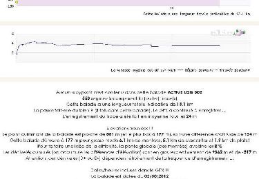
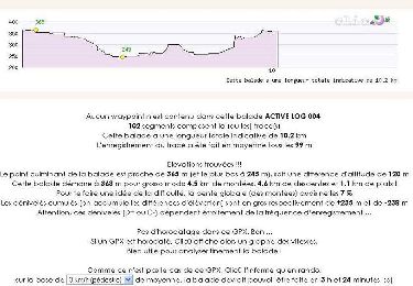
![](/images/other/stat-length.png)
![Trail Walking Lézat-sur-Lèze - Moulins Lézat - Photo](https://media.geolcdn.com/t/1900/400/ext.pjpeg?maxdim=2&url=https%3A%2F%2Fstatic1.geolcdn.com%2Fsiteimages%2Fupload%2Ffiles%2F1553511878bg_sport_marche.png)
Moulins Lézat
pidjam
User
![Length](/images/other/stat-length.png)
Length
8.8 km
![Max alt](https://static1.geolcdn.com/siteimages/upload/files/1508320355ic_sort_altitude_max_24dp.png)
Max alt
308 m
![Uphill gradient](https://static1.geolcdn.com/siteimages/upload/files/1508320355ic_sort_den_pos_24dp.png)
Uphill gradient
140 m
![Km-Effort](/images/other/stat-length.png)
Km-Effort
10.7 km
![Min alt](https://static1.geolcdn.com/siteimages/upload/files/1508320355ic_sort_altitude_min_24dp.png)
Min alt
207 m
![Downhill gradient](https://static1.geolcdn.com/siteimages/upload/files/1508320355ic_sort_den_neg_24dp.png)
Downhill gradient
140 m
![Boucle](https://static1.geolcdn.com/siteimages/upload/files/16400158638029165_repeat_loop_refresh_sync_direction_icon.png)
Boucle
Yes
Creation date :
2017-01-12 00:00:00.0
Updated on :
2017-01-12 00:00:00.0
![Walking](https://static1.geolcdn.com/sitytour/trail-icons/101.png)
1h57
Difficulty : Easy
![Scan this QR Code to open this trail in the SityTrail application](https://capi.geolives.com/qq0zvz2zws4bq2lad0pu/sitytour/trails/682975/qr.png?size=200)
FREE GPS app for hiking
About
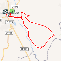
Trail Walking of 8.8 km to be discovered at Occitania, Ariège, Lézat-sur-Lèze. This trail is proposed by pidjam.
Description
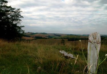
Petite rando vers les moulins de Lézat (première section à vérifier pour le passage du coté du "château", sinon elle ne ferait que 7.5km. parcours en cours de validation)
Positioning
Country:
France
Region :
Occitania
Department/Province :
Ariège
Municipality :
Lézat-sur-Lèze
Location:
Unknown
Start:(Dec)
Start:(UTM)
365919 ; 4792696 (31T) N.
Comments
Trails nearby
![Trail Walking Latrape - Latrape - Photo](https://media.geolcdn.com/t/375/260/ext.jpg?maxdim=2&url=https%3A%2F%2Fservices.sitytrail.com%2FGeolivesWS%2FDownloadMedia.ashx%3FTrailID%3D695682%26Media%3Df4e58813-a7a8-42ca-87be-2c32be993f8b.JPG)
![Walking Walking](https://static1.geolcdn.com/sitytour/trail-icons/101.png)
![Trail Walking Saint-Ybars - Balade à Saint Ybars - Photo](https://media.geolcdn.com/t/375/260/ext.jpg?maxdim=2&url=https%3A%2F%2Fservices.sitytrail.com%2FGeolivesWS%2FDownloadMedia.ashx%3FTrailID%3D118763%26Media%3D12960_2.jpg)
![Walking Walking](https://static1.geolcdn.com/sitytour/trail-icons/101.png)
Balade à Saint Ybars
Walking
Medium
Saint-Ybars,
Occitania,
Ariège,
France
![](/images/other/stat-length.png)
13.1 km | 16.7 km-effort
4h 0min
![](https://static1.geolcdn.com/siteimages/upload/files/16400158638029165_repeat_loop_refresh_sync_direction_icon.png)
Yes
![Trail Equestrian Lézat-sur-Lèze - Lézat sur Lèze - Saint Ybard - Photo](https://media.geolcdn.com/t/375/260/ext.jpg?maxdim=2&url=https%3A%2F%2Fservices.sitytrail.com%2FGeolivesWS%2FDownloadMedia.ashx%3FTrailID%3D108223%26Media%3D861_1.jpg)
![Equestrian Equestrian](https://static1.geolcdn.com/sitytour/trail-icons/300.png)
Lézat sur Lèze - Saint Ybard
Equestrian
Medium
Lézat-sur-Lèze,
Occitania,
Ariège,
France
![](/images/other/stat-length.png)
9.1 km | 11.9 km-effort
1h 0min
![](https://static1.geolcdn.com/siteimages/upload/files/16400158638029165_repeat_loop_refresh_sync_direction_icon.png)
No
![Trail Walking Latrape - Boucle de Latrape - Photo](https://media.geolcdn.com/t/375/260/ext.jpg?maxdim=2&url=https%3A%2F%2Fservices.sitytrail.com%2FGeolivesWS%2FDownloadMedia.ashx%3FTrailID%3D107673%26Media%3D12678_2.jpg)
![Walking Walking](https://static1.geolcdn.com/sitytour/trail-icons/101.png)
Boucle de Latrape
Walking
Medium
Latrape,
Occitania,
Haute-Garonne,
France
![](/images/other/stat-length.png)
10.2 km | 12.8 km-effort
3h 0min
![](https://static1.geolcdn.com/siteimages/upload/files/16400158638029165_repeat_loop_refresh_sync_direction_icon.png)
Yes
![Trail Walking Latrape - Grand tour de Latrape - Photo](https://media.geolcdn.com/t/375/260/ext.jpg?maxdim=2&url=https%3A%2F%2Fservices.sitytrail.com%2FGeolivesWS%2FDownloadMedia.ashx%3FTrailID%3D103181%26Media%3D5008_1.jpg)
![Walking Walking](https://static1.geolcdn.com/sitytour/trail-icons/101.png)
Grand tour de Latrape
Walking
Medium
Latrape,
Occitania,
Haute-Garonne,
France
![](/images/other/stat-length.png)
9.2 km | 11.5 km-effort
3h 0min
![](https://static1.geolcdn.com/siteimages/upload/files/16400158638029165_repeat_loop_refresh_sync_direction_icon.png)
Yes
![Trail Walking Latrape - De Latrape au Cap del Bose - Photo](https://media.geolcdn.com/t/375/260/ext.jpg?maxdim=2&url=https%3A%2F%2Fservices.sitytrail.com%2FGeolivesWS%2FDownloadMedia.ashx%3FTrailID%3D103180%26Media%3D5007_1.jpg)
![Walking Walking](https://static1.geolcdn.com/sitytour/trail-icons/101.png)
De Latrape au Cap del Bose
Walking
Medium
Latrape,
Occitania,
Haute-Garonne,
France
![](/images/other/stat-length.png)
6.4 km | 8.1 km-effort
2h 45min
![](https://static1.geolcdn.com/siteimages/upload/files/16400158638029165_repeat_loop_refresh_sync_direction_icon.png)
Yes
![Trail Walking Latrape - De Latrape à l'Aunat - Photo](https://media.geolcdn.com/t/375/260/ext.jpg?maxdim=2&url=https%3A%2F%2Fservices.sitytrail.com%2FGeolivesWS%2FDownloadMedia.ashx%3FTrailID%3D103179%26Media%3D5006_1.jpg)
![Walking Walking](https://static1.geolcdn.com/sitytour/trail-icons/101.png)
De Latrape à l'Aunat
Walking
Medium
Latrape,
Occitania,
Haute-Garonne,
France
![](/images/other/stat-length.png)
7.2 km | 9.4 km-effort
2h 0min
![](https://static1.geolcdn.com/siteimages/upload/files/16400158638029165_repeat_loop_refresh_sync_direction_icon.png)
Yes
![Trail Walking Latrape - De Latrape au château de Mailholas - Photo](https://media.geolcdn.com/t/375/260/ext.jpg?maxdim=2&url=https%3A%2F%2Fservices.sitytrail.com%2FGeolivesWS%2FDownloadMedia.ashx%3FTrailID%3D103178%26Media%3D5005_1.jpg)
![Walking Walking](https://static1.geolcdn.com/sitytour/trail-icons/101.png)
De Latrape au château de Mailholas
Walking
Medium
Latrape,
Occitania,
Haute-Garonne,
France
![](/images/other/stat-length.png)
8.7 km | 11.4 km-effort
2h 30min
![](https://static1.geolcdn.com/siteimages/upload/files/16400158638029165_repeat_loop_refresh_sync_direction_icon.png)
Yes
![Trail Walking Latrape - De Latrape à Règue Longue - Photo](https://media.geolcdn.com/t/375/260/ext.jpg?maxdim=2&url=https%3A%2F%2Fservices.sitytrail.com%2FGeolivesWS%2FDownloadMedia.ashx%3FTrailID%3D103136%26Media%3D4923_1.jpg)
![Walking Walking](https://static1.geolcdn.com/sitytour/trail-icons/101.png)
De Latrape à Règue Longue
Walking
Easy
Latrape,
Occitania,
Haute-Garonne,
France
![](/images/other/stat-length.png)
7.3 km | 9.9 km-effort
1h 30min
![](https://static1.geolcdn.com/siteimages/upload/files/16400158638029165_repeat_loop_refresh_sync_direction_icon.png)
Yes