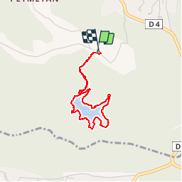
17.3 km | 26 km-effort
Le lac du Rioutard court
Sugg
User
Length
3.3 km
Max alt
313 m
Uphill gradient
73 m
Km-Effort
4.3 km
Min alt
253 m
Downhill gradient
69 m
Boucle
Yes
Creation date :
2019-03-22 16:58:58.744
Updated on :
2019-03-22 16:58:58.817
55m
Difficulty : Very easy
FREE GPS app for hiking
About
Trail Walking of 3.3 km to be discovered at Provence-Alpes-Côte d'Azur, Var, Saint-Paul-en-Forêt. This trail is proposed by Sugg.
Description
080117 balade avec my Wife
Positioning
Country:
France
Region :
Provence-Alpes-Côte d'Azur
Department/Province :
Var
Municipality :
Saint-Paul-en-Forêt
Location:
Unknown
Start:(Dec)
Start:(UTM)
313393 ; 4825590 (32T) N.
Comments
Trails nearby
Pic du Castel Diaou - Fille d'Isnard - Pic Rébéquier
Walking
Very difficult
(2)
Le Muy,
Provence-Alpes-Côte d'Azur,
Var,
France
5h 25min
Yes
La Colle du Rouet par le Castel Diaou - Le Muy
Walking
Difficult
(2)
Bagnols-en-Forêt,
Provence-Alpes-Côte d'Azur,
Var,
France
18.2 km | 27 km-effort
6h 0min
Yes
BAGNOLS EN FORET- Bois du défens DRI
On foot
Easy
(2)
Bagnols-en-Forêt,
Provence-Alpes-Côte d'Azur,
Var,
France
9.3 km | 12.7 km-effort
2h 52min
Yes
Gorges du Blavet au col de la pierre du coucou
Walking
Difficult
Bagnols-en-Forêt,
Provence-Alpes-Côte d'Azur,
Var,
France
15.8 km | 22 km-effort
4h 44min
Yes
Lac Rioutard Bagnols en forêt
sport
Very easy
Bagnols-en-Forêt,
Provence-Alpes-Côte d'Azur,
Var,
France
17.5 km | 23 km-effort
Unknown
Yes
Gorges de Blavet pays de Fayence
sport
Very easy
Bagnols-en-Forêt,
Provence-Alpes-Côte d'Azur,
Var,
France
10.2 km | 16.9 km-effort
Unknown
Yes
Bagnols en Forêt les meules
sport
Very easy
Bagnols-en-Forêt,
Provence-Alpes-Côte d'Azur,
Var,
France
14.3 km | 20 km-effort
Unknown
Yes
Bagnols en Forêt, Pic de la Gardiette , Oppidum de La Forteresse
Walking
Difficult
Bagnols-en-Forêt,
Provence-Alpes-Côte d'Azur,
Var,
France
9.8 km | 14.3 km-effort
3h 15min
Yes
Lac de Méaulx
Walking
Medium
Seillans,
Provence-Alpes-Côte d'Azur,
Var,
France
7.3 km | 9.5 km-effort
2h 9min
Yes