![](/images/other/stat-length.png)
![Trail Walking Saint-Agrève - GR7 E04 StAgrève-FaySurLignon - Photo](https://media.geolcdn.com/t/1900/400/ext.pjpeg?maxdim=2&url=https%3A%2F%2Fstatic1.geolcdn.com%2Fsiteimages%2Fupload%2Ffiles%2F1553511878bg_sport_marche.png)
GR7 E04 StAgrève-FaySurLignon
richard21220
User
![Length](/images/other/stat-length.png)
Length
17.3 km
![Max alt](https://static1.geolcdn.com/siteimages/upload/files/1508320355ic_sort_altitude_max_24dp.png)
Max alt
1181 m
![Uphill gradient](https://static1.geolcdn.com/siteimages/upload/files/1508320355ic_sort_den_pos_24dp.png)
Uphill gradient
401 m
![Km-Effort](/images/other/stat-length.png)
Km-Effort
22 km
![Min alt](https://static1.geolcdn.com/siteimages/upload/files/1508320355ic_sort_altitude_min_24dp.png)
Min alt
999 m
![Downhill gradient](https://static1.geolcdn.com/siteimages/upload/files/1508320355ic_sort_den_neg_24dp.png)
Downhill gradient
288 m
![Boucle](https://static1.geolcdn.com/siteimages/upload/files/16400158638029165_repeat_loop_refresh_sync_direction_icon.png)
Boucle
No
Creation date :
2017-03-10 00:00:00.0
Updated on :
2017-03-10 00:00:00.0
![Walking](https://static1.geolcdn.com/sitytour/trail-icons/101.png)
4h48
Difficulty : Easy
![Scan this QR Code to open this trail in the SityTrail application](https://capi.geolives.com/qq0zvz2zws4bq2lad0pu/sitytour/trails/680789/qr.png?size=200)
FREE GPS app for hiking
About
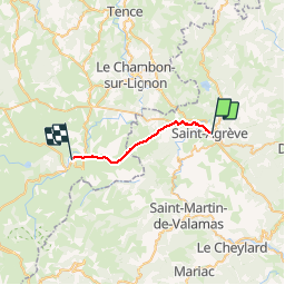
Trail Walking of 17.3 km to be discovered at Auvergne-Rhône-Alpes, Ardèche, Saint-Agrève. This trail is proposed by richard21220.
Description
Central Hôtel : Le Bourg 43430 FAY SUR LIGNON Tél 04 71 59 50 76
Gîte d'Etape La Traverse : Le Bourg 43430 FAY SUR LIGNON Tél 04 71 59 51 07
Positioning
Country:
France
Region :
Auvergne-Rhône-Alpes
Department/Province :
Ardèche
Municipality :
Saint-Agrève
Location:
Unknown
Start:(Dec)
Start:(UTM)
610137 ; 4984899 (31T) N.
Comments
Trails nearby
![Trail Walking Saint-Jeure-d'Andaure - En pays d'Andaure - Photo](https://media.geolcdn.com/t/375/260/ext.jpg?maxdim=2&url=https%3A%2F%2Fservices.sitytrail.com%2FGeolivesWS%2FDownloadMedia.ashx%3FTrailID%3D129815%26Media%3D13364_6.jpg)
![Walking Walking](https://static1.geolcdn.com/sitytour/trail-icons/101.png)
En pays d'Andaure
Walking
Medium
(1)
Saint-Jeure-d'Andaure,
Auvergne-Rhône-Alpes,
Ardèche,
France
![](/images/other/stat-length.png)
6.8 km | 10.1 km-effort
2h 30min
![](https://static1.geolcdn.com/siteimages/upload/files/16400158638029165_repeat_loop_refresh_sync_direction_icon.png)
Yes
![Trail Walking Saint-Agrève - La chaux par les Sagnoles - Photo](https://media.geolcdn.com/t/375/260/2ec8b69d-9d2d-4eb0-8ab2-4718ed369489.jpg&format=jpg&maxdim=2)
![Walking Walking](https://static1.geolcdn.com/sitytour/trail-icons/101.png)
La chaux par les Sagnoles
Walking
Medium
(1)
Saint-Agrève,
Auvergne-Rhône-Alpes,
Ardèche,
France
![](/images/other/stat-length.png)
6.4 km | 8.9 km-effort
2h 17min
![](https://static1.geolcdn.com/siteimages/upload/files/16400158638029165_repeat_loop_refresh_sync_direction_icon.png)
Yes
![Trail Walking Saint-Agrève - Le serre par le col de brun - Photo](https://media.geolcdn.com/t/375/260/0ab7f4ef-e569-4c05-ab5d-1eb0828a7e96.jpg&format=jpg&maxdim=2)
![Walking Walking](https://static1.geolcdn.com/sitytour/trail-icons/101.png)
Le serre par le col de brun
Walking
Easy
Saint-Agrève,
Auvergne-Rhône-Alpes,
Ardèche,
France
![](/images/other/stat-length.png)
4.1 km | 5.1 km-effort
1h 20min
![](https://static1.geolcdn.com/siteimages/upload/files/16400158638029165_repeat_loop_refresh_sync_direction_icon.png)
Yes
![Trail Mountain bike Saint-Agrève - Château de Flossac - Saint Agrève - Photo](https://media.geolcdn.com/t/375/260/ext.jpg?maxdim=2&url=https%3A%2F%2Fservices.sitytrail.com%2FGeolivesWS%2FDownloadMedia.ashx%3FTrailID%3D215181%26Media%3D15781_6.jpg)
![Mountain bike Mountain bike](https://static1.geolcdn.com/sitytour/trail-icons/202.png)
Château de Flossac - Saint Agrève
Mountain bike
Medium
Saint-Agrève,
Auvergne-Rhône-Alpes,
Ardèche,
France
![](/images/other/stat-length.png)
14.5 km | 19.1 km-effort
2h 0min
![](https://static1.geolcdn.com/siteimages/upload/files/16400158638029165_repeat_loop_refresh_sync_direction_icon.png)
Yes
![Trail Walking Saint-Agrève - Château de Flossac - Saint Agrève - Photo](https://media.geolcdn.com/t/375/260/ext.jpg?maxdim=2&url=https%3A%2F%2Fservices.sitytrail.com%2FGeolivesWS%2FDownloadMedia.ashx%3FTrailID%3D215180%26Media%3D15781_6.jpg)
![Walking Walking](https://static1.geolcdn.com/sitytour/trail-icons/101.png)
Château de Flossac - Saint Agrève
Walking
Medium
Saint-Agrève,
Auvergne-Rhône-Alpes,
Ardèche,
France
![](/images/other/stat-length.png)
14.5 km | 19.1 km-effort
4h 0min
![](https://static1.geolcdn.com/siteimages/upload/files/16400158638029165_repeat_loop_refresh_sync_direction_icon.png)
Yes
![Trail Walking Saint-Agrève - Saint-Agrève - Photo](https://media.geolcdn.com/t/375/260/f29c2b82-43c8-4052-a60d-cd95cfb4626d.jpg&format=jpg&maxdim=2)
![Walking Walking](https://static1.geolcdn.com/sitytour/trail-icons/101.png)
Saint-Agrève
Walking
Medium
Saint-Agrève,
Auvergne-Rhône-Alpes,
Ardèche,
France
![](/images/other/stat-length.png)
15.3 km | 19.2 km-effort
4h 4min
![](https://static1.geolcdn.com/siteimages/upload/files/16400158638029165_repeat_loop_refresh_sync_direction_icon.png)
Yes
![Trail Walking Saint-Julien-d'Intres - dolce via autour d'intres - Photo](https://media.geolcdn.com/t/375/260/6fbf7f44-82be-4874-938e-1b127a40d4fe.jpg&format=jpg&maxdim=2)
![Walking Walking](https://static1.geolcdn.com/sitytour/trail-icons/101.png)
dolce via autour d'intres
Walking
Medium
Saint-Julien-d'Intres,
Auvergne-Rhône-Alpes,
Ardèche,
France
![](/images/other/stat-length.png)
5.9 km | 9 km-effort
1h 47min
![](https://static1.geolcdn.com/siteimages/upload/files/16400158638029165_repeat_loop_refresh_sync_direction_icon.png)
Yes
![Trail Walking Devesset - Tour du lac Devesset - Photo](https://media.geolcdn.com/t/375/260/799511a5-cd66-4185-9dfe-fcafa1be1770.jpg&format=jpg&maxdim=2)
![Walking Walking](https://static1.geolcdn.com/sitytour/trail-icons/101.png)
Tour du lac Devesset
Walking
Very easy
Devesset,
Auvergne-Rhône-Alpes,
Ardèche,
France
![](/images/other/stat-length.png)
4.9 km | 5.8 km-effort
1h 18min
![](https://static1.geolcdn.com/siteimages/upload/files/16400158638029165_repeat_loop_refresh_sync_direction_icon.png)
Yes
![Trail Walking Devesset - le grail - Photo](https://media.geolcdn.com/t/375/260/2b05e325-e4fc-4530-95a7-2b1114c525d0.jpg&format=jpg&maxdim=2)
![Walking Walking](https://static1.geolcdn.com/sitytour/trail-icons/101.png)
le grail
Walking
Very easy
Devesset,
Auvergne-Rhône-Alpes,
Ardèche,
France
![](/images/other/stat-length.png)
12 km | 0 m-effort
4h 2min
![](https://static1.geolcdn.com/siteimages/upload/files/16400158638029165_repeat_loop_refresh_sync_direction_icon.png)
Yes