![](/images/other/stat-length.png)
![Trail Walking Roquevaire - Garlaban par le grand vallon - Photo](https://media.geolcdn.com/t/1900/400/ext.pjpeg?maxdim=2&url=https%3A%2F%2Fstatic1.geolcdn.com%2Fsiteimages%2Fupload%2Ffiles%2F1553511878bg_sport_marche.png)
Garlaban par le grand vallon
ARPF
User
![Length](/images/other/stat-length.png)
Length
12.5 km
![Max alt](https://static1.geolcdn.com/siteimages/upload/files/1508320355ic_sort_altitude_max_24dp.png)
Max alt
694 m
![Uphill gradient](https://static1.geolcdn.com/siteimages/upload/files/1508320355ic_sort_den_pos_24dp.png)
Uphill gradient
702 m
![Km-Effort](/images/other/stat-length.png)
Km-Effort
22 km
![Min alt](https://static1.geolcdn.com/siteimages/upload/files/1508320355ic_sort_altitude_min_24dp.png)
Min alt
202 m
![Downhill gradient](https://static1.geolcdn.com/siteimages/upload/files/1508320355ic_sort_den_neg_24dp.png)
Downhill gradient
703 m
![Boucle](https://static1.geolcdn.com/siteimages/upload/files/16400158638029165_repeat_loop_refresh_sync_direction_icon.png)
Boucle
Yes
Creation date :
2017-01-03 00:00:00.0
Updated on :
2017-01-03 00:00:00.0
![Walking](https://static1.geolcdn.com/sitytour/trail-icons/101.png)
6h23
Difficulty : Difficult
![Scan this QR Code to open this trail in the SityTrail application](https://capi.geolives.com/qq0zvz2zws4bq2lad0pu/sitytour/trails/679719/qr.png?size=200)
FREE GPS app for hiking
About
Trail Walking of 12.5 km to be discovered at Provence-Alpes-Côte d'Azur, Bouches-du-Rhône, Roquevaire. This trail is proposed by ARPF.
Description
P3 T3 Reco du 3/01/17 Philippe/Jacques/Michel
Plusieurs passages difficiles et vertigineux avec chaînes (4m à la verticale), prévoir corde.
Mais superbe vallon.
Positioning
Country:
France
Region :
Provence-Alpes-Côte d'Azur
Department/Province :
Bouches-du-Rhône
Municipality :
Roquevaire
Location:
Unknown
Start:(Dec)
Start:(UTM)
709346 ; 4802286 (31T) N.
Comments
Trails nearby
![Trail Walking Aubagne - SityTrail - Le garlaban - Aubagne - Photo](https://media.geolcdn.com/t/375/260/5276df7a-e0a5-4ee7-8341-ba0ac66cb09a.jpg&format=jpg&maxdim=2)
![Walking Walking](https://static1.geolcdn.com/sitytour/trail-icons/101.png)
SityTrail - Le garlaban - Aubagne
Walking
Difficult
(1)
Aubagne,
Provence-Alpes-Côte d'Azur,
Bouches-du-Rhône,
France
![](/images/other/stat-length.png)
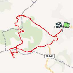
14.2 km | 24 km-effort
7h 0min
![](https://static1.geolcdn.com/siteimages/upload/files/16400158638029165_repeat_loop_refresh_sync_direction_icon.png)
Yes
![Trail Walking Aubagne - font de mai de Jean claude - Photo](https://media.geolcdn.com/t/375/260/f6c60e66-e9fc-4307-8f99-8e0be87e1440.jpg&format=jpg&maxdim=2)
![Walking Walking](https://static1.geolcdn.com/sitytour/trail-icons/101.png)
font de mai de Jean claude
Walking
Difficult
(1)
Aubagne,
Provence-Alpes-Côte d'Azur,
Bouches-du-Rhône,
France
![](/images/other/stat-length.png)
8.8 km | 12.8 km-effort
2h 54min
![](https://static1.geolcdn.com/siteimages/upload/files/16400158638029165_repeat_loop_refresh_sync_direction_icon.png)
Yes
![Trail Walking Allauch - Le tour des Grands Ubacs au départ de Pichauris - Photo](https://media.geolcdn.com/t/375/260/21675de2-6304-4cb6-a0f7-b5d15f62bb3e.jpg&format=jpg&maxdim=2)
![Walking Walking](https://static1.geolcdn.com/sitytour/trail-icons/101.png)
Le tour des Grands Ubacs au départ de Pichauris
Walking
Easy
(1)
Allauch,
Provence-Alpes-Côte d'Azur,
Bouches-du-Rhône,
France
![](/images/other/stat-length.png)
13.3 km | 20 km-effort
4h 25min
![](https://static1.geolcdn.com/siteimages/upload/files/16400158638029165_repeat_loop_refresh_sync_direction_icon.png)
Yes
![Trail Walking Allauch - Domaine de Pichauris - Allauch - Photo](https://media.geolcdn.com/t/375/260/ext.jpg?maxdim=2&url=https%3A%2F%2Fservices.sitytrail.com%2FGeolivesWS%2FDownloadMedia.ashx%3FTrailID%3D103813%26Media%3D6587_1.jpg)
![Walking Walking](https://static1.geolcdn.com/sitytour/trail-icons/101.png)
Domaine de Pichauris - Allauch
Walking
Medium
(1)
Allauch,
Provence-Alpes-Côte d'Azur,
Bouches-du-Rhône,
France
![](/images/other/stat-length.png)
10.5 km | 15 km-effort
2h 30min
![](https://static1.geolcdn.com/siteimages/upload/files/16400158638029165_repeat_loop_refresh_sync_direction_icon.png)
Yes
![Trail Walking Allauch - le pic du Taoumé par Pichauris - Photo](https://media.geolcdn.com/t/375/260/6e9ae51a-41c8-431b-88f6-0e231e4db660.jpg&format=jpg&maxdim=2)
![Walking Walking](https://static1.geolcdn.com/sitytour/trail-icons/101.png)
le pic du Taoumé par Pichauris
Walking
Easy
Allauch,
Provence-Alpes-Côte d'Azur,
Bouches-du-Rhône,
France
![](/images/other/stat-length.png)
13.3 km | 20 km-effort
4h 32min
![](https://static1.geolcdn.com/siteimages/upload/files/16400158638029165_repeat_loop_refresh_sync_direction_icon.png)
Yes
![Trail On foot Auriol - Les moulins - Photo](https://media.geolcdn.com/t/375/260/401f3ad9-0fae-41b8-b152-a635d6eb468f.jpeg&format=jpg&maxdim=2)
![On foot On foot](https://static1.geolcdn.com/sitytour/trail-icons/100.png)
Les moulins
On foot
Easy
Auriol,
Provence-Alpes-Côte d'Azur,
Bouches-du-Rhône,
France
![](/images/other/stat-length.png)
3.7 km | 4.2 km-effort
57min
![](https://static1.geolcdn.com/siteimages/upload/files/16400158638029165_repeat_loop_refresh_sync_direction_icon.png)
Yes
![Trail Walking Roquevaire - Garlaban au départ de Lascours - Photo](https://media.geolcdn.com/t/375/260/e8a027be-5d3d-4b87-97ab-2a7a8d8e3a15.jpg&format=jpg&maxdim=2)
![Walking Walking](https://static1.geolcdn.com/sitytour/trail-icons/101.png)
Garlaban au départ de Lascours
Walking
Difficult
Roquevaire,
Provence-Alpes-Côte d'Azur,
Bouches-du-Rhône,
France
![](/images/other/stat-length.png)
15.6 km | 26 km-effort
6h 1min
![](https://static1.geolcdn.com/siteimages/upload/files/16400158638029165_repeat_loop_refresh_sync_direction_icon.png)
Yes
![Trail Mountain bike Allauch - de Pichauris au mont du Marseillais - Photo](https://media.geolcdn.com/t/375/260/ext.jpg?maxdim=2&url=https%3A%2F%2Fservices.sitytrail.com%2FGeolivesWS%2FDownloadMedia.ashx%3FTrailID%3D855696%26Media%3Dfix__20171101163219.jpg)
![Mountain bike Mountain bike](https://static1.geolcdn.com/sitytour/trail-icons/202.png)
de Pichauris au mont du Marseillais
Mountain bike
Medium
Allauch,
Provence-Alpes-Côte d'Azur,
Bouches-du-Rhône,
France
![](/images/other/stat-length.png)
14 km | 19.2 km-effort
2h 34min
![](https://static1.geolcdn.com/siteimages/upload/files/16400158638029165_repeat_loop_refresh_sync_direction_icon.png)
Yes
![Trail Walking Roquevaire - le mont du marseillais par le grand Vallon - Photo](https://media.geolcdn.com/t/375/260/ext.jpg?maxdim=2&url=https%3A%2F%2Fservices.sitytrail.com%2FGeolivesWS%2FDownloadMedia.ashx%3FTrailID%3D506657%26Media%3Dfix__20151227145231.jpg)
![Walking Walking](https://static1.geolcdn.com/sitytour/trail-icons/101.png)
le mont du marseillais par le grand Vallon
Walking
Difficult
Roquevaire,
Provence-Alpes-Côte d'Azur,
Bouches-du-Rhône,
France
![](/images/other/stat-length.png)
9.9 km | 15.9 km-effort
4h 50min
![](https://static1.geolcdn.com/siteimages/upload/files/16400158638029165_repeat_loop_refresh_sync_direction_icon.png)
Yes