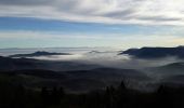

67 Hohwald Charbonnière

LUTZMarc
User

Length
23 km

Max alt
1103 m

Uphill gradient
779 m

Km-Effort
33 km

Min alt
562 m

Downhill gradient
784 m
Boucle
Yes
Creation date :
2016-12-22 00:00:00.0
Updated on :
2016-12-22 00:00:00.0
6h57
Difficulty : Medium

FREE GPS app for hiking
About
Trail Walking of 23 km to be discovered at Grand Est, Bas-Rhin, Le Hohwald. This trail is proposed by LUTZMarc.
Description
Très belle randonnée à faire de préférence en hiver ou au printemps pour profiter des points de vue. En été il y a de longue partie à l' ombre des feuillages, le parcours est un peu moins varié.
Parcours vallonné avec deux montées assez usantes.
Positioning
Country:
France
Region :
Grand Est
Department/Province :
Bas-Rhin
Municipality :
Le Hohwald
Location:
Unknown
Start:(Dec)
Start:(UTM)
376506 ; 5362604 (32U) N.
Comments
Trails nearby
2024-09-03_17h19m14_suuntoapp-HorsebackRiding-2024-09-03T08-25-34Z-track


Horseback riding
Medium
Ottrott,
Grand Est,
Bas-Rhin,
France

18.8 km | 26 km-effort
3h 23min
Yes
suuntoapp-Hiking-2024-04-27T09-12-29Z


Walking
Medium
Le Hohwald,
Grand Est,
Bas-Rhin,
France

20 km | 31 km-effort
6h 58min
Yes
2019-12-28 Marche Reichsfeld Ungersberg Gruckert


Walking
Very easy
Reichsfeld,
Grand Est,
Bas-Rhin,
France

12.2 km | 20 km-effort
3h 5min
Yes

Tour du Hohwald


Walking
Medium
(1)
Le Hohwald,
Grand Est,
Bas-Rhin,
France

8 km | 11.3 km-effort
2h 26min
Yes

2013-12-29 Marche Mt Ste Odile Maennelstein Birkenfels


Walking
Medium
(1)
Ottrott,
Grand Est,
Bas-Rhin,
France

10.8 km | 15.4 km-effort
3h 24min
Yes
Hohwald - Rothlach - Neuntelstein


Walking
Medium
(1)
Le Hohwald,
Grand Est,
Bas-Rhin,
France

15.8 km | 22 km-effort
4h 28min
Yes
Champ du feu début


On foot
Easy
Le Hohwald,
Grand Est,
Bas-Rhin,
France

6.8 km | 9.6 km-effort
2h 10min
No
le hohwald, boucle "petite ceinture"


Walking
Easy
(1)
Le Hohwald,
Grand Est,
Bas-Rhin,
France

3.4 km | 4.8 km-effort
55min
Yes
Hohwald (ter)


Walking
Difficult
Le Hohwald,
Grand Est,
Bas-Rhin,
France

11.2 km | 15.6 km-effort
3h 31min
Yes


 SityTrail


