Trail Other activity Pavilly - Haute - Normandie - Ligne 351 - Barentin - Caudebec-en-Caux - Photo

Haute - Normandie - Ligne 351 - Barentin - Caudebec-en-Caux

 mich54
mich54

User

© OpenStreetMap contributors
Length
Length
26 km
Max alt
Max alt
76 m
Uphill gradient
Uphill gradient
226 m
Km-Effort
Km-Effort  
29 km
Min alt
Min alt
2 m
Downhill gradient
Downhill gradient
287 m
Boucle
Boucle
No
Creation date :
2016-12-20 00:00:00.0
Updated on :
2016-12-20 00:00:00.0

(0 Reviews)

Other activity
Other activity
5m
Difficulty : Unknown

Scan this QR Code to open this trail in the SityTrail application

FREE GPS app for hiking

Logo SityTrail SityTrail

IGN / Geographical institutes

Download SityTrail from the App Store Download SityTrail from Google Play

Logo SityTrail SityTrail World

The world is yours!

Download SityTrail from the App Store Download SityTrail from Google Play Download SityTrail on Huawei AppGallery

About

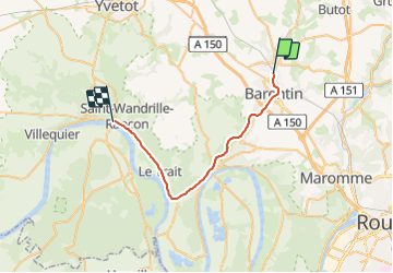
Trail Other activity of 26 km to be discovered at Normandy, Seine-Maritime, Pavilly. This trail is proposed by mich54.

Description

La ligne de Barentin à Caudebec-en-Caux est une voie ferrée française à écartement standard, sise dans le département de Seine-Inférieure (aujourd'hui Seine-Maritime), établie par la Compagnie des chemins de fer de l'Ouest. Inauguré en deux étapes, en 1881 et 1882, ce chemin de fer fut fermé aux voyageurs en 1949, puis aux marchandises en 1990. Cette ligne peut être considérée comme une antenne de la grande radiale Paris-Le Havre desservant à partir de la gare de Barentin les communes à vocation industrielle situées sur la rive droite de la Seine.

Elle constitue la ligne 351 0001 du réseau ferré national.(Source Wikipédia)

Elevation profile

Positioning

Country:
France
Region :
Normandy
Department/Province :
Seine-Maritime
Municipality :
Pavilly
Location:
Unknown
Start:(UTM)
351900 ; 5491984 (31U) N.

Trails nearby

Trail Walking Pavilly - 076-90-Pavilly / St Autreberthe  13.5km - Photo
Walking
rvs147

Walking

Medium
(1)
Pavilly, Normandy, Seine-Maritime, France
12 km | 15 km-effort
3h 23min
Yes
Trail Walking Barentin - 20221006-Barentin  - Photo
Walking
doudet

Walking

Medium
Barentin, Normandy, Seine-Maritime, France
13.7 km | 16.1 km-effort
3h 40min
Yes
Trail Walking Pavilly - 20220203-Pavilly - Photo
Walking
doudet

Walking

Medium
Pavilly, Normandy, Seine-Maritime, France
12.1 km | 15 km-effort
3h 36min
Yes
Trail Walking Pavilly - Pavilly St. Austreberthe (51) - Photo
Walking
randovivi

Walking

Easy
(2)
Pavilly, Normandy, Seine-Maritime, France
10.3 km | 13 km-effort
2h 49min
Yes
Trail Walking Barentin - barentin balades contées oeuvres sreet art  - Photo
Walking
nicole.reine@wanadoo.fr

Walking

Easy
Barentin, Normandy, Seine-Maritime, France
1.9 km | 2.1 km-effort
2h 17min
No
Trail Walking Goupillières - Goupillieres 6 - Photo
Walking
francois duparc

Walking

Easy
Goupillières, Normandy, Seine-Maritime, France
6.8 km | 7.6 km-effort
1h 40min
Yes
Trail On foot Hugleville-en-Caux - Le Bois de Grofys - Photo
On foot
GUIDE+

On foot

Easy
Hugleville-en-Caux, Normandy, Seine-Maritime, France
11.6 km | 13.3 km-effort
3h 1min
Yes
Trail On foot Pavilly - 2020-01-22_15h00m10_20200125-pavilly - Photo
On foot
rvs147

On foot

Very easy
Pavilly, Normandy, Seine-Maritime, France
13 km | 16 km-effort
Unknown
Yes
Trail Walking Sainte-Austreberthe - Ste Austreberthe Pavilly A-R - Photo
Walking
MichelARRP

Walking

Difficult
Sainte-Austreberthe, Normandy, Seine-Maritime, France
12.5 km | 15.6 km-effort
3h 7min
Yes


Close
My subscriptions