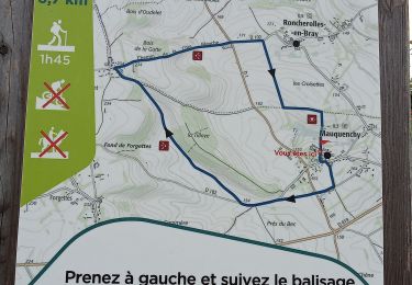
![](/images/other/stat-length.png)
![Trail Other activity Serqueux - Haute - Normandie - Ligne 330 - Saint-Denis - Dieppe (Section de Serqueux à Dieppe) - Photo](https://media.geolcdn.com/t/1900/400/ext.pjpeg?maxdim=2&url=https%3A%2F%2Fstatic1.geolcdn.com%2Fsiteimages%2Fupload%2Ffiles%2F1545311037marcheuse_200dpi.jpg)
Haute - Normandie - Ligne 330 - Saint-Denis - Dieppe (Section de Serqueux à Dieppe)
mich54
User
![Length](/images/other/stat-length.png)
![Max alt](https://static1.geolcdn.com/siteimages/upload/files/1508320355ic_sort_altitude_max_24dp.png)
![Uphill gradient](https://static1.geolcdn.com/siteimages/upload/files/1508320355ic_sort_den_pos_24dp.png)
![Km-Effort](/images/other/stat-length.png)
![Min alt](https://static1.geolcdn.com/siteimages/upload/files/1508320355ic_sort_altitude_min_24dp.png)
![Downhill gradient](https://static1.geolcdn.com/siteimages/upload/files/1508320355ic_sort_den_neg_24dp.png)
![Boucle](https://static1.geolcdn.com/siteimages/upload/files/16400158638029165_repeat_loop_refresh_sync_direction_icon.png)
![Other activity](https://static1.geolcdn.com/sitytour/trail-icons/900.png)
5m
Difficulty : Unknown
![Scan this QR Code to open this trail in the SityTrail application](https://capi.geolives.com/qq0zvz2zws4bq2lad0pu/sitytour/trails/674502/qr.png?size=200)
FREE GPS app for hiking
About
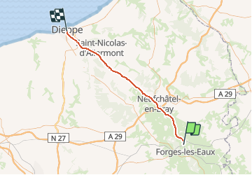
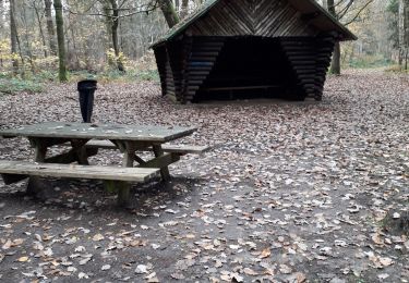
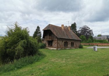
Trail Other activity of 49 km to be discovered at Normandy, Seine-Maritime, Serqueux. This trail is proposed by mich54.
Description
La ligne de Saint-Denis à Dieppe, est une ligne ferroviaire française reliant la gare de Saint-Denis, en proche banlieue nord de Paris, à la gare de Dieppe, en Seine-Maritime. D’une longueur de 161 km seulement, elle est la plus courte ligne à avoir été construite entre Paris et la mer. Elle constitue la ligne no 330 000 du réseau ferré national1.Le 15 décembre 2013, le trafic a repris entre Gisors et Serqueux. La ligne est désormais ouverte aux voyageurs de Saint-Denis à Serqueux en utilisant les trains de banlieue du réseau Transilien et les TER Haute-Normandie de Gisors à Serqueux.(Source Wikipédia)
Détail important : elle est transformée en voie verte sur pratiquement tout le parcours.
Positioning
Comments
Trails nearby
![Trail Walking Forges-les-Eaux - Forges les Eaux.Vers la fontaine de la Chevrette - Photo](https://media.geolcdn.com/t/375/260/80600cea-4aa9-40e3-b70d-5e1e128fe7fe.jpg&format=jpg&maxdim=2)
![Walking Walking](https://static1.geolcdn.com/sitytour/trail-icons/101.png)
Walking
![](/images/other/stat-length.png)
![](https://static1.geolcdn.com/siteimages/upload/files/16400158638029165_repeat_loop_refresh_sync_direction_icon.png)
![Trail Walking Forges-les-Eaux - Forges - Serqueux par voie verte puis campagne - Photo](https://media.geolcdn.com/t/375/260/973065ad-678f-4a67-a35e-a1a180b6ec70.jpg&format=jpg&maxdim=2)
![Walking Walking](https://static1.geolcdn.com/sitytour/trail-icons/101.png)
Walking
![](/images/other/stat-length.png)
![](https://static1.geolcdn.com/siteimages/upload/files/16400158638029165_repeat_loop_refresh_sync_direction_icon.png)
![Trail Walking Mauquenchy - Mauquenchy . - Photo](https://media.geolcdn.com/t/375/260/149259e6-8129-475e-840b-24f0ef03a0f3.jpg&format=jpg&maxdim=2)
![Walking Walking](https://static1.geolcdn.com/sitytour/trail-icons/101.png)
Walking
![](/images/other/stat-length.png)
![](https://static1.geolcdn.com/siteimages/upload/files/16400158638029165_repeat_loop_refresh_sync_direction_icon.png)
![Trail Walking Forges-les-Eaux - Forges les eaux . Lacs et forets - Photo](https://media.geolcdn.com/t/375/260/9aad1954-c46d-49ac-8360-d8627d21ad99.jpg&format=jpg&maxdim=2)
![Walking Walking](https://static1.geolcdn.com/sitytour/trail-icons/101.png)
Walking
![](/images/other/stat-length.png)
![](https://static1.geolcdn.com/siteimages/upload/files/16400158638029165_repeat_loop_refresh_sync_direction_icon.png)
![Trail Walking Forges-les-Eaux - forges les eaux - Photo](https://media.geolcdn.com/t/375/260/7e5d9713-acf6-4654-b283-760782fe98f3.jpg&format=jpg&maxdim=2)
![Walking Walking](https://static1.geolcdn.com/sitytour/trail-icons/101.png)
Walking
![](/images/other/stat-length.png)
![](https://static1.geolcdn.com/siteimages/upload/files/16400158638029165_repeat_loop_refresh_sync_direction_icon.png)
![Trail On foot Roncherolles-en-Bray - FR-9 - Photo](https://media.geolcdn.com/t/375/260/ext.jpg?maxdim=2&url=https%3A%2F%2Fstatic1.geolcdn.com%2Fsiteimages%2Fupload%2Ffiles%2F1545311037marcheuse_200dpi.jpg)
![On foot On foot](https://static1.geolcdn.com/sitytour/trail-icons/100.png)
On foot
![](/images/other/stat-length.png)
![](https://static1.geolcdn.com/siteimages/upload/files/16400158638029165_repeat_loop_refresh_sync_direction_icon.png)
![Trail On foot Mesnil-Mauger - FR-10 - Photo](https://media.geolcdn.com/t/375/260/ext.jpg?maxdim=2&url=https%3A%2F%2Fstatic1.geolcdn.com%2Fsiteimages%2Fupload%2Ffiles%2F1545311037marcheuse_200dpi.jpg)
![On foot On foot](https://static1.geolcdn.com/sitytour/trail-icons/100.png)
On foot
![](/images/other/stat-length.png)
![](https://static1.geolcdn.com/siteimages/upload/files/16400158638029165_repeat_loop_refresh_sync_direction_icon.png)
![Trail Bicycle tourism Forges-les-Eaux - vtt - Photo](https://media.geolcdn.com/t/375/260/ext.jpg?maxdim=2&url=https%3A%2F%2Fstatic1.geolcdn.com%2Fsiteimages%2Fupload%2Ffiles%2F1524743154velo.jpg)
![Bicycle tourism Bicycle tourism](https://static1.geolcdn.com/sitytour/trail-icons/204.png)
Bicycle tourism
![](/images/other/stat-length.png)
![](https://static1.geolcdn.com/siteimages/upload/files/16400158638029165_repeat_loop_refresh_sync_direction_icon.png)
![Trail Walking Serqueux - Forges A32 - Photo](https://media.geolcdn.com/t/375/260/ext.jpg?maxdim=2&url=https%3A%2F%2Fstatic1.geolcdn.com%2Fsiteimages%2Fupload%2Ffiles%2F1553511878bg_sport_marche.png)
![Walking Walking](https://static1.geolcdn.com/sitytour/trail-icons/101.png)
Walking
![](/images/other/stat-length.png)
![](https://static1.geolcdn.com/siteimages/upload/files/16400158638029165_repeat_loop_refresh_sync_direction_icon.png)