![](/images/other/stat-length.png)
![Trail Walking Gibloux - Vuisternens-en-Ogoz - Farvagny-le-Grand - Photo](https://media.geolcdn.com/t/1900/400/ext.pjpeg?maxdim=2&url=https%3A%2F%2Fstatic1.geolcdn.com%2Fsiteimages%2Fupload%2Ffiles%2F1553511878bg_sport_marche.png)
Vuisternens-en-Ogoz - Farvagny-le-Grand
hgauchat
User
![Length](/images/other/stat-length.png)
Length
8.5 km
![Max alt](https://static1.geolcdn.com/siteimages/upload/files/1508320355ic_sort_altitude_max_24dp.png)
Max alt
864 m
![Uphill gradient](https://static1.geolcdn.com/siteimages/upload/files/1508320355ic_sort_den_pos_24dp.png)
Uphill gradient
176 m
![Km-Effort](/images/other/stat-length.png)
Km-Effort
10.8 km
![Min alt](https://static1.geolcdn.com/siteimages/upload/files/1508320355ic_sort_altitude_min_24dp.png)
Min alt
728 m
![Downhill gradient](https://static1.geolcdn.com/siteimages/upload/files/1508320355ic_sort_den_neg_24dp.png)
Downhill gradient
175 m
![Boucle](https://static1.geolcdn.com/siteimages/upload/files/16400158638029165_repeat_loop_refresh_sync_direction_icon.png)
Boucle
Yes
Creation date :
2017-06-02 00:00:00.0
Updated on :
2017-06-02 00:00:00.0
![Walking](https://static1.geolcdn.com/sitytour/trail-icons/101.png)
2h19
Difficulty : Easy
![Scan this QR Code to open this trail in the SityTrail application](https://capi.geolives.com/qq0zvz2zws4bq2lad0pu/sitytour/trails/673103/qr.png?size=200)
FREE GPS app for hiking
About
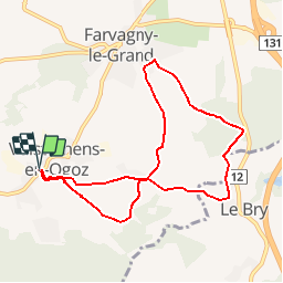
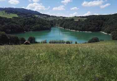
Trail Walking of 8.5 km to be discovered at Fribourg, Sarine District, Gibloux. This trail is proposed by hgauchat.
Description
Randonnée proposée par Yvan Gumy.
Romont/Bicubic- Villaz-St-Pierre -Orsonnens - Villarlod - Vuisternens-en-Ogoz ;
13Km /20min / Fr: 3.-.
Parking: A gauche, près de l'école.
Positioning
Country:
Switzerland
Region :
Fribourg
Department/Province :
Sarine District
Municipality :
Gibloux
Location:
Vuisternens-en-Ogoz
Start:(Dec)
Start:(UTM)
351129 ; 5174479 (32T) N.
Comments
Trails nearby
![Trail On foot Sorens - Circuit Le Gibloux crête tour - Photo](https://media.geolcdn.com/t/375/260/45e5a679-ea50-4f19-83c0-d4c049841f82.jpeg&format=jpg&maxdim=2)
![On foot On foot](https://static1.geolcdn.com/sitytour/trail-icons/100.png)
Circuit Le Gibloux crête tour
On foot
Easy
Sorens,
Fribourg,
Gruyère District,
Switzerland
![](/images/other/stat-length.png)
4.2 km | 6.9 km-effort
1h 33min
![](https://static1.geolcdn.com/siteimages/upload/files/16400158638029165_repeat_loop_refresh_sync_direction_icon.png)
Yes
![Trail Walking Gibloux - Farvagny - Photo](https://media.geolcdn.com/t/375/260/ext.jpg?maxdim=2&url=https%3A%2F%2Fstatic1.geolcdn.com%2Fsiteimages%2Fupload%2Ffiles%2F1553511878bg_sport_marche.png)
![Walking Walking](https://static1.geolcdn.com/sitytour/trail-icons/101.png)
Farvagny
Walking
Gibloux,
Fribourg,
Sarine District,
Switzerland
![](/images/other/stat-length.png)
8.5 km | 11.2 km-effort
2h 14min
![](https://static1.geolcdn.com/siteimages/upload/files/16400158638029165_repeat_loop_refresh_sync_direction_icon.png)
Yes
![Trail Walking Villorsonnens - Villarsiviriaux Esseiva - Photo](https://media.geolcdn.com/t/375/260/ext.jpg?maxdim=2&url=https%3A%2F%2Fstatic1.geolcdn.com%2Fsiteimages%2Fupload%2Ffiles%2F1553511878bg_sport_marche.png)
![Walking Walking](https://static1.geolcdn.com/sitytour/trail-icons/101.png)
Villarsiviriaux Esseiva
Walking
Medium
Villorsonnens,
Fribourg,
District de la Glâne,
Switzerland
![](/images/other/stat-length.png)
9.4 km | 11.8 km-effort
2h 32min
![](https://static1.geolcdn.com/siteimages/upload/files/16400158638029165_repeat_loop_refresh_sync_direction_icon.png)
Yes
![Trail Walking Pont-la-Ville - Pont-la-Ville en Gruyère, circuit 02.06.18 - Photo](https://media.geolcdn.com/t/375/260/ext.jpg?maxdim=2&url=https%3A%2F%2Fservices.sitytrail.com%2FGeolivesWS%2FDownloadMedia.ashx%3FTrailID%3D978829%26Media%3D46e34ab3-0c85-4ddb-abcb-61fa07df5a07.jpg)
![Walking Walking](https://static1.geolcdn.com/sitytour/trail-icons/101.png)
Pont-la-Ville en Gruyère, circuit 02.06.18
Walking
Easy
Pont-la-Ville,
Fribourg,
Gruyère District,
Switzerland
![](/images/other/stat-length.png)
13.8 km | 21 km-effort
4h 31min
![](https://static1.geolcdn.com/siteimages/upload/files/16400158638029165_repeat_loop_refresh_sync_direction_icon.png)
Yes
![Trail Walking Sorens - Tour du Gibloux 09.11.15 - Photo](https://media.geolcdn.com/t/375/260/ext.jpg?maxdim=2&url=https%3A%2F%2Fservices.sitytrail.com%2FGeolivesWS%2FDownloadMedia.ashx%3FTrailID%3D491818%26Media%3D1df59454-4e25-4d5f-aae9-f60d8fcf1172.jpg)
![Walking Walking](https://static1.geolcdn.com/sitytour/trail-icons/101.png)
Tour du Gibloux 09.11.15
Walking
Easy
Sorens,
Fribourg,
Gruyère District,
Switzerland
![](/images/other/stat-length.png)
9.9 km | 15.9 km-effort
4h 2min
![](https://static1.geolcdn.com/siteimages/upload/files/16400158638029165_repeat_loop_refresh_sync_direction_icon.png)
Yes
![Trail Walking Villorsonnens - Villarsiviriaux - Massonnens - Villargiroud - Villarsel-le-Gibloux - Villarlod - Photo](https://media.geolcdn.com/t/375/260/ext.jpg?maxdim=2&url=https%3A%2F%2Fstatic1.geolcdn.com%2Fsiteimages%2Fupload%2Ffiles%2F1553511878bg_sport_marche.png)
![Walking Walking](https://static1.geolcdn.com/sitytour/trail-icons/101.png)
Villarsiviriaux - Massonnens - Villargiroud - Villarsel-le-Gibloux - Villarlod
Walking
Easy
Villorsonnens,
Fribourg,
District de la Glâne,
Switzerland
![](/images/other/stat-length.png)
10.6 km | 13.1 km-effort
2h 50min
![](https://static1.geolcdn.com/siteimages/upload/files/16400158638029165_repeat_loop_refresh_sync_direction_icon.png)
Yes
![Trail Other activity Gibloux - Villarlod - Romont - Photo](https://media.geolcdn.com/t/375/260/ext.jpg?maxdim=2&url=https%3A%2F%2Fstatic1.geolcdn.com%2Fsiteimages%2Fupload%2Ffiles%2F1545311037marcheuse_200dpi.jpg)
![Other activity Other activity](https://static1.geolcdn.com/sitytour/trail-icons/900.png)
Villarlod - Romont
Other activity
Very easy
Gibloux,
Fribourg,
Sarine District,
Switzerland
![](/images/other/stat-length.png)
10.8 km | 13.2 km-effort
Unknown
![](https://static1.geolcdn.com/siteimages/upload/files/16400158638029165_repeat_loop_refresh_sync_direction_icon.png)
No
![Trail Nordic walking Sorens - neige - Photo](https://media.geolcdn.com/t/375/260/ext.jpg?maxdim=2&url=https%3A%2F%2Fstatic1.geolcdn.com%2Fsiteimages%2Fupload%2Ffiles%2F1545311037marcheuse_200dpi.jpg)
![Nordic walking Nordic walking](https://static1.geolcdn.com/sitytour/trail-icons/102.png)
neige
Nordic walking
Very easy
Sorens,
Fribourg,
Gruyère District,
Switzerland
![](/images/other/stat-length.png)
3.9 km | 5.3 km-effort
1h 45min
![](https://static1.geolcdn.com/siteimages/upload/files/16400158638029165_repeat_loop_refresh_sync_direction_icon.png)
No
![Trail Walking Villorsonnens - Villarsiviriaux 04.08.2018 - Photo](https://media.geolcdn.com/t/375/260/ext.jpg?maxdim=2&url=https%3A%2F%2Fstatic1.geolcdn.com%2Fsiteimages%2Fupload%2Ffiles%2F1553511878bg_sport_marche.png)
![Walking Walking](https://static1.geolcdn.com/sitytour/trail-icons/101.png)
Villarsiviriaux 04.08.2018
Walking
Easy
Villorsonnens,
Fribourg,
District de la Glâne,
Switzerland
![](/images/other/stat-length.png)
9.3 km | 11.9 km-effort
2h 32min
![](https://static1.geolcdn.com/siteimages/upload/files/16400158638029165_repeat_loop_refresh_sync_direction_icon.png)
Yes