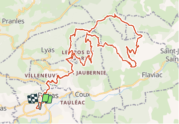
Trail Mountain bike Privas - Les Plaines Flaviac - Photo
 raphnou
raphnou

User

© OpenStreetMap contributors
Length
Length
32 km
Max alt
Max alt
808 m
Uphill gradient
Uphill gradient
1218 m
Km-Effort
Km-Effort  
49 km
Min alt
Min alt
225 m
Downhill gradient
Downhill gradient
1218 m
Boucle
Boucle
Yes
Creation date :
2016-12-11 00:00:00.0
Updated on :
2016-12-11 00:00:00.0

(0 Reviews)

Mountain bike
Mountain bike
3h03
Difficulty : Difficult

Scan this QR Code to open this trail in the SityTrail application

FREE GPS app for hiking

Logo SityTrail SityTrail

IGN / Geographical institutes

Download SityTrail from the App Store Download SityTrail from Google Play

Logo SityTrail SityTrail World

The world is yours!

Download SityTrail from the App Store Download SityTrail from Google Play Download SityTrail on Huawei AppGallery

About

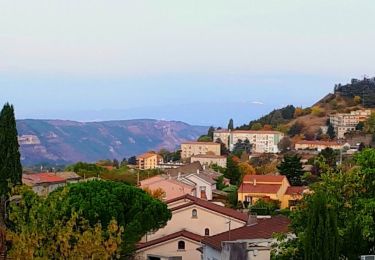
Trail Mountain bike of 32 km to be discovered at Auvergne-Rhône-Alpes, Ardèche, Privas. This trail is proposed by raphnou.

Description

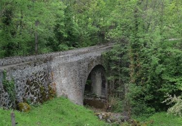
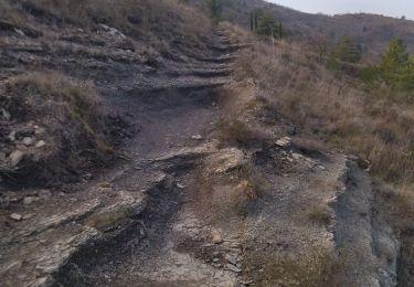
Départ parking du Lycée de Privas. Parcours typique d'Ardèche avec de la caillasses. Descentes techniques, montées raides, du vtt quoi...

Elevation profile

Positioning

Country:
France
Region :
Auvergne-Rhône-Alpes
Department/Province :
Ardèche
Municipality :
Privas
Location:
Unknown
Start:(UTM)
626197 ; 4953988 (31T) N.

Trails nearby

Trail Walking Lyas - 07 privas Livier zel - Photo
Walking
GUIDE
randodyssée

Walking

Medium
Lyas, Auvergne-Rhône-Alpes, Ardèche, France
18.1 km | 28 km-effort
6h 46min
Yes
Trail Walking Alissas - 07 Alissas rochessauve zel 23.11.22 - Photo
Walking
GUIDE
randodyssée

Walking

Easy
Alissas, Auvergne-Rhône-Alpes, Ardèche, France
15.3 km | 22 km-effort
6h 5min
Yes
Trail Walking Coux - Coux Serre Gruas 19km - Photo
Walking
GUIDE
thonyc

Walking

Medium
Coux, Auvergne-Rhône-Alpes, Ardèche, France
19.4 km | 29 km-effort
5h 25min
Yes
Trail Walking Saint-Priest - 07 st priest roc de gourdon - Photo
Walking
GUIDE
randodyssée

Walking

Difficult
Saint-Priest, Auvergne-Rhône-Alpes, Ardèche, France
18.3 km | 29 km-effort
8h 31min
Yes
Trail Walking Coux - Jaubernie - Photo
Walking
OscarMa

Walking

Easy
(2)
Coux, Auvergne-Rhône-Alpes, Ardèche, France
14.8 km | 22 km-effort
4h 41min
Yes
Trail Walking Coux - w-frankrijk-wandelroute-coux-ardeche - Photo
Walking
gpstracks

Walking

Very easy
(1)
Coux, Auvergne-Rhône-Alpes, Ardèche, France
5.8 km | 9.3 km-effort
Unknown
Yes
Trail Walking Coux - Coux 10km - Photo
Walking
GUIDE
thonyc

Walking

Medium
Coux, Auvergne-Rhône-Alpes, Ardèche, France
10.4 km | 16.1 km-effort
3h 0min
Yes
Trail Walking Coux - Coux - Photo
Walking
ajd26

Walking

Easy
Coux, Auvergne-Rhône-Alpes, Ardèche, France
15.9 km | 26 km-effort
4h 40min
Yes
Trail Walking Lyas - 07 privas veyras 01 04 2021 - Photo
Walking
GUIDE
randodyssée

Walking

Medium
Lyas, Auvergne-Rhône-Alpes, Ardèche, France
19.3 km | 29 km-effort
6h 49min
Yes


Close
My subscriptions