![](/images/other/stat-length.png)
![Trail Mountain bike Bondoufle - 2016-11-17 autour de Lardy avec tour de pocancy et cabane ILEX - Photo](https://media.geolcdn.com/t/1900/400/ext.pjpeg?maxdim=2&url=https%3A%2F%2Fservices.sitytrail.com%2FGeolivesWS%2FDownloadMedia.ashx%3FTrailID%3D670852%26Media%3Dfix__20161117165815.jpg)
2016-11-17 autour de Lardy avec tour de pocancy et cabane ILEX
Lucquiaud
User
![Length](/images/other/stat-length.png)
Length
48 km
![Max alt](https://static1.geolcdn.com/siteimages/upload/files/1508320355ic_sort_altitude_max_24dp.png)
Max alt
163 m
![Uphill gradient](https://static1.geolcdn.com/siteimages/upload/files/1508320355ic_sort_den_pos_24dp.png)
Uphill gradient
389 m
![Km-Effort](/images/other/stat-length.png)
Km-Effort
53 km
![Min alt](https://static1.geolcdn.com/siteimages/upload/files/1508320355ic_sort_altitude_min_24dp.png)
Min alt
57 m
![Downhill gradient](https://static1.geolcdn.com/siteimages/upload/files/1508320355ic_sort_den_neg_24dp.png)
Downhill gradient
392 m
![Boucle](https://static1.geolcdn.com/siteimages/upload/files/16400158638029165_repeat_loop_refresh_sync_direction_icon.png)
Boucle
Yes
Creation date :
2018-09-15 15:04:42.63
Updated on :
2018-09-15 15:04:42.796
![Mountain bike](https://static1.geolcdn.com/sitytour/trail-icons/202.png)
2h59
Difficulty : Medium
![Scan this QR Code to open this trail in the SityTrail application](https://capi.geolives.com/qq0zvz2zws4bq2lad0pu/sitytour/trails/670852/qr.png?size=200)
FREE GPS app for hiking
About
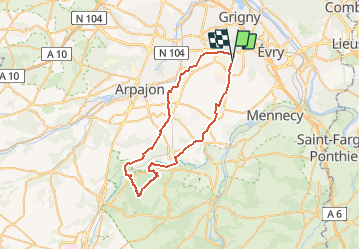
Trail Mountain bike of 48 km to be discovered at Ile-de-France, Essonne, Bondoufle. This trail is proposed by Lucquiaud.
Description
rando devant le château de Chamarande (détour possible), château de Gillevoisin, Tour de Pocancy et cabane ILEX, moulin de Goujon pour finir sur la Juine
Positioning
Country:
France
Region :
Ile-de-France
Department/Province :
Essonne
Municipality :
Bondoufle
Location:
Unknown
Start:(Dec)
Start:(UTM)
454058 ; 5384623 (31U) N.
Comments
Trails nearby
![Trail Walking Écharcon - Autour de Vert le Petit - Photo](https://media.geolcdn.com/t/375/260/ext.jpg?maxdim=2&url=https%3A%2F%2Fservices.sitytrail.com%2FGeolivesWS%2FDownloadMedia.ashx%3FTrailID%3D102739%26Media%3D3871_4.jpg)
![Walking Walking](https://static1.geolcdn.com/sitytour/trail-icons/101.png)
Autour de Vert le Petit
Walking
Medium
(1)
Écharcon,
Ile-de-France,
Essonne,
France
![](/images/other/stat-length.png)
16 km | 17.9 km-effort
4h 0min
![](https://static1.geolcdn.com/siteimages/upload/files/16400158638029165_repeat_loop_refresh_sync_direction_icon.png)
Yes
![Trail Mountain bike Bondoufle - rando](https://media.geolcdn.com/t/375/260/ext.jpg?maxdim=2&url=https%3A%2F%2Fstatic1.geolcdn.com%2Fsiteimages%2Fupload%2Ffiles%2F1524743154velo.jpg)
![Mountain bike Mountain bike](https://static1.geolcdn.com/sitytour/trail-icons/202.png)
rando "sec" dimanche 07/02/2021
Mountain bike
Easy
(1)
Bondoufle,
Ile-de-France,
Essonne,
France
![](/images/other/stat-length.png)
56 km | 63 km-effort
8min
![](https://static1.geolcdn.com/siteimages/upload/files/16400158638029165_repeat_loop_refresh_sync_direction_icon.png)
Yes
![Trail Mountain bike Bondoufle - Senart - Photo](https://media.geolcdn.com/t/375/260/ext.jpg?maxdim=2&url=https%3A%2F%2Fstatic1.geolcdn.com%2Fsiteimages%2Fupload%2Ffiles%2F1524743154velo.jpg)
![Mountain bike Mountain bike](https://static1.geolcdn.com/sitytour/trail-icons/202.png)
Senart
Mountain bike
Very difficult
(1)
Bondoufle,
Ile-de-France,
Essonne,
France
![](/images/other/stat-length.png)
46 km | 52 km-effort
3h 30min
![](https://static1.geolcdn.com/siteimages/upload/files/16400158638029165_repeat_loop_refresh_sync_direction_icon.png)
Yes
![Trail Mountain bike Bondoufle - Sortie club du 29/09/2019 - Photo](https://media.geolcdn.com/t/375/260/ext.jpg?maxdim=2&url=https%3A%2F%2Fstatic1.geolcdn.com%2Fsiteimages%2Fupload%2Ffiles%2F1524743154velo.jpg)
![Mountain bike Mountain bike](https://static1.geolcdn.com/sitytour/trail-icons/202.png)
Sortie club du 29/09/2019
Mountain bike
Difficult
(1)
Bondoufle,
Ile-de-France,
Essonne,
France
![](/images/other/stat-length.png)
32 km | 36 km-effort
2h 25min
![](https://static1.geolcdn.com/siteimages/upload/files/16400158638029165_repeat_loop_refresh_sync_direction_icon.png)
Yes
![Trail Walking Fleury-Mérogis - Fleury-Mérogis - Forêt Régionale de Saint-Eutrope - Photo](https://media.geolcdn.com/t/375/260/6448ff66-5599-4ef7-ab6f-bd578a291243.jpg&format=jpg&maxdim=2)
![Walking Walking](https://static1.geolcdn.com/sitytour/trail-icons/101.png)
Fleury-Mérogis - Forêt Régionale de Saint-Eutrope
Walking
Easy
Fleury-Mérogis,
Ile-de-France,
Essonne,
France
![](/images/other/stat-length.png)
6.3 km | 7 km-effort
1h 35min
![](https://static1.geolcdn.com/siteimages/upload/files/16400158638029165_repeat_loop_refresh_sync_direction_icon.png)
Yes
![Trail On foot Soisy-sur-Seine - Boucle Soisy / Seine / Sénart - Photo](https://media.geolcdn.com/t/375/260/4a1feccf-2abe-4449-b3b1-c318219c819e.jpg&format=jpg&maxdim=2)
![On foot On foot](https://static1.geolcdn.com/sitytour/trail-icons/100.png)
Boucle Soisy / Seine / Sénart
On foot
Very easy
Soisy-sur-Seine,
Ile-de-France,
Essonne,
France
![](/images/other/stat-length.png)
18.6 km | 21 km-effort
4h 49min
![](https://static1.geolcdn.com/siteimages/upload/files/16400158638029165_repeat_loop_refresh_sync_direction_icon.png)
Yes
![Trail sport Mennecy - De Mennecy à Corbeil-Essonnes par le Parc de Robinson - Photo](https://media.geolcdn.com/t/375/260/ext.jpg?maxdim=2&url=https%3A%2F%2Fsecurestorage.geolives.com%2Fsitytour%2Ftrail-bg%2Fdefault.jpg)
De Mennecy à Corbeil-Essonnes par le Parc de Robinson
sport
Very easy
(1)
Mennecy,
Ile-de-France,
Essonne,
France
![](/images/other/stat-length.png)
13.1 km | 14.6 km-effort
Unknown
![](https://static1.geolcdn.com/siteimages/upload/files/16400158638029165_repeat_loop_refresh_sync_direction_icon.png)
No
![Trail Mountain bike Bondoufle - Autodrome - Photo](https://media.geolcdn.com/t/375/260/ext.jpg?maxdim=2&url=https%3A%2F%2Fstatic1.geolcdn.com%2Fsiteimages%2Fupload%2Ffiles%2F1524743154velo.jpg)
![Mountain bike Mountain bike](https://static1.geolcdn.com/sitytour/trail-icons/202.png)
Autodrome
Mountain bike
Very difficult
(1)
Bondoufle,
Ile-de-France,
Essonne,
France
![](/images/other/stat-length.png)
48 km | 54 km-effort
3h 44min
![](https://static1.geolcdn.com/siteimages/upload/files/16400158638029165_repeat_loop_refresh_sync_direction_icon.png)
Yes
![Trail Mountain bike Bondoufle - Bondoufle -Baulne 58KM - Photo](https://media.geolcdn.com/t/375/260/ext.jpg?maxdim=2&url=https%3A%2F%2Fstatic1.geolcdn.com%2Fsiteimages%2Fupload%2Ffiles%2F1524743154velo.jpg)
![Mountain bike Mountain bike](https://static1.geolcdn.com/sitytour/trail-icons/202.png)
Bondoufle -Baulne 58KM
Mountain bike
Easy
(1)
Bondoufle,
Ile-de-France,
Essonne,
France
![](/images/other/stat-length.png)
58 km | 66 km-effort
4h 34min
![](https://static1.geolcdn.com/siteimages/upload/files/16400158638029165_repeat_loop_refresh_sync_direction_icon.png)
No