![](/images/other/stat-length.png)
![Trail Walking Saint-Senoux - La Trotinais - Saint Senoux - Photo](https://media.geolcdn.com/t/1900/400/ext.pjpeg?maxdim=2&url=https%3A%2F%2Fstatic1.geolcdn.com%2Fsiteimages%2Fupload%2Ffiles%2F1553511878bg_sport_marche.png)
La Trotinais - Saint Senoux
chasle
User
![Length](/images/other/stat-length.png)
![Max alt](https://static1.geolcdn.com/siteimages/upload/files/1508320355ic_sort_altitude_max_24dp.png)
![Uphill gradient](https://static1.geolcdn.com/siteimages/upload/files/1508320355ic_sort_den_pos_24dp.png)
![Km-Effort](/images/other/stat-length.png)
![Min alt](https://static1.geolcdn.com/siteimages/upload/files/1508320355ic_sort_altitude_min_24dp.png)
![Downhill gradient](https://static1.geolcdn.com/siteimages/upload/files/1508320355ic_sort_den_neg_24dp.png)
![Boucle](https://static1.geolcdn.com/siteimages/upload/files/16400158638029165_repeat_loop_refresh_sync_direction_icon.png)
![Walking](https://static1.geolcdn.com/sitytour/trail-icons/101.png)
3h30
Difficulty : Medium
![Scan this QR Code to open this trail in the SityTrail application](https://capi.geolives.com/qq0zvz2zws4bq2lad0pu/sitytour/trails/669990/qr.png?size=200)
FREE GPS app for hiking
About
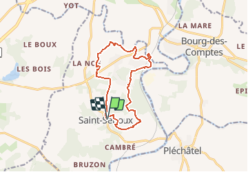
Trail Walking of 12.1 km to be discovered at Brittany, Ille-et-Vilaine, Saint-Senoux. This trail is proposed by chasle.
Description
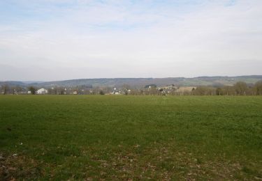
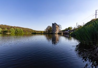
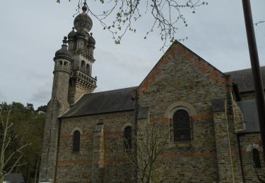
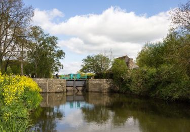
Cette randonnée, au départ de la place de l’église de Saint-Senoux, offre une belle diversité de paysages, boisements (dont une partie classée ZNIEFF, le bois de la Molière), bocage et cours d’eau, ainsi que de jolis panoramas sur les vallées du Canut et de la Vilaine (ZNIEFF: Zone Naturelle d’Intérêt Ecologique Faunistique et Floristique). Ce territoire, le bien nommé Pays des Vallons de Vilaine, propose une topographie accidentée, quasi unique dans le département, qui ravira les amateurs de randonnée. Le circuit de La Trotinais totalise en effet 320 mètres de dénivelé positif cumulé. Le bourg de Saint-Senoux et son église paroissiale Saint-Abdon (XIXème siècle) ainsi que les hameaux de La Trotinais et La Fiolais valent le coup d’œil. Retrouvez le circuit sur le site du Tourisme en haute-Bretagne Ille-et-Vilaine. ou sur le site «balades.bretagne35.com» du Comité départemental du Tourisme Haute Bretagne Ille-et-Vilaine.
Positioning
Comments
Trails nearby
![Trail On foot Pléchâtel - Circuit de Mainténiac - Photo](https://media.geolcdn.com/t/375/260/7fb5ae18-f1db-43e6-a6e1-b87dc82d549d.jpeg&format=jpg&maxdim=2)
![On foot On foot](https://static1.geolcdn.com/sitytour/trail-icons/100.png)
On foot
![](/images/other/stat-length.png)
![](https://static1.geolcdn.com/siteimages/upload/files/16400158638029165_repeat_loop_refresh_sync_direction_icon.png)
![Trail On foot Pléchâtel - Circuit de la Croix des Jeunes - Photo](https://media.geolcdn.com/t/375/260/9e8b4b4f-d301-4624-a79a-f0749db2dfcc.jpeg&format=jpg&maxdim=2)
![On foot On foot](https://static1.geolcdn.com/sitytour/trail-icons/100.png)
On foot
![](/images/other/stat-length.png)
![](https://static1.geolcdn.com/siteimages/upload/files/16400158638029165_repeat_loop_refresh_sync_direction_icon.png)
![Trail On foot Bourg-des-Comptes - Circuit des Biches - Photo](https://media.geolcdn.com/t/375/260/5a6882f1-47ea-4e81-ab0e-66797e6d831a.jpeg&format=jpg&maxdim=2)
![On foot On foot](https://static1.geolcdn.com/sitytour/trail-icons/100.png)
On foot
![](/images/other/stat-length.png)
![](https://static1.geolcdn.com/siteimages/upload/files/16400158638029165_repeat_loop_refresh_sync_direction_icon.png)
![Trail On foot Guichen - Le moulin de la Bouëxière - Photo](https://media.geolcdn.com/t/375/260/67ed7694-dc2d-46f9-bbeb-c597511af91a.jpeg&format=jpg&maxdim=2)
![On foot On foot](https://static1.geolcdn.com/sitytour/trail-icons/100.png)
On foot
![](/images/other/stat-length.png)
![](https://static1.geolcdn.com/siteimages/upload/files/16400158638029165_repeat_loop_refresh_sync_direction_icon.png)
![Trail On foot Guichen - La Locquenais - Photo](https://media.geolcdn.com/t/375/260/67ed7694-dc2d-46f9-bbeb-c597511af91a.jpeg&format=jpg&maxdim=2)
![On foot On foot](https://static1.geolcdn.com/sitytour/trail-icons/100.png)
On foot
![](/images/other/stat-length.png)
![](https://static1.geolcdn.com/siteimages/upload/files/16400158638029165_repeat_loop_refresh_sync_direction_icon.png)
![Trail On foot Saint-Senoux - Circuit de la Levée - Photo](https://media.geolcdn.com/t/375/260/9e8b4b4f-d301-4624-a79a-f0749db2dfcc.jpeg&format=jpg&maxdim=2)
![On foot On foot](https://static1.geolcdn.com/sitytour/trail-icons/100.png)
On foot
![](/images/other/stat-length.png)
![](https://static1.geolcdn.com/siteimages/upload/files/16400158638029165_repeat_loop_refresh_sync_direction_icon.png)
![Trail On foot Saint-Senoux - circuit de Cambertu - Photo](https://media.geolcdn.com/t/375/260/93b56c7a-45ee-41ec-9e8c-bf78f2aa3c2d.jpeg&format=jpg&maxdim=2)
![On foot On foot](https://static1.geolcdn.com/sitytour/trail-icons/100.png)
On foot
![](/images/other/stat-length.png)
![](https://static1.geolcdn.com/siteimages/upload/files/16400158638029165_repeat_loop_refresh_sync_direction_icon.png)
![Trail On foot Saint-Senoux - Circuit des Pervenches - Photo](https://media.geolcdn.com/t/375/260/93b56c7a-45ee-41ec-9e8c-bf78f2aa3c2d.jpeg&format=jpg&maxdim=2)
![On foot On foot](https://static1.geolcdn.com/sitytour/trail-icons/100.png)
On foot
![](/images/other/stat-length.png)
![](https://static1.geolcdn.com/siteimages/upload/files/16400158638029165_repeat_loop_refresh_sync_direction_icon.png)
![Trail On foot Saint-Senoux - Circuit de la Trotinais - Photo](https://media.geolcdn.com/t/375/260/467b66a9-2355-44bb-b47d-644a46c89128.jpeg&format=jpg&maxdim=2)
![On foot On foot](https://static1.geolcdn.com/sitytour/trail-icons/100.png)
On foot
![](/images/other/stat-length.png)
![](https://static1.geolcdn.com/siteimages/upload/files/16400158638029165_repeat_loop_refresh_sync_direction_icon.png)