![](/images/other/stat-length.png)
![Trail Walking Tautavel - Tautavel - Tour Del Far - Photo](https://media.geolcdn.com/t/1900/400/ext.pjpeg?maxdim=2&url=https%3A%2F%2Fstatic1.geolcdn.com%2Fsiteimages%2Fupload%2Ffiles%2F1553511878bg_sport_marche.png)
Tautavel - Tour Del Far
ThonyM
User
![Length](/images/other/stat-length.png)
Length
71 km
![Max alt](https://static1.geolcdn.com/siteimages/upload/files/1508320355ic_sort_altitude_max_24dp.png)
Max alt
481 m
![Uphill gradient](https://static1.geolcdn.com/siteimages/upload/files/1508320355ic_sort_den_pos_24dp.png)
Uphill gradient
1485 m
![Km-Effort](/images/other/stat-length.png)
Km-Effort
90 km
![Min alt](https://static1.geolcdn.com/siteimages/upload/files/1508320355ic_sort_altitude_min_24dp.png)
Min alt
51 m
![Downhill gradient](https://static1.geolcdn.com/siteimages/upload/files/1508320355ic_sort_den_neg_24dp.png)
Downhill gradient
1254 m
![Boucle](https://static1.geolcdn.com/siteimages/upload/files/16400158638029165_repeat_loop_refresh_sync_direction_icon.png)
Boucle
No
Creation date :
2016-12-08 00:00:00.0
Updated on :
2016-12-08 00:00:00.0
![Walking](https://static1.geolcdn.com/sitytour/trail-icons/101.png)
5h53
Difficulty : Medium
![Scan this QR Code to open this trail in the SityTrail application](https://capi.geolives.com/qq0zvz2zws4bq2lad0pu/sitytour/trails/669969/qr.png?size=200)
FREE GPS app for hiking
About
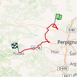
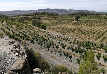
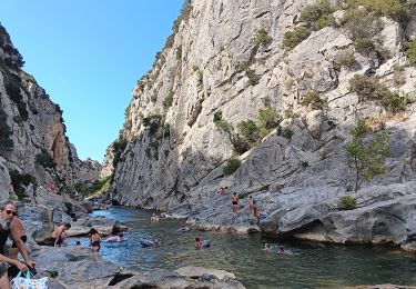
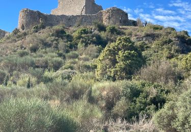
Trail Walking of 71 km to be discovered at Occitania, Pyrénées-Orientales, Tautavel. This trail is proposed by ThonyM.
Description
Une randonnée DNS le brouillard mais quand même agréable. Pas de difficulté majeure. Attention Xu pierres et racines glissantes par temps de pluie ou de brouillard
Positioning
Country:
France
Region :
Occitania
Department/Province :
Pyrénées-Orientales
Municipality :
Tautavel
Location:
Unknown
Start:(Dec)
Start:(UTM)
479649 ; 4740655 (31T) N.
Comments
Trails nearby
![Trail Walking Tautavel - Tautavel chemin des bacs - Photo](https://media.geolcdn.com/t/375/260/4347d338-087b-4ab9-a23d-b90780ad37c2.jpg&format=jpg&maxdim=2)
![Walking Walking](https://static1.geolcdn.com/sitytour/trail-icons/101.png)
Tautavel chemin des bacs
Walking
Easy
(3)
Tautavel,
Occitania,
Pyrénées-Orientales,
France
![](/images/other/stat-length.png)
9.5 km | 12.4 km-effort
2h 30min
![](https://static1.geolcdn.com/siteimages/upload/files/16400158638029165_repeat_loop_refresh_sync_direction_icon.png)
Yes
![Trail Walking Vingrau - Chemin des Contrebandiers Vingrau variante - Photo](https://media.geolcdn.com/t/375/260/ext.jpg?maxdim=2&url=https%3A%2F%2Fservices.sitytrail.com%2FGeolivesWS%2FDownloadMedia.ashx%3FTrailID%3D422545%26Media%3Dfix__20140613113149.jpg)
![Walking Walking](https://static1.geolcdn.com/sitytour/trail-icons/101.png)
Chemin des Contrebandiers Vingrau variante
Walking
Medium
(2)
Vingrau,
Occitania,
Pyrénées-Orientales,
France
![](/images/other/stat-length.png)
10.4 km | 16 km-effort
3h 30min
![](https://static1.geolcdn.com/siteimages/upload/files/16400158638029165_repeat_loop_refresh_sync_direction_icon.png)
Yes
![Trail Walking Vingrau - Vingrau - Photo](https://media.geolcdn.com/t/375/260/59157f3c-9cda-4a07-bd09-42a8a8a018aa.jpg&format=jpg&maxdim=2)
![Walking Walking](https://static1.geolcdn.com/sitytour/trail-icons/101.png)
Vingrau
Walking
Medium
Vingrau,
Occitania,
Pyrénées-Orientales,
France
![](/images/other/stat-length.png)
15.5 km | 22 km-effort
4h 20min
![](https://static1.geolcdn.com/siteimages/upload/files/16400158638029165_repeat_loop_refresh_sync_direction_icon.png)
Yes
![Trail Walking Estagel - ESTAGEL Chapelle St Laurent MARDI FAIT - Photo](https://media.geolcdn.com/t/375/260/14957312-1764-401b-980d-e06b9de6af18.jpg&format=jpg&maxdim=2)
![Walking Walking](https://static1.geolcdn.com/sitytour/trail-icons/101.png)
ESTAGEL Chapelle St Laurent MARDI FAIT
Walking
Medium
(1)
Estagel,
Occitania,
Pyrénées-Orientales,
France
![](/images/other/stat-length.png)
12.2 km | 16.9 km-effort
3h 26min
![](https://static1.geolcdn.com/siteimages/upload/files/16400158638029165_repeat_loop_refresh_sync_direction_icon.png)
Yes
![Trail Walking Cases-de-Pène - 2023-08-01_12h04m36_SityTrail - 3754591 - cases-de-pene-x-detour-et-retour - Photo](https://media.geolcdn.com/t/375/260/883a1714-3990-4d53-92ac-a82da8ee9827.jpg&format=jpg&maxdim=2)
![Walking Walking](https://static1.geolcdn.com/sitytour/trail-icons/101.png)
2023-08-01_12h04m36_SityTrail - 3754591 - cases-de-pene-x-detour-et-retour
Walking
Medium
Cases-de-Pène,
Occitania,
Pyrénées-Orientales,
France
![](/images/other/stat-length.png)
5 km | 6.1 km-effort
1h 23min
![](https://static1.geolcdn.com/siteimages/upload/files/16400158638029165_repeat_loop_refresh_sync_direction_icon.png)
Yes
![Trail Walking Tautavel - les gorges . tautavel par les vignes .. retour par la vallée - Photo](https://media.geolcdn.com/t/375/260/f5cf1c3a-e9df-4e15-9388-551099a87371.jpg&format=jpg&maxdim=2)
![Walking Walking](https://static1.geolcdn.com/sitytour/trail-icons/101.png)
les gorges . tautavel par les vignes .. retour par la vallée
Walking
Easy
Tautavel,
Occitania,
Pyrénées-Orientales,
France
![](/images/other/stat-length.png)
8.2 km | 11 km-effort
2h 57min
![](https://static1.geolcdn.com/siteimages/upload/files/16400158638029165_repeat_loop_refresh_sync_direction_icon.png)
No
![Trail Walking Paziols - paziols 19 kms - Photo](https://media.geolcdn.com/t/375/260/ddaac51d-e934-4f1b-ab1b-521ca7bf9769.jpg&format=jpg&maxdim=2)
![Walking Walking](https://static1.geolcdn.com/sitytour/trail-icons/101.png)
![Trail Walking Paziols - Paziols château d’aguilra - Photo](https://media.geolcdn.com/t/375/260/fa47ac32-1f20-4f2f-bc41-046989712c5d.jpg&format=jpg&maxdim=2)
![Walking Walking](https://static1.geolcdn.com/sitytour/trail-icons/101.png)
Paziols château d’aguilra
Walking
Very easy
Paziols,
Occitania,
Aude,
France
![](/images/other/stat-length.png)
15.1 km | 18.8 km-effort
4h 4min
![](https://static1.geolcdn.com/siteimages/upload/files/16400158638029165_repeat_loop_refresh_sync_direction_icon.png)
Yes
![Trail Walking Tautavel - TAUTAVEL la Tour del Far A/R - Photo](https://media.geolcdn.com/t/375/260/7315cb9e-35b2-46c7-8732-adf6f85e9975.jpg&format=jpg&maxdim=2)
![Walking Walking](https://static1.geolcdn.com/sitytour/trail-icons/101.png)
TAUTAVEL la Tour del Far A/R
Walking
Medium
Tautavel,
Occitania,
Pyrénées-Orientales,
France
![](/images/other/stat-length.png)
6.3 km | 11.4 km-effort
3h 55min
![](https://static1.geolcdn.com/siteimages/upload/files/16400158638029165_repeat_loop_refresh_sync_direction_icon.png)
Yes