Trail Other activity Amiens - Picardie - Ligne 305 - Saint-Roch - Frévent par Canaples et Doullens (Section St-Roch Bouquemaison) - Photo

Picardie - Ligne 305 - Saint-Roch - Frévent par Canaples et Doullens (Section St-Roch Bouquemaison)

 mich54
mich54

User

© OpenStreetMap contributors
Length
Length
52 km
Max alt
Max alt
158 m
Uphill gradient
Uphill gradient
539 m
Km-Effort
Km-Effort  
59 km
Min alt
Min alt
18 m
Downhill gradient
Downhill gradient
424 m
Boucle
Boucle
No
Creation date :
2016-12-03 00:00:00.0
Updated on :
2016-12-03 00:00:00.0

(0 Reviews)

Other activity
Other activity
5m
Difficulty : Unknown

Scan this QR Code to open this trail in the SityTrail application

FREE GPS app for hiking

Logo SityTrail SityTrail

IGN / Geographical institutes

Download SityTrail from the App Store Download SityTrail from Google Play

Logo SityTrail SityTrail World

The world is yours!

Download SityTrail from the App Store Download SityTrail from Google Play Download SityTrail on Huawei AppGallery

About

Trail Other activity of 52 km to be discovered at Hauts-de-France, Somme, Amiens. This trail is proposed by mich54.

Description

La ligne de Saint-Roch à Frévent est une ligne de chemin de fer non électrifiée à voie unique qui relie la gare de Saint-Roch (Somme) à celle de Frévent sur la ligne de Fives à Abbeville. Elle est déposée sur une partie de son parcours, entre Frévent et Doullens.

Elle constitue la ligne no 305 0001 du réseau ferré national.(Source Wikipédia)

Elevation profile

Positioning

Country:
France
Region :
Hauts-de-France
Department/Province :
Somme
Municipality :
Amiens
Location:
Unknown
Start:(UTM)
448487 ; 5527017 (31U) N.

Trails nearby

Trail Mountain bike Amiens - Dury chisel  - Photo
Mountain bike
jjeletufe

Mountain bike

Easy
(1)
Amiens, Hauts-de-France, Somme, France
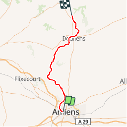
21 km | 24 km-effort
1h 4min
Yes
Trail Walking Amiens - 2016 05 01 - Photo
Walking
lr80

Walking

Difficult
(1)
Amiens, Hauts-de-France, Somme, France
42 km | 46 km-effort
7h 25min
Yes
Trail Walking Amiens - amiens - Photo
Walking
dehemjacques

Walking

Easy
(2)
Amiens, Hauts-de-France, Somme, France
12.7 km | 13.8 km-effort
2h 12min
No
Trail Walking Amiens - 2013-05-04 - Photo
Walking
lr80

Walking

Medium
(1)
Amiens, Hauts-de-France, Somme, France
42 km | 47 km-effort
6h 45min
Yes
Trail Walking Amiens - petite balade nocturne a Amiens - Photo
Walking
GUIDE
stef789

Walking

Easy
Amiens, Hauts-de-France, Somme, France
5 km | 5.6 km-effort
1h 23min
Yes
Trail Walking Amiens - amiens camon amiens par les hortillonnages - Photo
Walking
GUIDE
stef789

Walking

Very easy
Amiens, Hauts-de-France, Somme, France
8.4 km | 9.2 km-effort
2h 12min
Yes
Trail Electric bike Amiens - Amiens Gouy les groseilliers  - Photo
Electric bike
ORTAX

Electric bike

Difficult
Amiens, Hauts-de-France, Somme, France
48 km | 0 m-effort
3h 2min
No
Trail Walking Amiens - Circuit Sainte-Aragone - Amiens - Photo
Walking
tracegps

Walking

Medium
Amiens, Hauts-de-France, Somme, France
12.1 km | 13.1 km-effort
3h 0min
Yes
Trail Walking Amiens - Circuit de la Canardière - Amiens - Photo
Walking
tracegps

Walking

Difficult
Amiens, Hauts-de-France, Somme, France
14.2 km | 15.2 km-effort
3h 30min
Yes


Close
My subscriptions