Trail Motor Gauville - RANDO TELETHON 2016 APRES MIDI - Photo

RANDO TELETHON 2016 APRES MIDI

© OpenStreetMap contributors
Length
Length
73 km
Max alt
Max alt
226 m
Uphill gradient
Uphill gradient
962 m
Km-Effort
Km-Effort  
86 km
Min alt
Min alt
124 m
Downhill gradient
Downhill gradient
963 m
Boucle
Boucle
Yes
Creation date :
2016-12-01 00:00:00.0
Updated on :
2016-12-01 00:00:00.0

(0 Reviews)

Motor
Motor
5h00
Difficulty : Easy

Scan this QR Code to open this trail in the SityTrail application

FREE GPS app for hiking

Logo SityTrail SityTrail

IGN / Geographical institutes

Download SityTrail from the App Store Download SityTrail from Google Play

Logo SityTrail SityTrail World

The world is yours!

Download SityTrail from the App Store Download SityTrail from Google Play Download SityTrail on Huawei AppGallery

About

Trail Motor of 73 km to be discovered at Hauts-de-France, Somme, Gauville. This trail is proposed by association.

Description

RANDO  TELETHON APRES MIDI 2016

Elevation profile

Positioning

Country:
France
Region :
Hauts-de-France
Department/Province :
Somme
Municipality :
Gauville
Location:
Unknown
Start:(UTM)
413114 ; 5515050 (31U) N.

Trails nearby

Trail On foot Aumale - Le Bois Robin - Photo
On foot
GUIDE+

On foot

Easy
Aumale, Normandy, Seine-Maritime, France
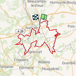
7.2 km | 8.8 km-effort
1h 59min
Yes
Trail On foot Aumale - Le Beau Soleil - Photo
On foot
GUIDE+

On foot

Easy
Aumale, Normandy, Seine-Maritime, France
9.8 km | 12.2 km-effort
2h 45min
Yes
Trail Equestrian Aumale - Le beau soleil N° 2 - Aumale  - Photo
Equestrian
tracegps

Equestrian

Medium
Aumale, Normandy, Seine-Maritime, France
10.8 km | 13.4 km-effort
2h 0min
Yes
Trail Mountain bike Aumale - Le beau soleil N° 2 - Aumale  - Photo
Mountain bike
tracegps

Mountain bike

Medium
Aumale, Normandy, Seine-Maritime, France
10.8 km | 13.4 km-effort
1h 0min
Yes
Trail Walking Aumale - Le beau soleil N° 2 - Aumale  - Photo
Walking
tracegps

Walking

Medium
Aumale, Normandy, Seine-Maritime, France
10.8 km | 13.4 km-effort
2h 40min
Yes
Trail Equestrian Haudricourt - La Lozière (N° 4)  - Haudricourt - Photo
Equestrian
tracegps

Equestrian

Medium
Haudricourt, Normandy, Seine-Maritime, France
11 km | 13.9 km-effort
1h 30min
Yes
Trail Mountain bike Haudricourt - La Lozière (N° 4)  - Haudricourt - Photo
Mountain bike
tracegps

Mountain bike

Easy
Haudricourt, Normandy, Seine-Maritime, France
11 km | 13.9 km-effort
1h 0min
Yes
Trail Walking Haudricourt - La Lozière (N° 4)  - Haudricourt - Photo
Walking
tracegps

Walking

Medium
Haudricourt, Normandy, Seine-Maritime, France
11 km | 13.9 km-effort
2h 45min
Yes
Trail Equestrian Aumale - Le bois Robin - Aumale - Photo
Equestrian
tracegps

Equestrian

Easy
Aumale, Normandy, Seine-Maritime, France
8.4 km | 10.1 km-effort
1h 19min
Yes


Close
My subscriptions