![](/images/other/stat-length.png)
![Trail Walking Beaune - À travers quelques Premiers Crus de Beaune - Photo](https://media.geolcdn.com/t/1900/400/ext.pjpeg?maxdim=2&url=https%3A%2F%2Fstatic1.geolcdn.com%2Fsiteimages%2Fupload%2Ffiles%2F1553511878bg_sport_marche.png)
À travers quelques Premiers Crus de Beaune
micheldutilleul
User
![Length](/images/other/stat-length.png)
Length
6.6 km
![Max alt](https://static1.geolcdn.com/siteimages/upload/files/1508320355ic_sort_altitude_max_24dp.png)
Max alt
313 m
![Uphill gradient](https://static1.geolcdn.com/siteimages/upload/files/1508320355ic_sort_den_pos_24dp.png)
Uphill gradient
113 m
![Km-Effort](/images/other/stat-length.png)
Km-Effort
8.1 km
![Min alt](https://static1.geolcdn.com/siteimages/upload/files/1508320355ic_sort_altitude_min_24dp.png)
Min alt
217 m
![Downhill gradient](https://static1.geolcdn.com/siteimages/upload/files/1508320355ic_sort_den_neg_24dp.png)
Downhill gradient
113 m
![Boucle](https://static1.geolcdn.com/siteimages/upload/files/16400158638029165_repeat_loop_refresh_sync_direction_icon.png)
Boucle
Yes
Creation date :
2016-11-17 00:00:00.0
Updated on :
2016-11-17 00:00:00.0
![Walking](https://static1.geolcdn.com/sitytour/trail-icons/101.png)
1h46
Difficulty : Easy
![Scan this QR Code to open this trail in the SityTrail application](https://capi.geolives.com/qq0zvz2zws4bq2lad0pu/sitytour/trails/661401/qr.png?size=200)
FREE GPS app for hiking
About
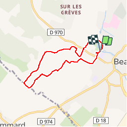
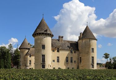
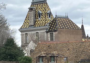
Trail Walking of 6.6 km to be discovered at Bourgogne-Franche-Comté, Côte-d'Or, Beaune. This trail is proposed by micheldutilleul.
Description
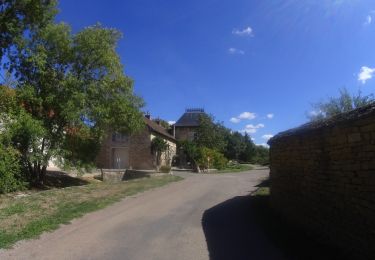
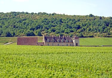
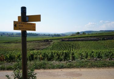
Circuit en boucle facile permettant de cheminer parmi le vignoble beaunois au sud de la Ville. Circuit n°12 de Beaune-Tourisme.
Positioning
Country:
France
Region :
Bourgogne-Franche-Comté
Department/Province :
Côte-d'Or
Municipality :
Beaune
Location:
Unknown
Start:(Dec)
Start:(UTM)
638928 ; 5209694 (31T) N.
Comments
Trails nearby
![Mountain bike Mountain bike](https://static1.geolcdn.com/sitytour/trail-icons/202.png)
activity_9584608261
Mountain bike
Difficult
Meursault,
Bourgogne-Franche-Comté,
Côte-d'Or,
France
![](/images/other/stat-length.png)
24 km | 33 km-effort
2h 17min
![](https://static1.geolcdn.com/siteimages/upload/files/16400158638029165_repeat_loop_refresh_sync_direction_icon.png)
Yes
![Trail On foot Bouze-lès-Beaune - Sentier des Biques - Photo](https://media.geolcdn.com/t/375/260/06c9d9a9-fd34-4051-b316-449f9ce73b66.jpeg&format=jpg&maxdim=2)
![On foot On foot](https://static1.geolcdn.com/sitytour/trail-icons/100.png)
Sentier des Biques
On foot
Easy
Bouze-lès-Beaune,
Bourgogne-Franche-Comté,
Côte-d'Or,
France
![](/images/other/stat-length.png)
14.6 km | 18.5 km-effort
4h 12min
![](https://static1.geolcdn.com/siteimages/upload/files/16400158638029165_repeat_loop_refresh_sync_direction_icon.png)
Yes
![Trail On foot Beaune - Montagne de Beaune - Photo](https://media.geolcdn.com/t/375/260/2ce37b1d-cf91-4f38-9b9d-7d5ffcfaf544.jpeg&format=jpg&maxdim=2)
![On foot On foot](https://static1.geolcdn.com/sitytour/trail-icons/100.png)
Montagne de Beaune
On foot
Easy
Beaune,
Bourgogne-Franche-Comté,
Côte-d'Or,
France
![](/images/other/stat-length.png)
9.7 km | 13.1 km-effort
2h 58min
![](https://static1.geolcdn.com/siteimages/upload/files/16400158638029165_repeat_loop_refresh_sync_direction_icon.png)
Yes
![Trail On foot Savigny-lès-Beaune - Chemin des Vignes - Photo](https://media.geolcdn.com/t/375/260/6a798f36-e51f-4b63-b003-ccd2a5c5a35b.jpeg&format=jpg&maxdim=2)
![On foot On foot](https://static1.geolcdn.com/sitytour/trail-icons/100.png)
Chemin des Vignes
On foot
Easy
Savigny-lès-Beaune,
Bourgogne-Franche-Comté,
Côte-d'Or,
France
![](/images/other/stat-length.png)
11.6 km | 16.6 km-effort
3h 45min
![](https://static1.geolcdn.com/siteimages/upload/files/16400158638029165_repeat_loop_refresh_sync_direction_icon.png)
Yes
![Trail On foot Beaune - Premiers Crus de Beaune - Photo](https://media.geolcdn.com/t/375/260/913953a5-6f34-41b7-9ee9-5a81c874e58e.jpeg&format=jpg&maxdim=2)
![On foot On foot](https://static1.geolcdn.com/sitytour/trail-icons/100.png)
Premiers Crus de Beaune
On foot
Easy
Beaune,
Bourgogne-Franche-Comté,
Côte-d'Or,
France
![](/images/other/stat-length.png)
6.2 km | 7.7 km-effort
1h 44min
![](https://static1.geolcdn.com/siteimages/upload/files/16400158638029165_repeat_loop_refresh_sync_direction_icon.png)
Yes
![Trail Walking Aloxe-Corton - Alox, Corton - Photo](https://media.geolcdn.com/t/375/260/e85760f3-3b7d-4088-a5df-3b78fdaabc0f.jpg&format=jpg&maxdim=2)
![Walking Walking](https://static1.geolcdn.com/sitytour/trail-icons/101.png)
Alox, Corton
Walking
Medium
Aloxe-Corton,
Bourgogne-Franche-Comté,
Côte-d'Or,
France
![](/images/other/stat-length.png)
21 km | 28 km-effort
4h 37min
![](https://static1.geolcdn.com/siteimages/upload/files/16400158638029165_repeat_loop_refresh_sync_direction_icon.png)
Yes
![Trail Walking Bouze-lès-Beaune - Bouze les Beaune Le sentier des Biques page 124 - Photo](https://media.geolcdn.com/t/375/260/ext.jpg?maxdim=2&url=https%3A%2F%2Fstatic1.geolcdn.com%2Fsiteimages%2Fupload%2Ffiles%2F1553511878bg_sport_marche.png)
![Walking Walking](https://static1.geolcdn.com/sitytour/trail-icons/101.png)
Bouze les Beaune Le sentier des Biques page 124
Walking
Very difficult
(1)
Bouze-lès-Beaune,
Bourgogne-Franche-Comté,
Côte-d'Or,
France
![](/images/other/stat-length.png)
17.4 km | 23 km-effort
5h 8min
![](https://static1.geolcdn.com/siteimages/upload/files/16400158638029165_repeat_loop_refresh_sync_direction_icon.png)
Yes
![Trail Walking Savigny-lès-Beaune - Savigny - Combe Portaut - Photo](https://media.geolcdn.com/t/375/260/003198ee-e4fc-487c-8a4c-424848175058.jpg&format=jpg&maxdim=2)
![Walking Walking](https://static1.geolcdn.com/sitytour/trail-icons/101.png)
Savigny - Combe Portaut
Walking
Medium
Savigny-lès-Beaune,
Bourgogne-Franche-Comté,
Côte-d'Or,
France
![](/images/other/stat-length.png)
16.6 km | 22 km-effort
3h 49min
![](https://static1.geolcdn.com/siteimages/upload/files/16400158638029165_repeat_loop_refresh_sync_direction_icon.png)
Yes
![Trail Walking Meursault - Huttopia - Meursault - Photo](https://media.geolcdn.com/t/375/260/49f33ddd-6f70-431c-8430-f723e5e21e3a.jpg&format=jpg&maxdim=2)
![Walking Walking](https://static1.geolcdn.com/sitytour/trail-icons/101.png)
Huttopia - Meursault
Walking
Very easy
(1)
Meursault,
Bourgogne-Franche-Comté,
Côte-d'Or,
France
![](/images/other/stat-length.png)
3.8 km | 4.4 km-effort
58min
![](https://static1.geolcdn.com/siteimages/upload/files/16400158638029165_repeat_loop_refresh_sync_direction_icon.png)
Yes