Trail Walking Saint-Saturnin - Chadrat_Montagne_Serre - Photo
 jagarnier
jagarnier

User GUIDE

© OpenStreetMap contributors
Length
Length
10.2 km
Max alt
Max alt
735 m
Uphill gradient
Uphill gradient
249 m
Km-Effort
Km-Effort  
13.5 km
Min alt
Min alt
595 m
Downhill gradient
Downhill gradient
249 m
Boucle
Boucle
Yes
Creation date :
2016-11-16 00:00:00.0
Updated on :
2023-12-10 07:12:02.611

(1 Reviews)

Walking
Walking
3h00
Difficulty : Medium

Scan this QR Code to open this trail in the SityTrail application

FREE GPS app for hiking

Logo SityTrail SityTrail

IGN / Geographical institutes

Download SityTrail from the App Store Download SityTrail from Google Play

Logo SityTrail SityTrail World

The world is yours!

Download SityTrail from the App Store Download SityTrail from Google Play Download SityTrail on Huawei AppGallery

About

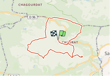
Trail Walking of 10.2 km to be discovered at Auvergne-Rhône-Alpes, Puy-de-Dôme, Saint-Saturnin. This trail is proposed by jagarnier.

Description

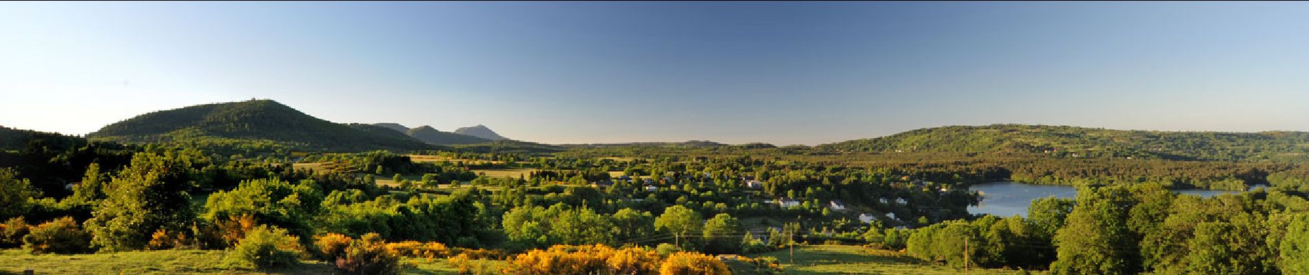
Sur le flanc sud de la montagne de la Serre, cette randonnée nous propose de belles perspectives sur les vallées de la Monne et de l'Auzon. Le site de Montépo vaut le détour. Vous pourrez observer les oiseaux migrateurs sur l'ancien site de la LPO au milieu du plateau de la Serre. Vous terminerez par la traverser de Chadrat avec ses maisons de pierre, ses fontaines et un lavoir.

Elevation profile

Photos

Positioning

Country:
France
Region :
Auvergne-Rhône-Alpes
Department/Province :
Puy-de-Dôme
Municipality :
Saint-Saturnin
Location:
Unknown
Start:(UTM)
505879 ; 5057969 (31T) N.

Comments

Please log in to post a review or rate the element


Trails nearby

Trail Walking Romagnat - Le Puy Giroux près d'Opme - Photo
Walking
tracegps

Walking

Easy
(1)
Romagnat, Auvergne-Rhône-Alpes, Puy-de-Dôme, France
6.6 km | 9.2 km-effort
1h 45min
Yes
Trail On foot Saint-Saturnin - Randol - Photo
On foot
GUIDE+

On foot

Easy
(1)
Saint-Saturnin, Auvergne-Rhône-Alpes, Puy-de-Dôme, France
7.8 km | 10.6 km-effort
2h 24min
Yes
Trail On foot Saint-Saturnin - Les Cirques de longevette et des Cotes - Photo
On foot
GUIDE+

On foot

Easy
Saint-Saturnin, Auvergne-Rhône-Alpes, Puy-de-Dôme, France
5.4 km | 7.1 km-effort
1h 37min
Yes
Trail On foot Saint-Amant-Tallende - Le Puy de Peyronere - Photo
On foot
GUIDE+

On foot

Easy
Saint-Amant-Tallende, Auvergne-Rhône-Alpes, Puy-de-Dôme, France
9.5 km | 13 km-effort
2h 57min
Yes
Trail On foot Saint-Genès-Champanelle - Nadaillat - Photo
On foot
GUIDE+

On foot

Easy
Saint-Genès-Champanelle, Auvergne-Rhône-Alpes, Puy-de-Dôme, France
6.6 km | 9.3 km-effort
2h 7min
Yes
Trail On foot Chanonat - Le Crest - Photo
On foot
GUIDE+

On foot

Easy
Chanonat, Auvergne-Rhône-Alpes, Puy-de-Dôme, France
10.7 km | 14.7 km-effort
3h 20min
Yes
Trail On foot Chanonat - Le Puy de Jussat - Photo
On foot
GUIDE+

On foot

Easy
Chanonat, Auvergne-Rhône-Alpes, Puy-de-Dôme, France
4.7 km | 6.8 km-effort
1h 32min
Yes
Trail Walking Saint-Saturnin - St saturnin - Photo
Walking
guy63

Walking

Very easy
(1)
Saint-Saturnin, Auvergne-Rhône-Alpes, Puy-de-Dôme, France
15.7 km | 21 km-effort
4h 29min
Yes
Trail Walking Ceyrat - Les trois moulins - Ceyrat - Photo
Walking
tracegps

Walking

Difficult
(1)
Ceyrat, Auvergne-Rhône-Alpes, Puy-de-Dôme, France
21 km | 28 km-effort
6h 0min
Yes


Close
My subscriptions