![](/images/other/stat-length.png)
![Trail Other activity Salazie - LaR. Rando 1 Piton d'ANCHAIN (de Hell Bourg) - Photo](https://media.geolcdn.com/t/1900/400/ext.pjpeg?maxdim=2&url=https%3A%2F%2Fstatic1.geolcdn.com%2Fsiteimages%2Fupload%2Ffiles%2F1545311037marcheuse_200dpi.jpg)
LaR. Rando 1 Piton d'ANCHAIN (de Hell Bourg)
ffffff
User
![Length](/images/other/stat-length.png)
Length
11.3 km
![Max alt](https://static1.geolcdn.com/siteimages/upload/files/1508320355ic_sort_altitude_max_24dp.png)
Max alt
1352 m
![Uphill gradient](https://static1.geolcdn.com/siteimages/upload/files/1508320355ic_sort_den_pos_24dp.png)
Uphill gradient
994 m
![Km-Effort](/images/other/stat-length.png)
Km-Effort
24 km
![Min alt](https://static1.geolcdn.com/siteimages/upload/files/1508320355ic_sort_altitude_min_24dp.png)
Min alt
690 m
![Downhill gradient](https://static1.geolcdn.com/siteimages/upload/files/1508320355ic_sort_den_neg_24dp.png)
Downhill gradient
783 m
![Boucle](https://static1.geolcdn.com/siteimages/upload/files/16400158638029165_repeat_loop_refresh_sync_direction_icon.png)
Boucle
No
Creation date :
2016-11-10 00:00:00.0
Updated on :
2016-11-10 00:00:00.0
![Other activity](https://static1.geolcdn.com/sitytour/trail-icons/900.png)
1h40
Difficulty : Unknown
![Scan this QR Code to open this trail in the SityTrail application](https://capi.geolives.com/qq0zvz2zws4bq2lad0pu/sitytour/trails/658395/qr.png?size=200)
FREE GPS app for hiking
About
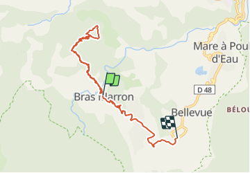
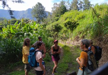
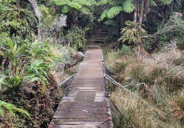
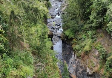
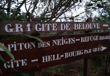
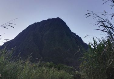
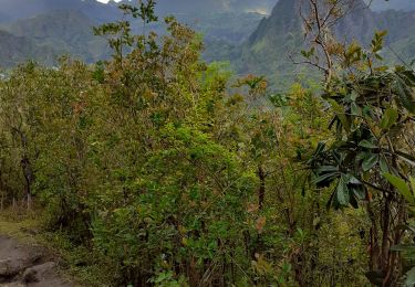
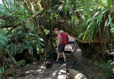
Trail Other activity of 11.3 km to be discovered at Réunion, Unknown, Salazie. This trail is proposed by ffffff.
Description
Rother dit D 760m 4h45 A/R du Parking.
ICI le matin,la descente EN du Relais es gouverneurs au Parking (3,5km = 40mn~) NB : cette distance a été ajoutée, en correction, sur le tracé de RETOUR
Positioning
Country:
France
Region :
Réunion
Department/Province :
Unknown
Municipality :
Salazie
Location:
Unknown
Start:(Dec)
Start:(UTM)
344297 ; 7670759 (40K) S.
Comments
Trails nearby
![Trail Walking Salazie - mare à poules d'eau - Photo](https://media.geolcdn.com/t/375/260/f233e327-af89-4e51-8952-a42deb7b065c.jpg&format=jpg&maxdim=2)
![Walking Walking](https://static1.geolcdn.com/sitytour/trail-icons/101.png)
mare à poules d'eau
Walking
Very easy
(1)
Salazie,
Réunion,
Unknown,
France
![](/images/other/stat-length.png)
2.5 km | 3.2 km-effort
1h 23min
![](https://static1.geolcdn.com/siteimages/upload/files/16400158638029165_repeat_loop_refresh_sync_direction_icon.png)
Yes
![Trail Walking Salazie - Trou de Fer par le refuge de Belouve. - Photo](https://media.geolcdn.com/t/375/260/e928c1d8-2457-4a87-a207-09d9da2e6f6a.jpg&format=jpg&maxdim=2)
![Walking Walking](https://static1.geolcdn.com/sitytour/trail-icons/101.png)
Trou de Fer par le refuge de Belouve.
Walking
Medium
Salazie,
Réunion,
Unknown,
France
![](/images/other/stat-length.png)
10 km | 13.5 km-effort
4h 27min
![](https://static1.geolcdn.com/siteimages/upload/files/16400158638029165_repeat_loop_refresh_sync_direction_icon.png)
Yes
![Trail Walking Salazie - tour du piton maillot - rivière du mat - Photo](https://media.geolcdn.com/t/375/260/b0283353-1556-4e58-b3a9-10ea62f2ed93.jpg&format=jpg&maxdim=2)
![Walking Walking](https://static1.geolcdn.com/sitytour/trail-icons/101.png)
tour du piton maillot - rivière du mat
Walking
Medium
Salazie,
Réunion,
Unknown,
France
![](/images/other/stat-length.png)
12.5 km | 21 km-effort
5h 42min
![](https://static1.geolcdn.com/siteimages/upload/files/16400158638029165_repeat_loop_refresh_sync_direction_icon.png)
Yes
![Trail On foot Salazie - Sentier du Trou de Fer - Photo](https://media.geolcdn.com/t/375/260/c038aaf4-d20f-42ab-9ddd-e2e145d6cf22.jpeg&format=jpg&maxdim=2)
![On foot On foot](https://static1.geolcdn.com/sitytour/trail-icons/100.png)
Sentier du Trou de Fer
On foot
Easy
Salazie,
Réunion,
Unknown,
France
![](/images/other/stat-length.png)
4 km | 5.1 km-effort
1h 10min
![](https://static1.geolcdn.com/siteimages/upload/files/16400158638029165_repeat_loop_refresh_sync_direction_icon.png)
No
![Trail Walking Salazie - Piton d'Anchain - Photo](https://media.geolcdn.com/t/375/260/e4fe93b2-c12b-4594-ba67-cfbaedd38e68.jpg&format=jpg&maxdim=2)
![Walking Walking](https://static1.geolcdn.com/sitytour/trail-icons/101.png)
Piton d'Anchain
Walking
Difficult
Salazie,
Réunion,
Unknown,
France
![](/images/other/stat-length.png)
9.1 km | 19.3 km-effort
2h 48min
![](https://static1.geolcdn.com/siteimages/upload/files/16400158638029165_repeat_loop_refresh_sync_direction_icon.png)
Yes
![Trail Walking Salazie - hellbourg trou de fer aller retour - Photo](https://media.geolcdn.com/t/375/260/f25ac1e5-8b40-471d-9124-c73c0cd498ae.jpg&format=jpg&maxdim=2)
![Walking Walking](https://static1.geolcdn.com/sitytour/trail-icons/101.png)
hellbourg trou de fer aller retour
Walking
Difficult
Salazie,
Réunion,
Unknown,
France
![](/images/other/stat-length.png)
22 km | 37 km-effort
7h 14min
![](https://static1.geolcdn.com/siteimages/upload/files/16400158638029165_repeat_loop_refresh_sync_direction_icon.png)
No
![Trail Walking Saint-Benoît - Trou de fer 05/10/19 - Photo](https://media.geolcdn.com/t/375/260/e5527ee8-926b-48b9-9a90-e02a67c5d55f.jpg&format=jpg&maxdim=2)
![Walking Walking](https://static1.geolcdn.com/sitytour/trail-icons/101.png)
Trou de fer 05/10/19
Walking
Medium
Saint-Benoît,
Réunion,
Unknown,
France
![](/images/other/stat-length.png)
11 km | 14.2 km-effort
4h 40min
![](https://static1.geolcdn.com/siteimages/upload/files/16400158638029165_repeat_loop_refresh_sync_direction_icon.png)
Yes
![Trail Walking Salazie - Trpu de fer belouve depuis hellbourg - Photo](https://media.geolcdn.com/t/375/260/892a7e28-b4c3-43fd-a2b8-cc58d169f618.jpg&format=jpg&maxdim=2)
![Walking Walking](https://static1.geolcdn.com/sitytour/trail-icons/101.png)
Trpu de fer belouve depuis hellbourg
Walking
(1)
Salazie,
Réunion,
Unknown,
France
![](/images/other/stat-length.png)
17.4 km | 29 km-effort
7h 26min
![](https://static1.geolcdn.com/siteimages/upload/files/16400158638029165_repeat_loop_refresh_sync_direction_icon.png)
Yes
![Trail Walking Saint-Benoît - trou de fer - Photo](https://media.geolcdn.com/t/375/260/ext.jpg?maxdim=2&url=https%3A%2F%2Fservices.sitytrail.com%2FGeolivesWS%2FDownloadMedia.ashx%3FTrailID%3D398057%26Media%3Dfix__20150318134039.jpg)
![Walking Walking](https://static1.geolcdn.com/sitytour/trail-icons/101.png)
trou de fer
Walking
Medium
(1)
Saint-Benoît,
Réunion,
Unknown,
France
![](/images/other/stat-length.png)
13.6 km | 16.9 km-effort
2h 38min
![](https://static1.geolcdn.com/siteimages/upload/files/16400158638029165_repeat_loop_refresh_sync_direction_icon.png)
Yes