Trail Walking Rimbach-près-Masevaux - Ermensbach-Rouge Gazon - Photo
© OpenStreetMap contributors
Length
Length
18.6 km
Max alt
Max alt
1187 m
Uphill gradient
Uphill gradient
1055 m
Km-Effort
Km-Effort  
33 km
Min alt
Min alt
534 m
Downhill gradient
Downhill gradient
1057 m
Boucle
Boucle
Yes
Creation date :
2019-01-20 20:50:25.778
Updated on :
2019-01-20 20:50:25.81

(0 Reviews)

Walking
Walking
6h37
Difficulty : Difficult

Scan this QR Code to open this trail in the SityTrail application

FREE GPS app for hiking

Logo SityTrail SityTrail

IGN / Geographical institutes

Download SityTrail from the App Store Download SityTrail from Google Play

Logo SityTrail SityTrail World

The world is yours!

Download SityTrail from the App Store Download SityTrail from Google Play Download SityTrail on Huawei AppGallery

About

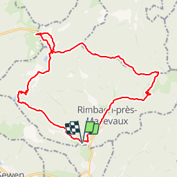
Trail Walking of 18.6 km to be discovered at Grand Est, Haut-Rhin, Rimbach-près-Masevaux. This trail is proposed by LaurentGILG.

Description

Ermensbach-Lacs de Neuweilher-Lac des Perches-Rouge Gazon-Rimbachkopf-Mittelrainkopf-Col de Rimpach-Ruchberg-Rimbach pres Masevaux.

Elevation profile

Points of interest

Point of interest Rimbach-près-Masevaux - Disque Bleu Lacs de Neuweiher - Photo
LaurentGILG
RIMBACH-PRÈS-MASEVAUX 
Point of interest Rimbach-près-Masevaux - Rectangle Bleu Lac des Perches - Photo
LaurentGILG
RIMBACH-PRÈS-MASEVAUX 
Point of interest Rimbach-près-Masevaux - Rectangle Bleu Rouge Gazon - Photo
LaurentGILG
RIMBACH-PRÈS-MASEVAUX 
Point of interest Storckensohn - Rectangle Rouge Blanc Rouge - Photo
LaurentGILG
Point of interest Storckensohn - Triangle Jaune Col des Perches - Photo
LaurentGILG
Point of interest Storckensohn - Rectangle Rouge Rimbachckopf - Photo
LaurentGILG
Point of interest Rimbach-près-Masevaux - Triangle Jaune - Photo
LaurentGILG
RIMBACH-PRÈS-MASEVAUX 

Positioning

Country:
France
Region :
Grand Est
Department/Province :
Haut-Rhin
Municipality :
Rimbach-près-Masevaux
Location:
Unknown
Start:(Dec)
Start:(UTM)
345806 ; 5298153 (32T) N.

Trails nearby

Trail Walking Masevaux-Niederbruck - Masevaux - Rossberg par le belvédère du Fuchsfelsen - Photo
Walking
Bart2015

Walking

Medium
(1)
Masevaux-Niederbruck, Grand Est, Haut-Rhin, France
19.9 km | 34 km-effort
4h 44min
Yes
Trail Walking Rimbach-près-Masevaux - Haute Bers - Photo
Walking
helmut68

Walking

Medium
(1)
Rimbach-près-Masevaux, Grand Est, Haut-Rhin, France
12 km | 20 km-effort
3h 25min
Yes
Trail Walking Sewen - Boucle entre les lacs de Sewen et d'Alfeld - Photo
Walking
tracegps

Walking

Medium
(1)
Sewen, Grand Est, Haut-Rhin, France
8.1 km | 12.3 km-effort
2h 30min
Yes
Trail Walking Sewen - lac d'Alfeld  - Photo
Walking
klopbill

Walking

Very difficult
(1)
Sewen, Grand Est, Haut-Rhin, France
17.1 km | 28 km-effort
8h 7min
Yes
Trail Walking Storckensohn - lac des perches marchettes - Photo
Walking
lacote

Walking

Medium
(1)
Storckensohn, Grand Est, Haut-Rhin, France
11.9 km | 20 km-effort
4h 8min
Yes
Trail Walking Storckensohn - 2022-07-16 Marche Auberge Gazon Vert Chapelle des Ves - Photo
Walking
GUIDE
holtzv

Walking

Very difficult
Storckensohn, Grand Est, Haut-Rhin, France
21 km | 37 km-effort
6h 11min
No
Trail Walking Wegscheid - Sattelboden Stahlberg - Photo
Walking
helmut68

Walking

Very difficult
Wegscheid, Grand Est, Haut-Rhin, France
11.9 km | 20 km-effort
4h 35min
Yes
Trail Walking Wegscheid - Sortie école primaire - Rossberg - Photo
Walking
helmut68

Walking

Medium
Wegscheid, Grand Est, Haut-Rhin, France
11.8 km | 19.1 km-effort
4h 48min
Yes
Trail Walking Mollau - Le rossberg - Photo
Walking
margotte

Walking

Medium
Mollau, Grand Est, Haut-Rhin, France
14.9 km | 25 km-effort
7h 41min
Yes


Close
My subscriptions