![](/images/other/stat-length.png)
![Trail Walking Merchtem - Hammese Hoek (5,4km) StepAway.be - Photo](https://media.geolcdn.com/t/1900/400/ext.pjpeg?maxdim=2&url=https%3A%2F%2Fstatic1.geolcdn.com%2Fsiteimages%2Fupload%2Ffiles%2F1553511878bg_sport_marche.png)
Hammese Hoek (5,4km) StepAway.be
corry.vandenbroeke
User
![Length](/images/other/stat-length.png)
Length
5.4 km
![Max alt](https://static1.geolcdn.com/siteimages/upload/files/1508320355ic_sort_altitude_max_24dp.png)
Max alt
76 m
![Uphill gradient](https://static1.geolcdn.com/siteimages/upload/files/1508320355ic_sort_den_pos_24dp.png)
Uphill gradient
47 m
![Km-Effort](/images/other/stat-length.png)
Km-Effort
6 km
![Min alt](https://static1.geolcdn.com/siteimages/upload/files/1508320355ic_sort_altitude_min_24dp.png)
Min alt
53 m
![Downhill gradient](https://static1.geolcdn.com/siteimages/upload/files/1508320355ic_sort_den_neg_24dp.png)
Downhill gradient
46 m
![Boucle](https://static1.geolcdn.com/siteimages/upload/files/16400158638029165_repeat_loop_refresh_sync_direction_icon.png)
Boucle
Yes
Creation date :
2016-10-27 00:00:00.0
Updated on :
2016-10-27 00:00:00.0
![Walking](https://static1.geolcdn.com/sitytour/trail-icons/101.png)
1h20
Difficulty : Very easy
![Scan this QR Code to open this trail in the SityTrail application](https://capi.geolives.com/qq0zvz2zws4bq2lad0pu/sitytour/trails/651808/qr.png?size=200)
FREE GPS app for hiking
About
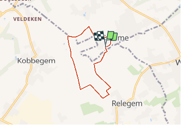
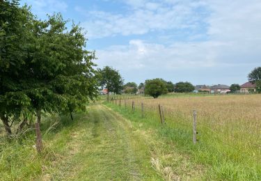
Trail Walking of 5.4 km to be discovered at Flanders, Flemish Brabant, Merchtem. This trail is proposed by corry.vandenbroeke.
Description
Start iets verder dan de parking Sint-gudulakerk - lindedreef (Na huisnummer 100). Prachtige wandeling tussen de velden. Wandeling uitgestippeld door StepAway.be
Positioning
Country:
Belgium
Region :
Flanders
Department/Province :
Flemish Brabant
Municipality :
Merchtem
Location:
Hamme
Start:(Dec)
Start:(UTM)
589519 ; 5640806 (31U) N.
Comments
Trails nearby
![Trail Walking Jette - RB-BXL-03 - Photo](https://media.geolcdn.com/t/375/260/ext.jpg?maxdim=2&url=https%3A%2F%2Fservices.sitytrail.com%2FGeolivesWS%2FDownloadMedia.ashx%3FTrailID%3D247875%26Media%3Da6927d94-8231-444f-b471-9c7fccf44207.jpg)
![Walking Walking](https://static1.geolcdn.com/sitytour/trail-icons/101.png)
RB-BXL-03
Walking
Difficult
(2)
Jette,
Brussels-Capital,
Unknown,
Belgium
![](/images/other/stat-length.png)
25 km | 29 km-effort
6h 36min
![](https://static1.geolcdn.com/siteimages/upload/files/16400158638029165_repeat_loop_refresh_sync_direction_icon.png)
Yes
![Trail Walking City of Brussels - RB-BXL-02 - Photo](https://media.geolcdn.com/t/375/260/ext.jpg?maxdim=2&url=https%3A%2F%2Fservices.sitytrail.com%2FGeolivesWS%2FDownloadMedia.ashx%3FTrailID%3D247873%26Media%3Ddfaf2d4a-e0b3-4c36-97b5-3b14c6762b25.jpg)
![Walking Walking](https://static1.geolcdn.com/sitytour/trail-icons/101.png)
RB-BXL-02
Walking
Medium
(1)
City of Brussels,
Brussels-Capital,
Unknown,
Belgium
![](/images/other/stat-length.png)
21 km | 24 km-effort
5h 32min
![](https://static1.geolcdn.com/siteimages/upload/files/16400158638029165_repeat_loop_refresh_sync_direction_icon.png)
Yes
![Trail Walking City of Brussels - RB-Br-01 Raccourci - Photo](https://media.geolcdn.com/t/375/260/ext.jpg?maxdim=2&url=https%3A%2F%2Fservices.sitytrail.com%2FGeolivesWS%2FDownloadMedia.ashx%3FTrailID%3D247871%26Media%3Dc4587231-2ae7-41fa-9d29-8fa1efb02129.jpg)
![Walking Walking](https://static1.geolcdn.com/sitytour/trail-icons/101.png)
RB-Br-01 Raccourci
Walking
Easy
(3)
City of Brussels,
Brussels-Capital,
Unknown,
Belgium
![](/images/other/stat-length.png)
16 km | 19 km-effort
4h 19min
![](https://static1.geolcdn.com/siteimages/upload/files/16400158638029165_repeat_loop_refresh_sync_direction_icon.png)
Yes
![Trail Walking Meise - Meise 2 - 7,3 Km - Photo](https://media.geolcdn.com/t/375/260/ext.jpg?maxdim=2&url=https%3A%2F%2Fmedia.geolcdn.com%2Ff%2F5b2154f2-ba55-4513-bd2f-9db37eb5ea90.jpg)
![Walking Walking](https://static1.geolcdn.com/sitytour/trail-icons/101.png)
Meise 2 - 7,3 Km
Walking
Easy
(1)
Meise,
Flanders,
Flemish Brabant,
Belgium
![](/images/other/stat-length.png)
7.3 km | 8 km-effort
2h 34min
![](https://static1.geolcdn.com/siteimages/upload/files/16400158638029165_repeat_loop_refresh_sync_direction_icon.png)
Yes
![Trail Walking Wemmel - Wemmel Beverbos 6 km - Photo](https://media.geolcdn.com/t/375/260/ext.jpg?maxdim=2&url=https%3A%2F%2Fmedia.geolcdn.com%2Ff%2F3be3b710-42f6-4600-9f48-b1342818e945.jpg)
![Walking Walking](https://static1.geolcdn.com/sitytour/trail-icons/101.png)
Wemmel Beverbos 6 km
Walking
Medium
(2)
Wemmel,
Flanders,
Flemish Brabant,
Belgium
![](/images/other/stat-length.png)
6.7 km | 7.6 km-effort
1h 32min
![](https://static1.geolcdn.com/siteimages/upload/files/16400158638029165_repeat_loop_refresh_sync_direction_icon.png)
Yes
![Trail Cycle City of Brussels - Atomium à Atlas - Photo](https://media.geolcdn.com/t/375/260/ext.jpg?maxdim=2&url=https%3A%2F%2Fservices.sitytrail.com%2FGeolivesWS%2FDownloadMedia.ashx%3FTrailID%3D190938%26Media%3D20130510152551.jpeg)
![Cycle Cycle](https://static1.geolcdn.com/sitytour/trail-icons/200.png)
Atomium à Atlas
Cycle
Medium
(1)
City of Brussels,
Brussels-Capital,
Unknown,
Belgium
![](/images/other/stat-length.png)
45 km | 52 km-effort
2h 58min
![](https://static1.geolcdn.com/siteimages/upload/files/16400158638029165_repeat_loop_refresh_sync_direction_icon.png)
No
![Trail Walking Berchem-Sainte-Agathe - Sint-Agatha-Berchem - Berchem Cinquantenaire 13.7 km - Photo](https://media.geolcdn.com/t/375/260/ext.jpg?maxdim=2&url=https%3A%2F%2Fmedia.geolcdn.com%2Ff%2F7407fd43-fb12-43d9-bd02-ae43914d5b03.jpg)
![Walking Walking](https://static1.geolcdn.com/sitytour/trail-icons/101.png)
Berchem Cinquantenaire 13.7 km
Walking
Easy
Berchem-Sainte-Agathe - Sint-Agatha-Berchem,
Brussels-Capital,
Unknown,
Belgium
![](/images/other/stat-length.png)
13.8 km | 16.1 km-effort
3h 34min
![](https://static1.geolcdn.com/siteimages/upload/files/16400158638029165_repeat_loop_refresh_sync_direction_icon.png)
No
![Trail Walking Asse - Asse 25 km - Photo](https://media.geolcdn.com/t/375/260/ext.jpg?maxdim=2&url=https%3A%2F%2Fmedia.geolcdn.com%2Ff%2F93373654-1789-4a22-a980-4e4078e012f6.jpg)
![Walking Walking](https://static1.geolcdn.com/sitytour/trail-icons/101.png)
![Trail Walking Merchtem - Brussegem nord 7,3 km - Photo](https://media.geolcdn.com/t/375/260/ext.jpg?maxdim=2&url=https%3A%2F%2Fmedia.geolcdn.com%2Ff%2Fc2a2b302-b3fd-44e8-9488-687c48558849.jpg)
![Walking Walking](https://static1.geolcdn.com/sitytour/trail-icons/101.png)
Brussegem nord 7,3 km
Walking
Easy
Merchtem,
Flanders,
Flemish Brabant,
Belgium
![](/images/other/stat-length.png)
7.5 km | 8.3 km-effort
1h 40min
![](https://static1.geolcdn.com/siteimages/upload/files/16400158638029165_repeat_loop_refresh_sync_direction_icon.png)
Yes