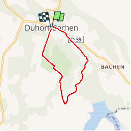
![](/images/other/stat-length.png)
![Trail Walking Duhort-Bachen - vallons du lourden - Photo](https://media.geolcdn.com/t/1900/400/ext.pjpeg?maxdim=2&url=https%3A%2F%2Fstatic1.geolcdn.com%2Fsiteimages%2Fupload%2Ffiles%2F1553511878bg_sport_marche.png)
vallons du lourden
papiou
User
![Length](/images/other/stat-length.png)
Length
5.7 km
![Max alt](https://static1.geolcdn.com/siteimages/upload/files/1508320355ic_sort_altitude_max_24dp.png)
Max alt
150 m
![Uphill gradient](https://static1.geolcdn.com/siteimages/upload/files/1508320355ic_sort_den_pos_24dp.png)
Uphill gradient
86 m
![Km-Effort](/images/other/stat-length.png)
Km-Effort
6.8 km
![Min alt](https://static1.geolcdn.com/siteimages/upload/files/1508320355ic_sort_altitude_min_24dp.png)
Min alt
94 m
![Downhill gradient](https://static1.geolcdn.com/siteimages/upload/files/1508320355ic_sort_den_neg_24dp.png)
Downhill gradient
84 m
![Boucle](https://static1.geolcdn.com/siteimages/upload/files/16400158638029165_repeat_loop_refresh_sync_direction_icon.png)
Boucle
Yes
Creation date :
2016-10-21 00:00:00.0
Updated on :
2016-10-21 00:00:00.0
![Walking](https://static1.geolcdn.com/sitytour/trail-icons/101.png)
1h30
Difficulty : Medium
![Scan this QR Code to open this trail in the SityTrail application](https://capi.geolives.com/qq0zvz2zws4bq2lad0pu/sitytour/trails/648935/qr.png?size=200)
FREE GPS app for hiking
About
Trail Walking of 5.7 km to be discovered at New Aquitaine, Landes, Duhort-Bachen. This trail is proposed by papiou.
Description
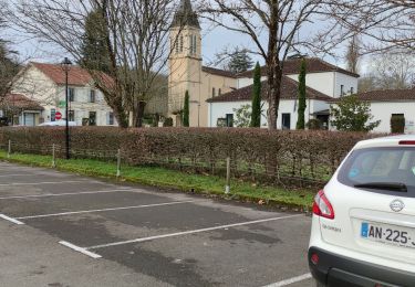
Rdv place village, prendre le long église et suivre balisage, à la sortie du bois prendre balisage boucle moyenne qui vous ramène au point de départ
Positioning
Country:
France
Region :
New Aquitaine
Department/Province :
Landes
Municipality :
Duhort-Bachen
Location:
Unknown
Start:(Dec)
Start:(UTM)
715568 ; 4844760 (30T) N.
Comments
Trails nearby
![Trail Walking Aire-sur-l'Adour - Mon Compostelle treizième étape - Photo](https://media.geolcdn.com/t/375/260/ext.jpg?maxdim=2&url=https%3A%2F%2Fservices.sitytrail.com%2FGeolivesWS%2FDownloadMedia.ashx%3FTrailID%3D685415%26Media%3Df6ccbe4e-a997-4a20-bc2f-eaf1fb575a16.JPG)
![Walking Walking](https://static1.geolcdn.com/sitytour/trail-icons/101.png)
Mon Compostelle treizième étape
Walking
Very difficult
Aire-sur-l'Adour,
New Aquitaine,
Landes,
France
![](/images/other/stat-length.png)
54 km | 66 km-effort
10h 40min
![](https://static1.geolcdn.com/siteimages/upload/files/16400158638029165_repeat_loop_refresh_sync_direction_icon.png)
No
![Trail Walking Aire-sur-l'Adour - 4 aire - Photo](https://media.geolcdn.com/t/375/260/ext.jpg?maxdim=2&url=https%3A%2F%2Fstatic1.geolcdn.com%2Fsiteimages%2Fupload%2Ffiles%2F1553511878bg_sport_marche.png)
![Walking Walking](https://static1.geolcdn.com/sitytour/trail-icons/101.png)
4 aire
Walking
Difficult
Aire-sur-l'Adour,
New Aquitaine,
Landes,
France
![](/images/other/stat-length.png)
28 km | 34 km-effort
8h 11min
![](https://static1.geolcdn.com/siteimages/upload/files/16400158638029165_repeat_loop_refresh_sync_direction_icon.png)
No
![Trail Walking Aire-sur-l'Adour - Camino 1 étape 26 du 20.08.2023 - Photo](https://media.geolcdn.com/t/375/260/ext.jpg?maxdim=2&url=https%3A%2F%2Fstatic1.geolcdn.com%2Fsiteimages%2Fupload%2Ffiles%2F1553511878bg_sport_marche.png)
![Walking Walking](https://static1.geolcdn.com/sitytour/trail-icons/101.png)
Camino 1 étape 26 du 20.08.2023
Walking
Difficult
Aire-sur-l'Adour,
New Aquitaine,
Landes,
France
![](/images/other/stat-length.png)
32 km | 40 km-effort
9h 14min
![](https://static1.geolcdn.com/siteimages/upload/files/16400158638029165_repeat_loop_refresh_sync_direction_icon.png)
No
![Trail Electric bike Aire-sur-l'Adour - 012 Aire sur l'Adour to Larreule - Photo](https://media.geolcdn.com/t/375/260/ext.jpg?maxdim=2&url=https%3A%2F%2Fstatic1.geolcdn.com%2Fsiteimages%2Fupload%2Ffiles%2F1524743154velo.jpg)
![Electric bike Electric bike](https://static1.geolcdn.com/sitytour/trail-icons/205.png)
012 Aire sur l'Adour to Larreule
Electric bike
Very easy
Aire-sur-l'Adour,
New Aquitaine,
Landes,
France
![](/images/other/stat-length.png)
42 km | 52 km-effort
Unknown
![](https://static1.geolcdn.com/siteimages/upload/files/16400158638029165_repeat_loop_refresh_sync_direction_icon.png)
No
![Trail Bicycle tourism Aire-sur-l'Adour - 012 Adour to Larreule - Photo](https://media.geolcdn.com/t/375/260/ext.jpg?maxdim=2&url=https%3A%2F%2Fstatic1.geolcdn.com%2Fsiteimages%2Fupload%2Ffiles%2F1524743154velo.jpg)
![Bicycle tourism Bicycle tourism](https://static1.geolcdn.com/sitytour/trail-icons/204.png)
012 Adour to Larreule
Bicycle tourism
Aire-sur-l'Adour,
New Aquitaine,
Landes,
France
![](/images/other/stat-length.png)
48 km | 57 km-effort
Unknown
![](https://static1.geolcdn.com/siteimages/upload/files/16400158638029165_repeat_loop_refresh_sync_direction_icon.png)
No
![Trail Road bike Eugénie-les-Bains - aires sur Adour - Photo](https://media.geolcdn.com/t/375/260/ext.jpg?maxdim=2&url=https%3A%2F%2Fstatic1.geolcdn.com%2Fsiteimages%2Fupload%2Ffiles%2F1524743154velo.jpg)
![Road bike Road bike](https://static1.geolcdn.com/sitytour/trail-icons/201.png)
aires sur Adour
Road bike
Medium
Eugénie-les-Bains,
New Aquitaine,
Landes,
France
![](/images/other/stat-length.png)
44 km | 49 km-effort
2h 11min
![](https://static1.geolcdn.com/siteimages/upload/files/16400158638029165_repeat_loop_refresh_sync_direction_icon.png)
Yes
![Trail Walking Aire-sur-l'Adour - Compostelle 2015 - Aire-sur-l'Adour -> St-Jean-Pied-de-Port - Photo](https://media.geolcdn.com/t/375/260/ext.jpg?maxdim=2&url=https%3A%2F%2Fstatic1.geolcdn.com%2Fsiteimages%2Fupload%2Ffiles%2F1553511878bg_sport_marche.png)
![Walking Walking](https://static1.geolcdn.com/sitytour/trail-icons/101.png)
Compostelle 2015 - Aire-sur-l'Adour -> St-Jean-Pied-de-Port
Walking
Easy
Aire-sur-l'Adour,
New Aquitaine,
Landes,
France
![](/images/other/stat-length.png)
174 km | 218 km-effort
43h 30min
![](https://static1.geolcdn.com/siteimages/upload/files/16400158638029165_repeat_loop_refresh_sync_direction_icon.png)
No
![Trail Walking Aire-sur-l'Adour - Compostelle 27 - Aire-sur-Adour -> Miramont - Photo](https://media.geolcdn.com/t/375/260/ext.jpg?maxdim=2&url=https%3A%2F%2Fstatic1.geolcdn.com%2Fsiteimages%2Fupload%2Ffiles%2F1553511878bg_sport_marche.png)
![Walking Walking](https://static1.geolcdn.com/sitytour/trail-icons/101.png)
Compostelle 27 - Aire-sur-Adour -> Miramont
Walking
Easy
Aire-sur-l'Adour,
New Aquitaine,
Landes,
France
![](/images/other/stat-length.png)
18.9 km | 22 km-effort
4h 48min
![](https://static1.geolcdn.com/siteimages/upload/files/16400158638029165_repeat_loop_refresh_sync_direction_icon.png)
No
![Trail Walking Aire-sur-l'Adour - StJ-J39-Aire sur l'Adour-Pimbo - Photo](https://media.geolcdn.com/t/375/260/ext.jpg?maxdim=2&url=https%3A%2F%2Fstatic1.geolcdn.com%2Fsiteimages%2Fupload%2Ffiles%2F1553511878bg_sport_marche.png)
![Walking Walking](https://static1.geolcdn.com/sitytour/trail-icons/101.png)
StJ-J39-Aire sur l'Adour-Pimbo
Walking
Very difficult
Aire-sur-l'Adour,
New Aquitaine,
Landes,
France
![](/images/other/stat-length.png)
27 km | 32 km-effort
7h 0min
![](https://static1.geolcdn.com/siteimages/upload/files/16400158638029165_repeat_loop_refresh_sync_direction_icon.png)
No