![](/images/other/stat-length.png)
![Trail Walking Roost-Warendin - Roost Warendint : Escarpelle et Paturelle - Photo](https://media.geolcdn.com/t/1900/400/ext.pjpeg?maxdim=2&url=https%3A%2F%2Fstatic1.geolcdn.com%2Fsiteimages%2Fupload%2Ffiles%2F1553511878bg_sport_marche.png)
Roost Warendint : Escarpelle et Paturelle
dehemjacques
User
![Length](/images/other/stat-length.png)
Length
10.9 km
![Max alt](https://static1.geolcdn.com/siteimages/upload/files/1508320355ic_sort_altitude_max_24dp.png)
Max alt
89 m
![Uphill gradient](https://static1.geolcdn.com/siteimages/upload/files/1508320355ic_sort_den_pos_24dp.png)
Uphill gradient
136 m
![Km-Effort](/images/other/stat-length.png)
Km-Effort
12.7 km
![Min alt](https://static1.geolcdn.com/siteimages/upload/files/1508320355ic_sort_altitude_min_24dp.png)
Min alt
14 m
![Downhill gradient](https://static1.geolcdn.com/siteimages/upload/files/1508320355ic_sort_den_neg_24dp.png)
Downhill gradient
136 m
![Boucle](https://static1.geolcdn.com/siteimages/upload/files/16400158638029165_repeat_loop_refresh_sync_direction_icon.png)
Boucle
Yes
Creation date :
2016-10-14 00:00:00.0
Updated on :
2016-10-14 00:00:00.0
![Walking](https://static1.geolcdn.com/sitytour/trail-icons/101.png)
2h47
Difficulty : Medium
![Scan this QR Code to open this trail in the SityTrail application](https://capi.geolives.com/qq0zvz2zws4bq2lad0pu/sitytour/trails/645502/qr.png?size=200)
FREE GPS app for hiking
About
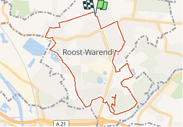
Trail Walking of 10.9 km to be discovered at Hauts-de-France, Nord, Roost-Warendin. This trail is proposed by dehemjacques.
Description
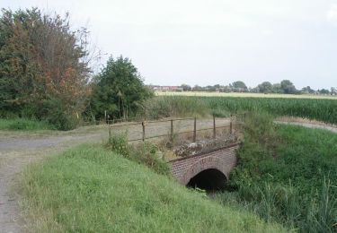
Départ du Château de Bernicourt,
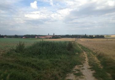
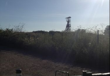
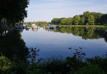
traverser la réserve naturelle des Annelles-Lains- Pont Pinnet puis se diriger vers le terril de l'Escarpelle et retour par le contournement de l'étang de pêche des Paturelles
Positioning
Country:
France
Region :
Hauts-de-France
Department/Province :
Nord
Municipality :
Roost-Warendin
Location:
Unknown
Start:(Dec)
Start:(UTM)
507332 ; 5585566 (31U) N.
Comments
Trails nearby
![Trail Mountain bike Lallaing - lallaing - la fosse delloye - Photo](https://media.geolcdn.com/t/375/260/ext.jpg?maxdim=2&url=https%3A%2F%2Fservices.sitytrail.com%2FGeolivesWS%2FDownloadMedia.ashx%3FTrailID%3D148722%26Media%3D20120821181041.jpg)
![Mountain bike Mountain bike](https://static1.geolcdn.com/sitytour/trail-icons/202.png)
lallaing - la fosse delloye
Mountain bike
Medium
(1)
Lallaing,
Hauts-de-France,
Nord,
France
![](/images/other/stat-length.png)
26 km | 29 km-effort
1h 41min
![](https://static1.geolcdn.com/siteimages/upload/files/16400158638029165_repeat_loop_refresh_sync_direction_icon.png)
No
![Trail Mountain bike Lallaing - 2012-08-17 lallaing 3 cavaliers - Photo](https://media.geolcdn.com/t/375/260/ext.jpg?maxdim=2&url=https%3A%2F%2Fservices.sitytrail.com%2FGeolivesWS%2FDownloadMedia.ashx%3FTrailID%3D147793%26Media%3D20120817182019.jpg)
![Mountain bike Mountain bike](https://static1.geolcdn.com/sitytour/trail-icons/202.png)
2012-08-17 lallaing 3 cavaliers
Mountain bike
Medium
(1)
Lallaing,
Hauts-de-France,
Nord,
France
![](/images/other/stat-length.png)
44 km | 47 km-effort
2h 50min
![](https://static1.geolcdn.com/siteimages/upload/files/16400158638029165_repeat_loop_refresh_sync_direction_icon.png)
No
![Trail Mountain bike Lallaing - lallaing - circuit de l'elpret - Photo](https://media.geolcdn.com/t/375/260/ext.jpg?maxdim=2&url=https%3A%2F%2Fstatic1.geolcdn.com%2Fsiteimages%2Fupload%2Ffiles%2F1524743154velo.jpg)
![Mountain bike Mountain bike](https://static1.geolcdn.com/sitytour/trail-icons/202.png)
lallaing - circuit de l'elpret
Mountain bike
Medium
(1)
Lallaing,
Hauts-de-France,
Nord,
France
![](/images/other/stat-length.png)
40 km | 43 km-effort
2h 56min
![](https://static1.geolcdn.com/siteimages/upload/files/16400158638029165_repeat_loop_refresh_sync_direction_icon.png)
Yes
![Trail Mountain bike Anhiers - lallaing - Mons en peveles - Photo](https://media.geolcdn.com/t/375/260/ext.jpg?maxdim=2&url=https%3A%2F%2Fstatic1.geolcdn.com%2Fsiteimages%2Fupload%2Ffiles%2F1524743154velo.jpg)
![Mountain bike Mountain bike](https://static1.geolcdn.com/sitytour/trail-icons/202.png)
lallaing - Mons en peveles
Mountain bike
Easy
(1)
Anhiers,
Hauts-de-France,
Nord,
France
![](/images/other/stat-length.png)
27 km | 29 km-effort
1h 32min
![](https://static1.geolcdn.com/siteimages/upload/files/16400158638029165_repeat_loop_refresh_sync_direction_icon.png)
No
![Trail Mountain bike Anhiers - rando renard - Photo](https://media.geolcdn.com/t/375/260/ext.jpg?maxdim=2&url=https%3A%2F%2Fstatic1.geolcdn.com%2Fsiteimages%2Fupload%2Ffiles%2F1524743154velo.jpg)
![Mountain bike Mountain bike](https://static1.geolcdn.com/sitytour/trail-icons/202.png)
rando renard
Mountain bike
Very easy
(1)
Anhiers,
Hauts-de-France,
Nord,
France
![](/images/other/stat-length.png)
20 km | 22 km-effort
1h 17min
![](https://static1.geolcdn.com/siteimages/upload/files/16400158638029165_repeat_loop_refresh_sync_direction_icon.png)
No
![Trail Walking Auby - boucle des 3 cavaliers départ Auby - Photo](https://media.geolcdn.com/t/375/260/341a75ed-df9b-4e46-8149-070d6bbef0ed.jpg&format=jpg&maxdim=2)
![Walking Walking](https://static1.geolcdn.com/sitytour/trail-icons/101.png)
boucle des 3 cavaliers départ Auby
Walking
Very difficult
(1)
Auby,
Hauts-de-France,
Nord,
France
![](/images/other/stat-length.png)
23 km | 25 km-effort
6h 6min
![](https://static1.geolcdn.com/siteimages/upload/files/16400158638029165_repeat_loop_refresh_sync_direction_icon.png)
Yes
![Trail Walking Auby - boucle Auby - Port d'eau Courcelles-lès-Lens - Photo](https://media.geolcdn.com/t/375/260/614df3b6-df05-46fc-8e4f-2f6cc2d5878b.jpg&format=jpg&maxdim=2)
![Walking Walking](https://static1.geolcdn.com/sitytour/trail-icons/101.png)
boucle Auby - Port d'eau Courcelles-lès-Lens
Walking
Medium
Auby,
Hauts-de-France,
Nord,
France
![](/images/other/stat-length.png)
10.1 km | 10.8 km-effort
2h 10min
![](https://static1.geolcdn.com/siteimages/upload/files/16400158638029165_repeat_loop_refresh_sync_direction_icon.png)
Yes
![Trail Nordic walking Leforest - ostricourt - Photo](https://media.geolcdn.com/t/375/260/ext.jpg?maxdim=2&url=https%3A%2F%2Fstatic1.geolcdn.com%2Fsiteimages%2Fupload%2Ffiles%2F1545311037marcheuse_200dpi.jpg)
![Nordic walking Nordic walking](https://static1.geolcdn.com/sitytour/trail-icons/102.png)
ostricourt
Nordic walking
Very easy
(1)
Leforest,
Hauts-de-France,
Pas-de-Calais,
France
![](/images/other/stat-length.png)
6.6 km | 7.7 km-effort
1h 26min
![](https://static1.geolcdn.com/siteimages/upload/files/16400158638029165_repeat_loop_refresh_sync_direction_icon.png)
Yes
![Trail Walking Anhiers - Circuit des 2 ponts - Anhiers - Photo](https://media.geolcdn.com/t/375/260/ext.jpg?maxdim=2&url=https%3A%2F%2Fservices.sitytrail.com%2FGeolivesWS%2FDownloadMedia.ashx%3FTrailID%3D111910%26Media%3D8918_6.jpg)
![Walking Walking](https://static1.geolcdn.com/sitytour/trail-icons/101.png)
Circuit des 2 ponts - Anhiers
Walking
Easy
Anhiers,
Hauts-de-France,
Nord,
France
![](/images/other/stat-length.png)
7.1 km | 7.4 km-effort
1h 49min
![](https://static1.geolcdn.com/siteimages/upload/files/16400158638029165_repeat_loop_refresh_sync_direction_icon.png)
Yes
belle découverte de roost Warendin. patrimoine bâti et industriel. le château est magnifique et son ecomusee vaut une visite (s'adresser en mairie)