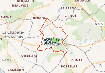
![](/images/other/stat-length.png)
![Trail Walking Sainte-Reine-de-Bretagne - mou - Photo](https://media.geolcdn.com/t/1900/400/ext.pjpeg?maxdim=2&url=https%3A%2F%2Fstatic1.geolcdn.com%2Fsiteimages%2Fupload%2Ffiles%2F1553511878bg_sport_marche.png)
mou
neoroll44
User
![Length](/images/other/stat-length.png)
![Max alt](https://static1.geolcdn.com/siteimages/upload/files/1508320355ic_sort_altitude_max_24dp.png)
![Uphill gradient](https://static1.geolcdn.com/siteimages/upload/files/1508320355ic_sort_den_pos_24dp.png)
![Km-Effort](/images/other/stat-length.png)
![Min alt](https://static1.geolcdn.com/siteimages/upload/files/1508320355ic_sort_altitude_min_24dp.png)
![Downhill gradient](https://static1.geolcdn.com/siteimages/upload/files/1508320355ic_sort_den_neg_24dp.png)
![Boucle](https://static1.geolcdn.com/siteimages/upload/files/16400158638029165_repeat_loop_refresh_sync_direction_icon.png)
![Walking](https://static1.geolcdn.com/sitytour/trail-icons/101.png)
2h48
Difficulty : Medium
![Scan this QR Code to open this trail in the SityTrail application](https://capi.geolives.com/qq0zvz2zws4bq2lad0pu/sitytour/trails/640951/qr.png?size=200)
FREE GPS app for hiking
About
Trail Walking of 11.6 km to be discovered at Pays de la Loire, Loire-Atlantique, Sainte-Reine-de-Bretagne. This trail is proposed by neoroll44.
Description
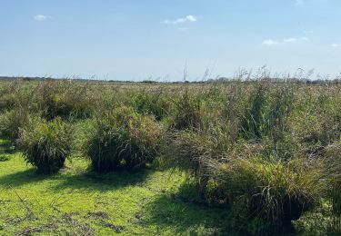
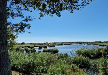
Départ au plan d'eau du Trou à Tenaud. A partir du panneau de départ, laissez le plan d’eau sur la gauche et dirigez-vous vers la petite passerelle où vous tournerez à droite à sa sortie. Prenez à gauche et encore à gauche 50m plus loin, rue Aristide Briand. Empruntez le 1er chemin à droite puis à gauche à l’intersection. Franchissez la passerelle et continuez le marais vers la droite. A la route tournez à droite, puis la 1ère à gauche et, 100m plus loin prenez à droite jusqu’à l’entrée de Sainte-Reine-de-Bretagne.
1) Après le pont, tournez à gauche et traversez tout droit le marais. Prenez le 1er chemin à gauche puis à droite avant le Bas-Bergon et continuez jusqu’au Haut-Bergon. Traversez prudemment la RD 4.
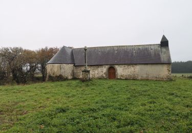
2) Tournez à droite à l’intersection et plus loin, bifurquez à droite. Dépassez la croix de l’étang de Crévy.
3) Avant l’Organais, prendre d’abord à droite, puis au stop à gauche et ensuite à droite, rue des Lauriers. Continuez rue des Cormiers et tournez à droite. 200m après, prenez à gauche et, au bout du chemin, tournez à droite.
4) Continuez tout droit et traversez prudemment la RD 33. Au Moulin Neuf, tournez à gauche. Laissez la zone des Moulins sur votre droite et continuez tout droit. Au bout du chemin, tournez à droite.
5) Avant la route de Crossac, tournez à droite et prenez le 1er chemin à gauche. Traversez prudemment la D4 et dirigez-vous vers la rue du Chaume. Passez près du four à pain et tournez à droite rue des Nénuphars.
6) Tournez à droite à la dernière maison et 100m tournez à gauche 100 m plus loin pour entrer dans le sous-bois. A la sortie du sous-bois prenez à droite pour rejoindre le parc.
Positioning
Comments
Trails nearby
![Trail Walking La Chapelle-des-Marais - La Chapelle des Marais - Promenade du Héron - Photo](https://media.geolcdn.com/t/375/260/ead6c4de-9096-43f4-a52b-fac7b063903f.jpg&format=jpg&maxdim=2)
![Walking Walking](https://static1.geolcdn.com/sitytour/trail-icons/101.png)
Walking
![](/images/other/stat-length.png)
![](https://static1.geolcdn.com/siteimages/upload/files/16400158638029165_repeat_loop_refresh_sync_direction_icon.png)
![Trail Walking Crossac - 2013-04-18T15:24:07Z - Photo](https://media.geolcdn.com/t/375/260/31db2e32-116b-4ea2-8051-f37802eeff1d.jpeg&format=jpg&maxdim=2)
![Walking Walking](https://static1.geolcdn.com/sitytour/trail-icons/101.png)
Walking
![](/images/other/stat-length.png)
![](https://static1.geolcdn.com/siteimages/upload/files/16400158638029165_repeat_loop_refresh_sync_direction_icon.png)
![Trail Walking La Chapelle-des-Marais - Ranretz La Chapelle des Marais 12.00 - Photo](https://media.geolcdn.com/t/375/260/ext.jpg?maxdim=2&url=https%3A%2F%2Fstatic1.geolcdn.com%2Fsiteimages%2Fupload%2Ffiles%2F1553511878bg_sport_marche.png)
![Walking Walking](https://static1.geolcdn.com/sitytour/trail-icons/101.png)
Walking
![](/images/other/stat-length.png)
![](https://static1.geolcdn.com/siteimages/upload/files/16400158638029165_repeat_loop_refresh_sync_direction_icon.png)
![Trail Walking La Chapelle-des-Marais - La Chapelle des marais 2011-06-25 - Photo](https://media.geolcdn.com/t/375/260/ext.jpg?maxdim=2&url=https%3A%2F%2Fstatic1.geolcdn.com%2Fsiteimages%2Fupload%2Ffiles%2F1553511878bg_sport_marche.png)
![Walking Walking](https://static1.geolcdn.com/sitytour/trail-icons/101.png)
Walking
![](/images/other/stat-length.png)
![](https://static1.geolcdn.com/siteimages/upload/files/16400158638029165_repeat_loop_refresh_sync_direction_icon.png)
![Trail Walking La Chapelle-des-Marais - Ballade Le Héron à la Chapelle des Marais - Photo](https://media.geolcdn.com/t/375/260/b9b232ed-d63d-493f-82ef-d2c088c4c199.jpg&format=jpg&maxdim=2)
![Walking Walking](https://static1.geolcdn.com/sitytour/trail-icons/101.png)
Walking
![](/images/other/stat-length.png)
![](https://static1.geolcdn.com/siteimages/upload/files/16400158638029165_repeat_loop_refresh_sync_direction_icon.png)
![Trail Walking La Chapelle-des-Marais - Chapelle des Marais - Balade du Héron - Photo](https://media.geolcdn.com/t/375/260/2beccef5-85f9-4f60-a115-5ee3ee7ce597.jpg&format=jpg&maxdim=2)
![Walking Walking](https://static1.geolcdn.com/sitytour/trail-icons/101.png)
Walking
![](/images/other/stat-length.png)
![](https://static1.geolcdn.com/siteimages/upload/files/16400158638029165_repeat_loop_refresh_sync_direction_icon.png)
![Trail Walking Missillac - 201- Missillac - Photo](https://media.geolcdn.com/t/375/260/f21f79f1-3036-45af-975b-a506ec96e3c9.jpg&format=jpg&maxdim=2)
![Walking Walking](https://static1.geolcdn.com/sitytour/trail-icons/101.png)
Walking
![](/images/other/stat-length.png)
![](https://static1.geolcdn.com/siteimages/upload/files/16400158638029165_repeat_loop_refresh_sync_direction_icon.png)
![Trail Walking Sainte-Reine-de-Bretagne - NDCBP2 - Photo](https://media.geolcdn.com/t/375/260/ext.jpg?maxdim=2&url=https%3A%2F%2Fstatic1.geolcdn.com%2Fsiteimages%2Fupload%2Ffiles%2F1553511878bg_sport_marche.png)
![Walking Walking](https://static1.geolcdn.com/sitytour/trail-icons/101.png)
Walking
![](/images/other/stat-length.png)
![](https://static1.geolcdn.com/siteimages/upload/files/16400158638029165_repeat_loop_refresh_sync_direction_icon.png)
![Trail Mountain bike Crossac - Crossac 2019 - Photo](https://media.geolcdn.com/t/375/260/ext.jpg?maxdim=2&url=https%3A%2F%2Fstatic1.geolcdn.com%2Fsiteimages%2Fupload%2Ffiles%2F1524743154velo.jpg)
![Mountain bike Mountain bike](https://static1.geolcdn.com/sitytour/trail-icons/202.png)
Mountain bike
![](/images/other/stat-length.png)
![](https://static1.geolcdn.com/siteimages/upload/files/16400158638029165_repeat_loop_refresh_sync_direction_icon.png)