![](/images/other/stat-length.png)
![Trail Walking Saint-Denis - Roche écrite à dos d'âne - Photo](https://media.geolcdn.com/t/1900/400/ext.pjpeg?maxdim=2&url=https%3A%2F%2Fstatic1.geolcdn.com%2Fsiteimages%2Fupload%2Ffiles%2F1553511878bg_sport_marche.png)
Roche écrite à dos d'âne
Fdum
User
![Length](/images/other/stat-length.png)
Length
11.3 km
![Max alt](https://static1.geolcdn.com/siteimages/upload/files/1508320355ic_sort_altitude_max_24dp.png)
Max alt
2271 m
![Uphill gradient](https://static1.geolcdn.com/siteimages/upload/files/1508320355ic_sort_den_pos_24dp.png)
Uphill gradient
138 m
![Km-Effort](/images/other/stat-length.png)
Km-Effort
16.8 km
![Min alt](https://static1.geolcdn.com/siteimages/upload/files/1508320355ic_sort_altitude_min_24dp.png)
Min alt
1151 m
![Downhill gradient](https://static1.geolcdn.com/siteimages/upload/files/1508320355ic_sort_den_neg_24dp.png)
Downhill gradient
1243 m
![Boucle](https://static1.geolcdn.com/siteimages/upload/files/16400158638029165_repeat_loop_refresh_sync_direction_icon.png)
Boucle
No
Creation date :
2016-10-01 00:00:00.0
Updated on :
2016-10-01 00:00:00.0
![Walking](https://static1.geolcdn.com/sitytour/trail-icons/101.png)
5h20
Difficulty : Medium
![Scan this QR Code to open this trail in the SityTrail application](https://capi.geolives.com/qq0zvz2zws4bq2lad0pu/sitytour/trails/638949/qr.png?size=200)
FREE GPS app for hiking
About
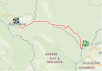
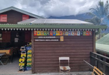
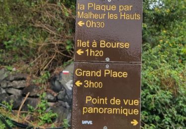
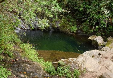
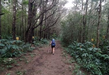
Trail Walking of 11.3 km to be discovered at Réunion, Unknown, Saint-Denis. This trail is proposed by Fdum.
Description
Un peu long sur une seule journée. Privilégier un départ de dos d'âne, avec une nuit au gite des chicots pour monter le lendemain à la roche écrite et descendre par le camp mamode. Il faut un chauffeur !!!
Positioning
Country:
France
Region :
Réunion
Department/Province :
Unknown
Municipality :
Saint-Denis
Location:
Unknown
Start:(Dec)
Start:(UTM)
340061 ; 7675435 (40K) S.
Comments
Trails nearby
![Trail Walking Salazie - Piton d'Anchain - Photo](https://media.geolcdn.com/t/375/260/e4fe93b2-c12b-4594-ba67-cfbaedd38e68.jpg&format=jpg&maxdim=2)
![Walking Walking](https://static1.geolcdn.com/sitytour/trail-icons/101.png)
Piton d'Anchain
Walking
Difficult
Salazie,
Réunion,
Unknown,
France
![](/images/other/stat-length.png)
9.1 km | 19.3 km-effort
2h 48min
![](https://static1.geolcdn.com/siteimages/upload/files/16400158638029165_repeat_loop_refresh_sync_direction_icon.png)
Yes
![Trail sport La Possession - (J4)-Aurère - Mafate les Hauts (fait) - Photo](https://media.geolcdn.com/t/375/260/0d09f72b-41c2-4c29-9aac-6a60b6d1d150.jpg&format=jpg&maxdim=2)
(J4)-Aurère - Mafate les Hauts (fait)
sport
Very easy
La Possession,
Réunion,
Unknown,
France
![](/images/other/stat-length.png)
8.4 km | 16.2 km-effort
Unknown
![](https://static1.geolcdn.com/siteimages/upload/files/16400158638029165_repeat_loop_refresh_sync_direction_icon.png)
No
![Trail sport Saint-Denis - (J2)-Gîte de la Roche Écrite - Dos d’Ane (fait) - Photo](https://media.geolcdn.com/t/375/260/6e842589-3635-43a7-a1bc-65c85b024c08.jpg&format=jpg&maxdim=2)
(J2)-Gîte de la Roche Écrite - Dos d’Ane (fait)
sport
Very easy
Saint-Denis,
Réunion,
Unknown,
France
![](/images/other/stat-length.png)
18.4 km | 29 km-effort
Unknown
![](https://static1.geolcdn.com/siteimages/upload/files/16400158638029165_repeat_loop_refresh_sync_direction_icon.png)
No
![Trail Walking La Possession - jour 2 la Réunion - Photo](https://media.geolcdn.com/t/375/260/175ad4d1-b40a-4791-99a6-341427c8526e.jpg&format=jpg&maxdim=2)
![Walking Walking](https://static1.geolcdn.com/sitytour/trail-icons/101.png)
jour 2 la Réunion
Walking
Medium
La Possession,
Réunion,
Unknown,
France
![](/images/other/stat-length.png)
7.4 km | 13.3 km-effort
7h 7min
![](https://static1.geolcdn.com/siteimages/upload/files/16400158638029165_repeat_loop_refresh_sync_direction_icon.png)
No
![Trail Walking La Possession - Réunion jour 1 - Photo](https://media.geolcdn.com/t/375/260/5c32b1fe-fbf5-4487-8b11-e44026299616.jpg&format=jpg&maxdim=2)
![Walking Walking](https://static1.geolcdn.com/sitytour/trail-icons/101.png)
Réunion jour 1
Walking
Medium
La Possession,
Réunion,
Unknown,
France
![](/images/other/stat-length.png)
7.6 km | 12.6 km-effort
5h 8min
![](https://static1.geolcdn.com/siteimages/upload/files/16400158638029165_repeat_loop_refresh_sync_direction_icon.png)
No
![Trail Trail Salazie - Sentier scoot/ la redoute - Photo](https://media.geolcdn.com/t/375/260/418750c5-718d-4a89-af19-8cd4370c4fad.jpg&format=jpg&maxdim=2)
![Trail Trail](https://static1.geolcdn.com/sitytour/trail-icons/104.png)
Sentier scoot/ la redoute
Trail
Difficult
Salazie,
Réunion,
Unknown,
France
![](/images/other/stat-length.png)
41 km | 74 km-effort
9h 48min
![](https://static1.geolcdn.com/siteimages/upload/files/16400158638029165_repeat_loop_refresh_sync_direction_icon.png)
No
![Trail Walking Salazie - Le km vertical - Photo](https://media.geolcdn.com/t/375/260/125243b2-d794-403c-8ac0-5a23e190b80e.jpg&format=jpg&maxdim=2)
![Walking Walking](https://static1.geolcdn.com/sitytour/trail-icons/101.png)
Le km vertical
Walking
Difficult
Salazie,
Réunion,
Unknown,
France
![](/images/other/stat-length.png)
5.1 km | 16.5 km-effort
2h 56min
![](https://static1.geolcdn.com/siteimages/upload/files/16400158638029165_repeat_loop_refresh_sync_direction_icon.png)
No
![Trail Walking La Possession - Bord Martin - Aurere - par le sentier Scout à l'aller et retour par le sentier Augustave - Photo](https://media.geolcdn.com/t/375/260/a265471e-e71a-4cd3-9405-e3dfdbdedc42.jpg&format=jpg&maxdim=2)
![Walking Walking](https://static1.geolcdn.com/sitytour/trail-icons/101.png)
Bord Martin - Aurere - par le sentier Scout à l'aller et retour par le sentie...
Walking
Difficult
La Possession,
Réunion,
Unknown,
France
![](/images/other/stat-length.png)
16.6 km | 34 km-effort
5h 42min
![](https://static1.geolcdn.com/siteimages/upload/files/16400158638029165_repeat_loop_refresh_sync_direction_icon.png)
Yes
![Trail Walking Salazie - Tour du Piton des Neiges par le petit GRR1 / J1 - Photo](https://media.geolcdn.com/t/375/260/3b1ec1b6-507e-4298-8e46-0fafbef6f638.jpg&format=jpg&maxdim=2)
![Walking Walking](https://static1.geolcdn.com/sitytour/trail-icons/101.png)
Tour du Piton des Neiges par le petit GRR1 / J1
Walking
Difficult
Salazie,
Réunion,
Unknown,
France
![](/images/other/stat-length.png)
15.3 km | 32 km-effort
5h 11min
![](https://static1.geolcdn.com/siteimages/upload/files/16400158638029165_repeat_loop_refresh_sync_direction_icon.png)
No