Trail Mountain bike Mittlach - Mittlach - Le Schweisel - Col d'Hahnenbrunnen - Station du Schnepfenried - Photo

Mittlach - Le Schweisel - Col d'Hahnenbrunnen - Station du Schnepfenried

 sit68000
sit68000

User

© OpenStreetMap contributors
Length
Length
23 km
Max alt
Max alt
1269 m
Uphill gradient
Uphill gradient
801 m
Km-Effort
Km-Effort  
34 km
Min alt
Min alt
637 m
Downhill gradient
Downhill gradient
802 m
Boucle
Boucle
Yes
Creation date :
2016-09-25 00:00:00.0
Updated on :
2016-09-25 00:00:00.0

(0 Reviews)

Mountain bike
Mountain bike
3h30
Difficulty : Difficult

Scan this QR Code to open this trail in the SityTrail application

FREE GPS app for hiking

Logo SityTrail SityTrail

IGN / Geographical institutes

Download SityTrail from the App Store Download SityTrail from Google Play

Logo SityTrail SityTrail World

The world is yours!

Download SityTrail from the App Store Download SityTrail from Google Play Download SityTrail on Huawei AppGallery

About

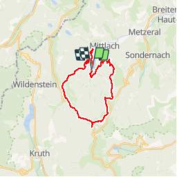
Trail Mountain bike of 23 km to be discovered at Grand Est, Haut-Rhin, Mittlach. This trail is proposed by sit68000.

Description

Après une bonne montée de 7km, arrivée sur les crêtes. Jolie parcours avec des points de vue à 360°.
Repas à la ferme-auberge Hahnenbrunnen.
Ensuite retour par le bois de Munster en passant près de la ferme-auberge Salzbach jusqu'à la ferme-auberge Uff Rain. Puis petite remontée vers la station du Schnepfenried et descente finale en passant par le camping de Mittlach.
Durée 3h30 avec repas et pauses. Sinon 2h20 si aucune pause.

Elevation profile

Photos

Positioning

Country:
France
Region :
Grand Est
Department/Province :
Haut-Rhin
Municipality :
Mittlach
Location:
Unknown
Start:(UTM)
352196 ; 5316801 (32T) N.

Trails nearby

Trail Walking La Bresse - 2023-04-16 Marche Abri Lac de Blanchemer vers Lac de Lispach - Photo
Walking
GUIDE
holtzv

Walking

Very difficult
(1)
La Bresse, Grand Est, Vosges, France
23 km | 36 km-effort
8h 4min
No
Trail Walking Wildenstein - 2022-02-20 Marche Kruth Grand Ventron - Photo
Walking
GUIDE
holtzv

Walking

Very difficult
(1)
Wildenstein, Grand Est, Haut-Rhin, France
16.8 km | 27 km-effort
4h 52min
Yes
Trail Walking Wildenstein - Trek alsacien (boucle de Wildenstein) - Photo
Walking
Godasses et Grosses Pattes

Walking

Difficult
(1)
Wildenstein, Grand Est, Haut-Rhin, France
15.4 km | 24 km-effort
5h 20min
Yes
Trail Walking La Bresse - Kastelberg des pierres, des lacs, des panoramas magnifiques  - Photo
Walking
Alfredy

Walking

Difficult
(1)
La Bresse, Grand Est, Vosges, France
15.1 km | 26 km-effort
6h 11min
Yes
Trail Walking La Bresse - Rainkopf - Mittlach - Hohneck - Photo
Walking
tracegps

Walking

Difficult
(1)
La Bresse, Grand Est, Vosges, France
22 km | 41 km-effort
8h 0min
Yes
Trail Mountain bike Metzeral - Tour du Gaschney par le Sattel - Photo
Mountain bike
tfg

Mountain bike

Difficult
(1)
Metzeral, Grand Est, Haut-Rhin, France
25 km | 37 km-effort
2h 32min
Yes
Trail Mountain bike Metzeral - Sentier des Névés - Photo
Mountain bike
tracegps

Mountain bike

Very difficult
(1)
Metzeral, Grand Est, Haut-Rhin, France
33 km | 52 km-effort
6h 0min
Yes
Trail Walking Mittlach - 2023-09-24 Marche Mittlach 5 Lacs - Photo
Walking
GUIDE
holtzv

Walking

Medium
Mittlach, Grand Est, Haut-Rhin, France
25 km | 41 km-effort
9h 19min
Yes
Trail Walking Sondernach - 2023-05-19 WE Marche Bivouac Massif du Hohneck - Photo
Walking
GUIDE
holtzv

Walking

Medium
Sondernach, Grand Est, Haut-Rhin, France
46 km | 73 km-effort
16h 41min
Yes


Close
My subscriptions