![](/images/other/stat-length.png)
![Trail Walking Evolène - CHX ZRMT Étape 6 d'Arolla à La sage - Photo](https://media.geolcdn.com/t/1900/400/ext.pjpeg?maxdim=2&url=https%3A%2F%2Fservices.sitytrail.com%2FGeolivesWS%2FDownloadMedia.ashx%3FTrailID%3D635934%26Media%3Dfix__20160918145302.jpg)
CHX ZRMT Étape 6 d'Arolla à La sage
jeff2
User
![Length](/images/other/stat-length.png)
Length
17.3 km
![Max alt](https://static1.geolcdn.com/siteimages/upload/files/1508320355ic_sort_altitude_max_24dp.png)
Max alt
2192 m
![Uphill gradient](https://static1.geolcdn.com/siteimages/upload/files/1508320355ic_sort_den_pos_24dp.png)
Uphill gradient
696 m
![Km-Effort](/images/other/stat-length.png)
Km-Effort
28 km
![Min alt](https://static1.geolcdn.com/siteimages/upload/files/1508320355ic_sort_altitude_min_24dp.png)
Min alt
1442 m
![Downhill gradient](https://static1.geolcdn.com/siteimages/upload/files/1508320355ic_sort_den_neg_24dp.png)
Downhill gradient
1095 m
![Boucle](https://static1.geolcdn.com/siteimages/upload/files/16400158638029165_repeat_loop_refresh_sync_direction_icon.png)
Boucle
No
Creation date :
2016-09-25 00:00:00.0
Updated on :
2016-09-25 00:00:00.0
![Walking](https://static1.geolcdn.com/sitytour/trail-icons/101.png)
5h34
Difficulty : Easy
![Scan this QR Code to open this trail in the SityTrail application](https://capi.geolives.com/qq0zvz2zws4bq2lad0pu/sitytour/trails/635934/qr.png?size=200)
FREE GPS app for hiking
About
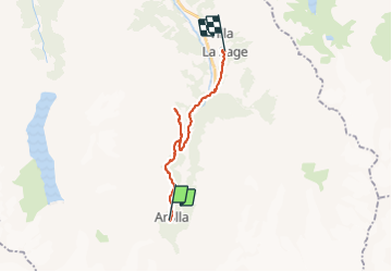
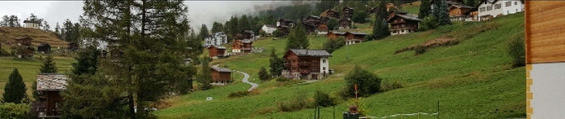
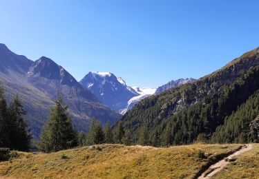
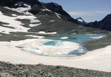
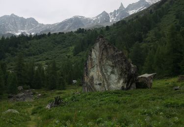
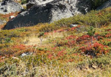
Trail Walking of 17.3 km to be discovered at Valais/Wallis, Hérens, Evolène. This trail is proposed by jeff2.
Description
Tellement fastoche que je me suis perdu !
Positioning
Country:
Switzerland
Region :
Valais/Wallis
Department/Province :
Hérens
Municipality :
Evolène
Location:
Unknown
Start:(Dec)
Start:(UTM)
382328 ; 5097904 (32T) N.
Comments
Trails nearby
![Trail Walking Evolène - Arolla, Cabane des Aiguilles Rouges - Photo](https://media.geolcdn.com/t/375/260/ext.jpg?maxdim=2&url=https%3A%2F%2Fstatic1.geolcdn.com%2Fsiteimages%2Fupload%2Ffiles%2F1553511878bg_sport_marche.png)
![Walking Walking](https://static1.geolcdn.com/sitytour/trail-icons/101.png)
Arolla, Cabane des Aiguilles Rouges
Walking
Very easy
(1)
Evolène,
Valais/Wallis,
Hérens,
Switzerland
![](/images/other/stat-length.png)
11.8 km | 22 km-effort
6h 30min
![](https://static1.geolcdn.com/siteimages/upload/files/16400158638029165_repeat_loop_refresh_sync_direction_icon.png)
Yes
![Trail Walking Evolène - La Haute Route : J5 - Photo](https://media.geolcdn.com/t/375/260/23995d09-2bb0-4904-9a8c-4927f08408c0.jpg&format=jpg&maxdim=2)
![Walking Walking](https://static1.geolcdn.com/sitytour/trail-icons/101.png)
La Haute Route : J5
Walking
Medium
Evolène,
Valais/Wallis,
Hérens,
Switzerland
![](/images/other/stat-length.png)
11.8 km | 19.4 km-effort
3h 18min
![](https://static1.geolcdn.com/siteimages/upload/files/16400158638029165_repeat_loop_refresh_sync_direction_icon.png)
No
![Trail Winter sports Evolène - Verbier/Zermat (Cabane Bertol-Zermatt) - Photo](https://media.geolcdn.com/t/375/260/ext.jpg?maxdim=2&url=https%3A%2F%2Fstatic1.geolcdn.com%2Fsiteimages%2Fupload%2Ffiles%2F1524743153ski.jpg)
![Winter sports Winter sports](https://static1.geolcdn.com/sitytour/trail-icons/500.png)
Verbier/Zermat (Cabane Bertol-Zermatt)
Winter sports
Very easy
Evolène,
Valais/Wallis,
Hérens,
Switzerland
![](/images/other/stat-length.png)
22 km | 42 km-effort
4h 0min
![](https://static1.geolcdn.com/siteimages/upload/files/16400158638029165_repeat_loop_refresh_sync_direction_icon.png)
No
![Trail Winter sports Hérémence - Verbier/Zermat (Cabane des Dix-Cabane des Vignettes) - Photo](https://media.geolcdn.com/t/375/260/ext.jpg?maxdim=2&url=https%3A%2F%2Fstatic1.geolcdn.com%2Fsiteimages%2Fupload%2Ffiles%2F1524743153ski.jpg)
![Winter sports Winter sports](https://static1.geolcdn.com/sitytour/trail-icons/500.png)
Verbier/Zermat (Cabane des Dix-Cabane des Vignettes)
Winter sports
Very easy
Hérémence,
Valais/Wallis,
Hérens,
Switzerland
![](/images/other/stat-length.png)
10.4 km | 26 km-effort
4h 0min
![](https://static1.geolcdn.com/siteimages/upload/files/16400158638029165_repeat_loop_refresh_sync_direction_icon.png)
No
![Trail Other activity Evolène - col du Collon Tour du Cervin - Photo](https://media.geolcdn.com/t/375/260/ext.jpg?maxdim=2&url=https%3A%2F%2Fservices.sitytrail.com%2FGeolivesWS%2FDownloadMedia.ashx%3FTrailID%3D339558%26Media%3D20140824132711.jpg)
![Other activity Other activity](https://static1.geolcdn.com/sitytour/trail-icons/900.png)
col du Collon Tour du Cervin
Other activity
Very easy
Evolène,
Valais/Wallis,
Hérens,
Switzerland
![](/images/other/stat-length.png)
8.3 km | 18.1 km-effort
4h 39min
![](https://static1.geolcdn.com/siteimages/upload/files/16400158638029165_repeat_loop_refresh_sync_direction_icon.png)
No
![Trail Walking Evolène - vs_hike674c - Photo](https://media.geolcdn.com/t/375/260/ext.jpg?maxdim=2&url=https%3A%2F%2Fstatic1.geolcdn.com%2Fsiteimages%2Fupload%2Ffiles%2F1553511878bg_sport_marche.png)
![Walking Walking](https://static1.geolcdn.com/sitytour/trail-icons/101.png)
vs_hike674c
Walking
Very easy
Evolène,
Valais/Wallis,
Hérens,
Switzerland
![](/images/other/stat-length.png)
7.5 km | 10.2 km-effort
1h 53min
![](https://static1.geolcdn.com/siteimages/upload/files/16400158638029165_repeat_loop_refresh_sync_direction_icon.png)
No
![Trail Walking Evolène - st_riedmatten - Photo](https://media.geolcdn.com/t/375/260/ext.jpg?maxdim=2&url=https%3A%2F%2Fstatic1.geolcdn.com%2Fsiteimages%2Fupload%2Ffiles%2F1553511878bg_sport_marche.png)
![Walking Walking](https://static1.geolcdn.com/sitytour/trail-icons/101.png)
st_riedmatten
Walking
Very easy
Evolène,
Valais/Wallis,
Hérens,
Switzerland
![](/images/other/stat-length.png)
16.7 km | 31 km-effort
5h 33min
![](https://static1.geolcdn.com/siteimages/upload/files/16400158638029165_repeat_loop_refresh_sync_direction_icon.png)
No
![Trail Nordic walking Evolène - arola - Photo](https://media.geolcdn.com/t/375/260/a4677de7-93dc-428c-9459-0fae1af68501.jpg&format=jpg&maxdim=2)
![Nordic walking Nordic walking](https://static1.geolcdn.com/sitytour/trail-icons/102.png)
arola
Nordic walking
Very easy
Evolène,
Valais/Wallis,
Hérens,
Switzerland
![](/images/other/stat-length.png)
10.2 km | 14.8 km-effort
2h 43min
![](https://static1.geolcdn.com/siteimages/upload/files/16400158638029165_repeat_loop_refresh_sync_direction_icon.png)
No
![Trail Nordic walking Evolène - descente de la cabane du tsa - Photo](https://media.geolcdn.com/t/375/260/af0bb752-fbe4-4567-8751-6e316549d84b.jpg&format=jpg&maxdim=2)
![Nordic walking Nordic walking](https://static1.geolcdn.com/sitytour/trail-icons/102.png)
descente de la cabane du tsa
Nordic walking
Very easy
Evolène,
Valais/Wallis,
Hérens,
Switzerland
![](/images/other/stat-length.png)
3.2 km | 5.8 km-effort
1h 14min
![](https://static1.geolcdn.com/siteimages/upload/files/16400158638029165_repeat_loop_refresh_sync_direction_icon.png)
No