St Ulphace 18 SityTrail > Trails > Outdoor > France > Pays de la Loire > Sarthe > Saint-Ulphace SityTrail > Trails > Outdoor > France > Pays de la Loire > Sarthe > Saint-Ulphace St Ulphace 18 togolo28 User 3D © OpenStreetMap contributors Length 18.1 km Max alt 260 m Uphill gradient 333 m Km-Effort 23 km Min alt 153 m Downhill gradient 333 m Boucle Yes Creation date : 2017-09-11 00:00:00.0 Updated on : 2017-09-11 00:00:00.0 (0 Reviews) Walking 4h49 Difficulty : Medium FREE GPS app for hiking SityTrail IGN / Geographical institutes SityTrail World The world is yours! About Trail Walking of 18.1 km to be discovered at Pays de la Loire, Sarthe, Saint-Ulphace. This trail is proposed by togolo28. Legends | More details (PDF) Elevation profile Legends > 15% 15% - 10% 10% - 5% flat 5% - 10% 10% - 15% 15% - 30% > 30% Positioning Country: France Region : Pays de la Loire Department/Province : Sarthe Municipality : Saint-Ulphace Location: Unknown Start:(Dec) 48.15911 / 0.816388 Start:(UTM) 337618 ; 5336291 (31U) N. Comments Please log in to post a review or rate the element Trails nearby tracegps Saint Ulphace - Au fil des moulins... Walking Medium Saint-Ulphace, Pays de la Loire, Sarthe, France 
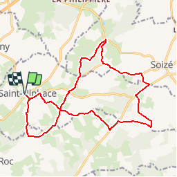
17.4 km | 21 km-effort 4h 0min Yes togolo28 11781140-Authon du Perche 12.82 Walking Easy Authon-du-Perche, Centre-Loire Valley, Eure-et-Loir, France 12.1 km | 15 km-effort Unknown Yes Gaucho essai Car Very easy Authon-du-Perche, Centre-Loire Valley, Eure-et-Loir, France 8.7 km | 10 km-effort 4min No