Trail Mountain bike Romeyer - Ravin de Charose - Photo
 Asgarel
Asgarel

User

© OpenStreetMap contributors
Length
Length
19.4 km
Max alt
Max alt
1372 m
Uphill gradient
Uphill gradient
899 m
Km-Effort
Km-Effort  
31 km
Min alt
Min alt
497 m
Downhill gradient
Downhill gradient
899 m
Boucle
Boucle
Yes
Creation date :
2016-09-24 00:00:00.0
Updated on :
2016-09-24 00:00:00.0

(1 Reviews)

Mountain bike
Mountain bike
2h02
Difficulty : Medium

Scan this QR Code to open this trail in the SityTrail application

FREE GPS app for hiking

Logo SityTrail SityTrail

IGN / Geographical institutes

Download SityTrail from the App Store Download SityTrail from Google Play

Logo SityTrail SityTrail World

The world is yours!

Download SityTrail from the App Store Download SityTrail from Google Play Download SityTrail on Huawei AppGallery

About

Trail Mountain bike of 19.4 km to be discovered at Auvergne-Rhône-Alpes, Drôme, Romeyer. This trail is proposed by Asgarel.

Description

Petit aperçu rapide des Balcons. Jolie montée par le GR jusqu'au col de Vire sac, descente du ravin de Charose parfois un peu raide dans la pierraille. Permet d'éviter les Bichons qui sont interdits à la descente.

Elevation profile

Positioning

Country:
France
Region :
Auvergne-Rhône-Alpes
Department/Province :
Drôme
Municipality :
Romeyer
Location:
Unknown
Start:(UTM)
690552 ; 4961211 (31T) N.

Comments

Please log in to post a review or rate the element


Trails nearby

Trail Mountain bike Chamaloc - Chamaloc - Hauteurs de Die - Photo
Mountain bike
tracegps

Mountain bike

Difficult
(1)
Chamaloc, Auvergne-Rhône-Alpes, Drôme, France
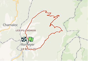
36 km | 50 km-effort
3h 0min
Yes
Trail Walking Romeyer - La rive du rocher des heures - Photo
Walking
GUIDE
nadd73

Walking

Difficult
Romeyer, Auvergne-Rhône-Alpes, Drôme, France
19.5 km | 34 km-effort
5h 31min
No
Trail Walking Romeyer - les rochers de plautret - Photo
Walking
bymarc26

Walking

Difficult
(2)
Romeyer, Auvergne-Rhône-Alpes, Drôme, France
14.2 km | 27 km-effort
6h 40min
Yes
Trail Walking Marignac-en-Diois - Marignac - But de l'Aiglette - Col de Vassieux - Photo
Walking
Philindy26

Walking

Difficult
Marignac-en-Diois, Auvergne-Rhône-Alpes, Drôme, France
15.4 km | 29 km-effort
5h 15min
Yes
Trail Walking Die - Col de Bergu  - Photo
Walking
Fky78

Walking

Medium
Die, Auvergne-Rhône-Alpes, Drôme, France
6.2 km | 10.2 km-effort
2h 15min
Yes
Trail Walking Die - Abbaye de Valcroissant - Photo
Walking
000151.528cee2ba5ea499bb7720e62b4a3eb52.0056

Walking

Medium
Die, Auvergne-Rhône-Alpes, Drôme, France
12.5 km | 22 km-effort
3h 10min
Yes
Trail Walking Romeyer - Romeyer - Col des Bachassons - Le Pison - Le Château - Photo
Walking
Philindy26

Walking

Difficult
Romeyer, Auvergne-Rhône-Alpes, Drôme, France
15.6 km | 28 km-effort
5h 30min
Yes
Trail Walking Romeyer - Tourte-Barreaux  - Photo
Walking
ajd26

Walking

Difficult
Romeyer, Auvergne-Rhône-Alpes, Drôme, France
18.2 km | 32 km-effort
7h 12min
Yes
Trail Walking Die - Autour de Die balade - Photo
Walking
jll7513

Walking

Easy
Die, Auvergne-Rhône-Alpes, Drôme, France
8.9 km | 11.7 km-effort
1h 56min
Yes


Close
My subscriptions