![](/images/other/stat-length.png)
![Trail Walking Saint-Martin-d'Ardèche - Sauze Ardeche AR Gorges - Photo](https://media.geolcdn.com/t/1900/400/ext.pjpeg?maxdim=2&url=https%3A%2F%2Fservices.sitytrail.com%2FGeolivesWS%2FDownloadMedia.ashx%3FTrailID%3D633350%26Media%3Dfix__20160919121717.jpg)
Sauze Ardeche AR Gorges
kephas
User
![Length](/images/other/stat-length.png)
Length
12.4 km
![Max alt](https://static1.geolcdn.com/siteimages/upload/files/1508320355ic_sort_altitude_max_24dp.png)
Max alt
167 m
![Uphill gradient](https://static1.geolcdn.com/siteimages/upload/files/1508320355ic_sort_den_pos_24dp.png)
Uphill gradient
531 m
![Km-Effort](/images/other/stat-length.png)
Km-Effort
19.5 km
![Min alt](https://static1.geolcdn.com/siteimages/upload/files/1508320355ic_sort_altitude_min_24dp.png)
Min alt
48 m
![Downhill gradient](https://static1.geolcdn.com/siteimages/upload/files/1508320355ic_sort_den_neg_24dp.png)
Downhill gradient
531 m
![Boucle](https://static1.geolcdn.com/siteimages/upload/files/16400158638029165_repeat_loop_refresh_sync_direction_icon.png)
Boucle
Yes
Creation date :
2016-09-19 00:00:00.0
Updated on :
2016-09-19 00:00:00.0
![Walking](https://static1.geolcdn.com/sitytour/trail-icons/101.png)
4h05
Difficulty : Medium
![Scan this QR Code to open this trail in the SityTrail application](https://capi.geolives.com/qq0zvz2zws4bq2lad0pu/sitytour/trails/633350/qr.png?size=200)
FREE GPS app for hiking
About
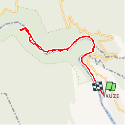
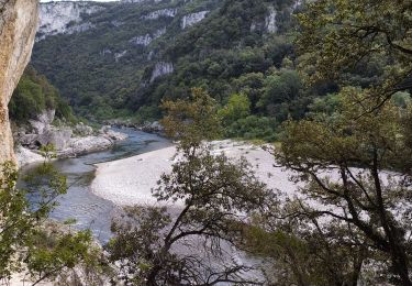
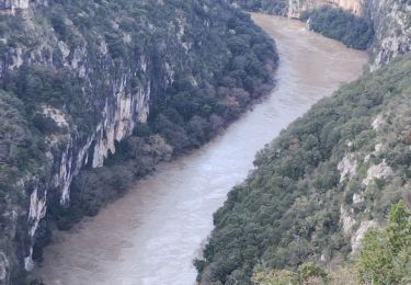
Trail Walking of 12.4 km to be discovered at Auvergne-Rhône-Alpes, Ardèche, Saint-Martin-d'Ardèche. This trail is proposed by kephas.
Description
Aller et retour dans les gorges de L'Ardèche.
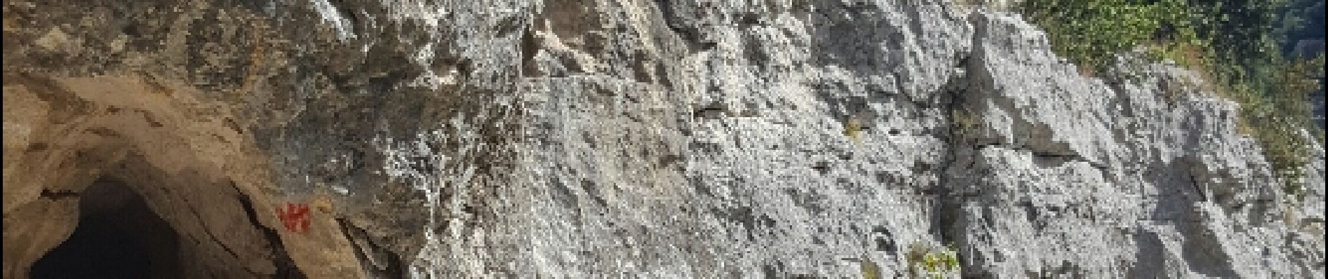
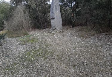
Des passages aménagés avec échelles.
Ne pas effectuer les jours de pluie, roches glissantes
Positioning
Country:
France
Region :
Auvergne-Rhône-Alpes
Department/Province :
Ardèche
Municipality :
Saint-Martin-d'Ardèche
Location:
Unknown
Start:(Dec)
Start:(UTM)
623869 ; 4907656 (31T) N.
Comments
Trails nearby
![Trail Walking Saint-Martin-d'Ardèche - GR4 Aigueze - Photo](https://media.geolcdn.com/t/375/260/ext.jpg?maxdim=2&url=https%3A%2F%2Fservices.sitytrail.com%2FGeolivesWS%2FDownloadMedia.ashx%3FTrailID%3D325544%26Media%3Dfix__20140709163308.jpg)
![Walking Walking](https://static1.geolcdn.com/sitytour/trail-icons/101.png)
GR4 Aigueze
Walking
Medium
(1)
Saint-Martin-d'Ardèche,
Auvergne-Rhône-Alpes,
Ardèche,
France
![](/images/other/stat-length.png)
12.6 km | 17 km-effort
4h 39min
![](https://static1.geolcdn.com/siteimages/upload/files/16400158638029165_repeat_loop_refresh_sync_direction_icon.png)
Yes
![Trail Walking Aiguèze - 30 aigueze ribeirol - Photo](https://media.geolcdn.com/t/375/260/a5de248d-2217-49e5-9c57-d3e37cd5f6c4.jpg&format=jpg&maxdim=2)
![Walking Walking](https://static1.geolcdn.com/sitytour/trail-icons/101.png)
30 aigueze ribeirol
Walking
Difficult
Aiguèze,
Occitania,
Gard,
France
![](/images/other/stat-length.png)
10.7 km | 16.4 km-effort
6h 26min
![](https://static1.geolcdn.com/siteimages/upload/files/16400158638029165_repeat_loop_refresh_sync_direction_icon.png)
Yes
![Trail Walking Saint-Martin-d'Ardèche - Aigueze rocher de Castelviel - Photo](https://media.geolcdn.com/t/375/260/416d7ebd-2359-4463-8249-a90d2272e98d.jpg&format=jpg&maxdim=2)
![Walking Walking](https://static1.geolcdn.com/sitytour/trail-icons/101.png)
Aigueze rocher de Castelviel
Walking
Easy
Saint-Martin-d'Ardèche,
Auvergne-Rhône-Alpes,
Ardèche,
France
![](/images/other/stat-length.png)
12.5 km | 16.8 km-effort
4h 11min
![](https://static1.geolcdn.com/siteimages/upload/files/16400158638029165_repeat_loop_refresh_sync_direction_icon.png)
Yes
![Trail Walking Saint-Martin-d'Ardèche - Sauze bivouac de Gournier - Photo](https://media.geolcdn.com/t/375/260/baac8ebe-8937-4db4-b6c4-7e0bd115b9f1.jpg&format=jpg&maxdim=2)
![Walking Walking](https://static1.geolcdn.com/sitytour/trail-icons/101.png)
Sauze bivouac de Gournier
Walking
Medium
Saint-Martin-d'Ardèche,
Auvergne-Rhône-Alpes,
Ardèche,
France
![](/images/other/stat-length.png)
14.9 km | 25 km-effort
4h 3min
![](https://static1.geolcdn.com/siteimages/upload/files/16400158638029165_repeat_loop_refresh_sync_direction_icon.png)
No
![Trail Walking Saint-Martin-d'Ardèche - 07 st martin d ardeche gorge ardeche - Photo](https://media.geolcdn.com/t/375/260/fdc113c1-1a01-412d-be10-a6b4f2c87d8a.jpg&format=jpg&maxdim=2)
![Walking Walking](https://static1.geolcdn.com/sitytour/trail-icons/101.png)
07 st martin d ardeche gorge ardeche
Walking
Medium
Saint-Martin-d'Ardèche,
Auvergne-Rhône-Alpes,
Ardèche,
France
![](/images/other/stat-length.png)
17.2 km | 25 km-effort
6h 36min
![](https://static1.geolcdn.com/siteimages/upload/files/16400158638029165_repeat_loop_refresh_sync_direction_icon.png)
Yes
![Trail Walking Aiguèze - Aigueze - Photo](https://media.geolcdn.com/t/375/260/e7b8de9a-d915-48ca-baac-0319f593dc54.jpg&format=jpg&maxdim=2)
![Walking Walking](https://static1.geolcdn.com/sitytour/trail-icons/101.png)
![Trail Walking Saint-Martin-d'Ardèche - Saint Martin d’Ardéche - Photo](https://media.geolcdn.com/t/375/260/b543bd48-15f1-4b47-a933-7d4f79f7128e.jpg&format=jpg&maxdim=2)
![Walking Walking](https://static1.geolcdn.com/sitytour/trail-icons/101.png)
Saint Martin d’Ardéche
Walking
Difficult
Saint-Martin-d'Ardèche,
Auvergne-Rhône-Alpes,
Ardèche,
France
![](/images/other/stat-length.png)
12.6 km | 16.8 km-effort
5h 3min
![](https://static1.geolcdn.com/siteimages/upload/files/16400158638029165_repeat_loop_refresh_sync_direction_icon.png)
No
![Trail On foot Aiguèze - FR-PR 24 - Photo](https://media.geolcdn.com/t/375/260/adb231a8-9d03-4c90-9261-a3c9f3c8fd1c.jpeg&format=jpg&maxdim=2)
![On foot On foot](https://static1.geolcdn.com/sitytour/trail-icons/100.png)
![Trail Walking Aiguèze - aigueze - Photo](https://media.geolcdn.com/t/375/260/9a8e66bd-28b9-4786-9840-dbf6e6fca8cf.jpg&format=jpg&maxdim=2)
![Walking Walking](https://static1.geolcdn.com/sitytour/trail-icons/101.png)
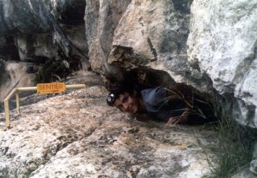
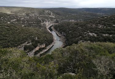
Parcours difficile pour sportif confirmé. Ne pas faire seul en cas de canicule.