![](/images/other/stat-length.png)
![Trail Walking Malaucène - LE TOULOURENC - RANDO SEMI AQUATIQUE - Photo](https://media.geolcdn.com/t/1900/400/ext.pjpeg?maxdim=2&url=https%3A%2F%2Fstatic1.geolcdn.com%2Fsiteimages%2Fupload%2Ffiles%2F1553511878bg_sport_marche.png)
LE TOULOURENC - RANDO SEMI AQUATIQUE
NICOLLETMICHEL
User
![Length](/images/other/stat-length.png)
![Max alt](https://static1.geolcdn.com/siteimages/upload/files/1508320355ic_sort_altitude_max_24dp.png)
![Uphill gradient](https://static1.geolcdn.com/siteimages/upload/files/1508320355ic_sort_den_pos_24dp.png)
![Km-Effort](/images/other/stat-length.png)
![Min alt](https://static1.geolcdn.com/siteimages/upload/files/1508320355ic_sort_altitude_min_24dp.png)
![Downhill gradient](https://static1.geolcdn.com/siteimages/upload/files/1508320355ic_sort_den_neg_24dp.png)
![Boucle](https://static1.geolcdn.com/siteimages/upload/files/16400158638029165_repeat_loop_refresh_sync_direction_icon.png)
![Walking](https://static1.geolcdn.com/sitytour/trail-icons/101.png)
4h18
Difficulty : Medium
![Scan this QR Code to open this trail in the SityTrail application](https://capi.geolives.com/qq0zvz2zws4bq2lad0pu/sitytour/trails/630644/qr.png?size=200)
FREE GPS app for hiking
About
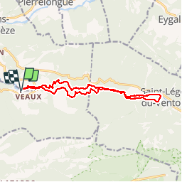
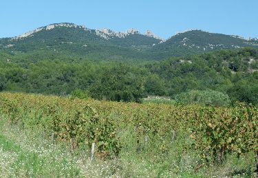
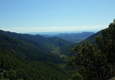
Trail Walking of 14.5 km to be discovered at Provence-Alpes-Côte d'Azur, Vaucluse, Malaucène. This trail is proposed by NICOLLETMICHEL.
Description
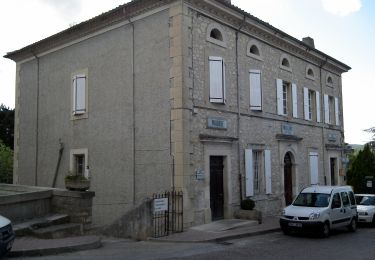
Depuis le village de Malaucène, prendre la D242 en direction du hameau de Vaux. Laissez votre véhicule 300 mètres avant le hameau sur le parking aménagé dans les champs .
Depuis le parking rejoindre la rivière et la remonter à pied pour dépasser la maison que l'on voit sur notre gauche , chien et propriétaire très peu accueillant ensuite prendre le GR 91 en direction de Saint Léger du Ventoux. Large au début, la piste laisse place au fur et à mesure de l’ascension à un chemin plus étroit. Après 30 minutes, le point culminant à 540 m est atteint au niveau de la balise «les gorges du Toulourenc ». Poursuivre en direction de Saint Léger par un agréable sentier en balcon offrant de belles vue sur la rivière. ...
Continuer, le chemin redescend vers la rivière, et quand voyez un pont, traversez le et continuer sur l'autre rive .
Quand vous arrivez en vue de St léger du Depuis le pont, prendre le GR91 en direction de Saint Léger du Ventoux. Large au début, la piste laisse place au fur et à mesure de l’ascension à un chemin plus étroit. Après 30 minutes, on atteint le point culminant à 540m . Poursuivre en direction de Saint Léger par un agréable sentier en balcon offrant de belles vue sur la rivière. ... Ventoux, rejoignez la rivière et redescendez la jusqu'au point de départ .
Prévoir des sachets étanches pour téléphone et autre, maillot de bain, et baskets pour marcher dans l’eau.
Passages un peu délicat dans des chaos rocheux au milieu de l'eau !
Superbe balade à faire de Juin à Septembre, ne pas y aller après ou en cas de risque d’orage.
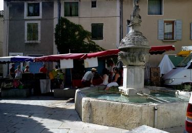
Nous étions 16, tout le monde a adoré.
Positioning
Comments
Trails nearby
![Trail Walking Entrechaux - Entrechaux en Vaucluse - Photo](https://media.geolcdn.com/t/375/260/ext.jpg?maxdim=2&url=https%3A%2F%2Fservices.sitytrail.com%2FGeolivesWS%2FDownloadMedia.ashx%3FTrailID%3D107158%26Media%3D12001_3.jpg)
![Walking Walking](https://static1.geolcdn.com/sitytour/trail-icons/101.png)
Walking
![](/images/other/stat-length.png)
![](https://static1.geolcdn.com/siteimages/upload/files/16400158638029165_repeat_loop_refresh_sync_direction_icon.png)
![Trail Walking Beaumont-du-Ventoux - Sentier de découverte au Mont Serein - Photo](https://media.geolcdn.com/t/375/260/ext.jpg?maxdim=2&url=https%3A%2F%2Fservices.sitytrail.com%2FGeolivesWS%2FDownloadMedia.ashx%3FTrailID%3D103767%26Media%3D6520_2.jpg)
![Walking Walking](https://static1.geolcdn.com/sitytour/trail-icons/101.png)
Walking
![](/images/other/stat-length.png)
![](https://static1.geolcdn.com/siteimages/upload/files/16400158638029165_repeat_loop_refresh_sync_direction_icon.png)
![Trail On foot Mollans-sur-Ouvèze - Roubion - Photo](https://media.geolcdn.com/t/375/260/acc73179-5e12-4051-b44f-b0980aab9979.jpeg&format=jpg&maxdim=2)
![On foot On foot](https://static1.geolcdn.com/sitytour/trail-icons/100.png)
On foot
![](/images/other/stat-length.png)
![](https://static1.geolcdn.com/siteimages/upload/files/16400158638029165_repeat_loop_refresh_sync_direction_icon.png)
![Trail On foot Mollans-sur-Ouvèze - Pisserouille - Photo](https://media.geolcdn.com/t/375/260/acc73179-5e12-4051-b44f-b0980aab9979.jpeg&format=jpg&maxdim=2)
![On foot On foot](https://static1.geolcdn.com/sitytour/trail-icons/100.png)
On foot
![](/images/other/stat-length.png)
![](https://static1.geolcdn.com/siteimages/upload/files/16400158638029165_repeat_loop_refresh_sync_direction_icon.png)
![Trail On foot Mollans-sur-Ouvèze - Crête et Ubac de Bluye - Photo](https://media.geolcdn.com/t/375/260/1f6fc386-d1d3-46f5-84c8-16749c58c4c0.jpeg&format=jpg&maxdim=2)
![On foot On foot](https://static1.geolcdn.com/sitytour/trail-icons/100.png)
On foot
![](/images/other/stat-length.png)
![](https://static1.geolcdn.com/siteimages/upload/files/16400158638029165_repeat_loop_refresh_sync_direction_icon.png)
![Trail On foot Mollans-sur-Ouvèze - Adret de Bluye - Photo](https://media.geolcdn.com/t/375/260/1f6fc386-d1d3-46f5-84c8-16749c58c4c0.jpeg&format=jpg&maxdim=2)
![On foot On foot](https://static1.geolcdn.com/sitytour/trail-icons/100.png)
On foot
![](/images/other/stat-length.png)
![](https://static1.geolcdn.com/siteimages/upload/files/16400158638029165_repeat_loop_refresh_sync_direction_icon.png)
![Trail On foot Mollans-sur-Ouvèze - Mollans - Pierrelongue - Photo](https://media.geolcdn.com/t/375/260/acc73179-5e12-4051-b44f-b0980aab9979.jpeg&format=jpg&maxdim=2)
![On foot On foot](https://static1.geolcdn.com/sitytour/trail-icons/100.png)
On foot
![](/images/other/stat-length.png)
![](https://static1.geolcdn.com/siteimages/upload/files/16400158638029165_repeat_loop_refresh_sync_direction_icon.png)
![Trail Walking Mollans-sur-Ouvèze - mollans-sur-ouveze-2019 - Photo](https://media.geolcdn.com/t/375/260/ext.jpg?maxdim=2&url=https%3A%2F%2Fstatic1.geolcdn.com%2Fsiteimages%2Fupload%2Ffiles%2F1553511878bg_sport_marche.png)
![Walking Walking](https://static1.geolcdn.com/sitytour/trail-icons/101.png)
Walking
![](/images/other/stat-length.png)
![](https://static1.geolcdn.com/siteimages/upload/files/16400158638029165_repeat_loop_refresh_sync_direction_icon.png)
![Trail Walking Beaumont-du-Ventoux - Ascension du Ventoux versant nord - Photo](https://media.geolcdn.com/t/375/260/22f53a61-90b8-424b-b027-8242692a4006.jpg&format=jpg&maxdim=2)
![Walking Walking](https://static1.geolcdn.com/sitytour/trail-icons/101.png)
Walking
![](/images/other/stat-length.png)
![](https://static1.geolcdn.com/siteimages/upload/files/16400158638029165_repeat_loop_refresh_sync_direction_icon.png)