![](/images/other/stat-length.png)
![Trail Walking Allons - pic de chamatte par crête des serres - Photo](https://media.geolcdn.com/t/1900/400/ext.pjpeg?maxdim=2&url=https%3A%2F%2Fservices.sitytrail.com%2FGeolivesWS%2FDownloadMedia.ashx%3FTrailID%3D630173%26Media%3Dfix__20160912101515.jpg)
pic de chamatte par crête des serres
daniel256
User
![Length](/images/other/stat-length.png)
Length
21 km
![Max alt](https://static1.geolcdn.com/siteimages/upload/files/1508320355ic_sort_altitude_max_24dp.png)
Max alt
1839 m
![Uphill gradient](https://static1.geolcdn.com/siteimages/upload/files/1508320355ic_sort_den_pos_24dp.png)
Uphill gradient
1046 m
![Km-Effort](/images/other/stat-length.png)
Km-Effort
35 km
![Min alt](https://static1.geolcdn.com/siteimages/upload/files/1508320355ic_sort_altitude_min_24dp.png)
Min alt
1043 m
![Downhill gradient](https://static1.geolcdn.com/siteimages/upload/files/1508320355ic_sort_den_neg_24dp.png)
Downhill gradient
1040 m
![Boucle](https://static1.geolcdn.com/siteimages/upload/files/16400158638029165_repeat_loop_refresh_sync_direction_icon.png)
Boucle
Yes
Creation date :
2016-09-12 00:00:00.0
Updated on :
2016-09-12 00:00:00.0
![Walking](https://static1.geolcdn.com/sitytour/trail-icons/101.png)
5h07
Difficulty : Medium
![Scan this QR Code to open this trail in the SityTrail application](https://capi.geolives.com/qq0zvz2zws4bq2lad0pu/sitytour/trails/630173/qr.png?size=200)
FREE GPS app for hiking
About
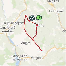
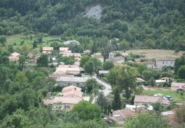
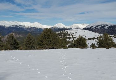
Trail Walking of 21 km to be discovered at Provence-Alpes-Côte d'Azur, Alpes-de-Haute-Provence, Allons. This trail is proposed by daniel256.
Description
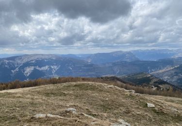
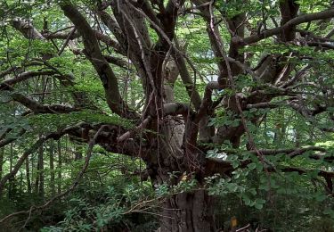
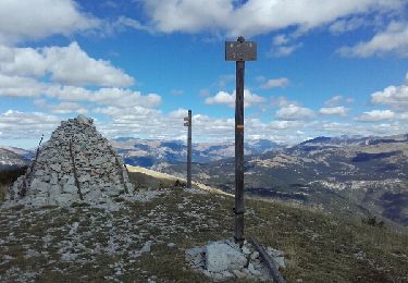
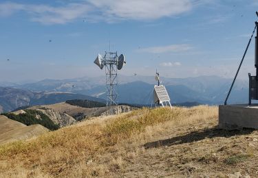
montée dans une magnifique hêtraie, puis long passage sur la crête jusqu'au pic, avec tout du long un superbe panorama, descente par la basse d'angls
Positioning
Country:
France
Region :
Provence-Alpes-Côte d'Azur
Department/Province :
Alpes-de-Haute-Provence
Municipality :
Allons
Location:
Unknown
Start:(Dec)
Start:(UTM)
306220 ; 4872474 (32T) N.
Comments
Trails nearby
![Trail Walking Allons - 2024-11-29 Pic de Chamatte par Allons - Photo](https://media.geolcdn.com/t/375/260/97311ce2-81b2-4947-a084-db12309544ec.jpg&format=jpg&maxdim=2)
![Walking Walking](https://static1.geolcdn.com/sitytour/trail-icons/101.png)
2024-11-29 Pic de Chamatte par Allons
Walking
Very difficult
Allons,
Provence-Alpes-Côte d'Azur,
Alpes-de-Haute-Provence,
France
![](/images/other/stat-length.png)
15.6 km | 27 km-effort
6h 8min
![](https://static1.geolcdn.com/siteimages/upload/files/16400158638029165_repeat_loop_refresh_sync_direction_icon.png)
Yes
![Trail Walking Méailles - M’égailles tête du Ruch - Photo](https://media.geolcdn.com/t/375/260/401bfe9f-c51e-4875-aec2-03cd717ee019.jpg&format=jpg&maxdim=2)
![Walking Walking](https://static1.geolcdn.com/sitytour/trail-icons/101.png)
M’égailles tête du Ruch
Walking
Very difficult
Méailles,
Provence-Alpes-Côte d'Azur,
Alpes-de-Haute-Provence,
France
![](/images/other/stat-length.png)
19.9 km | 37 km-effort
8h 38min
![](https://static1.geolcdn.com/siteimages/upload/files/16400158638029165_repeat_loop_refresh_sync_direction_icon.png)
Yes
![Trail Walking Annot - Rando bleue - Photo](https://media.geolcdn.com/t/375/260/94ab7e9b-3b20-4840-b15c-d5a4c12ad390.jpg&format=jpg&maxdim=2)
![Walking Walking](https://static1.geolcdn.com/sitytour/trail-icons/101.png)
Rando bleue
Walking
Easy
Annot,
Provence-Alpes-Côte d'Azur,
Alpes-de-Haute-Provence,
France
![](/images/other/stat-length.png)
3.9 km | 5.8 km-effort
1h 22min
![](https://static1.geolcdn.com/siteimages/upload/files/16400158638029165_repeat_loop_refresh_sync_direction_icon.png)
Yes
![On foot On foot](https://static1.geolcdn.com/sitytour/trail-icons/100.png)
2021-09-20_Le Fugeret
On foot
Medium
Le Fugeret,
Provence-Alpes-Côte d'Azur,
Alpes-de-Haute-Provence,
France
![](/images/other/stat-length.png)
11.2 km | 19.7 km-effort
4h 28min
![](https://static1.geolcdn.com/siteimages/upload/files/16400158638029165_repeat_loop_refresh_sync_direction_icon.png)
Yes
![Trail Walking Allons - Rando de l'arbre remarquable - Photo](https://media.geolcdn.com/t/375/260/aaef36be-2d70-4d78-b5d4-9afc331a74b1.jpg&format=jpg&maxdim=2)
![Walking Walking](https://static1.geolcdn.com/sitytour/trail-icons/101.png)
Rando de l'arbre remarquable
Walking
Easy
Allons,
Provence-Alpes-Côte d'Azur,
Alpes-de-Haute-Provence,
France
![](/images/other/stat-length.png)
9.2 km | 12.7 km-effort
2h 19min
![](https://static1.geolcdn.com/siteimages/upload/files/16400158638029165_repeat_loop_refresh_sync_direction_icon.png)
Yes
![Trail Walking Allons - puy de rent, descente par la colle - Photo](https://media.geolcdn.com/t/375/260/ext.jpg?maxdim=2&url=https%3A%2F%2Fservices.sitytrail.com%2FGeolivesWS%2FDownloadMedia.ashx%3FTrailID%3D658591%26Media%3Dfix__20160920124101.jpg)
![Walking Walking](https://static1.geolcdn.com/sitytour/trail-icons/101.png)
puy de rent, descente par la colle
Walking
Medium
Allons,
Provence-Alpes-Côte d'Azur,
Alpes-de-Haute-Provence,
France
![](/images/other/stat-length.png)
22 km | 38 km-effort
5h 40min
![](https://static1.geolcdn.com/siteimages/upload/files/16400158638029165_repeat_loop_refresh_sync_direction_icon.png)
Yes
![Trail Walking Angles - angles chamate 914m 14kms - Photo](https://media.geolcdn.com/t/375/260/c6c7251d-723c-4cc2-933d-3f046b74f1f8.jpg&format=jpg&maxdim=2)
![Walking Walking](https://static1.geolcdn.com/sitytour/trail-icons/101.png)
angles chamate 914m 14kms
Walking
Medium
Angles,
Provence-Alpes-Côte d'Azur,
Alpes-de-Haute-Provence,
France
![](/images/other/stat-length.png)
13.7 km | 25 km-effort
6h 17min
![](https://static1.geolcdn.com/siteimages/upload/files/16400158638029165_repeat_loop_refresh_sync_direction_icon.png)
Yes
![Trail Walking La Mure-Argens - La mure montagne de maurel 950m 14kms - Photo](https://media.geolcdn.com/t/375/260/b7d3a1ee-5851-4e36-b585-17e43856c469.jpg&format=jpg&maxdim=2)
![Walking Walking](https://static1.geolcdn.com/sitytour/trail-icons/101.png)
La mure montagne de maurel 950m 14kms
Walking
Medium
La Mure-Argens,
Provence-Alpes-Côte d'Azur,
Alpes-de-Haute-Provence,
France
![](/images/other/stat-length.png)
13 km | 24 km-effort
6h 57min
![](https://static1.geolcdn.com/siteimages/upload/files/16400158638029165_repeat_loop_refresh_sync_direction_icon.png)
Yes
![Trail Walking Allons - colle Basse - Photo](https://media.geolcdn.com/t/375/260/c4582884-2a59-4331-9e1f-4bdd5d6ce425.jpg&format=jpg&maxdim=2)
![Walking Walking](https://static1.geolcdn.com/sitytour/trail-icons/101.png)
colle Basse
Walking
Very easy
Allons,
Provence-Alpes-Côte d'Azur,
Alpes-de-Haute-Provence,
France
![](/images/other/stat-length.png)
3.8 km | 4.5 km-effort
1h 11min
![](https://static1.geolcdn.com/siteimages/upload/files/16400158638029165_repeat_loop_refresh_sync_direction_icon.png)
Yes