Trail Walking Saint-Martin-du-Puy - Rando Morvan - 3 jours - Photo
 Fab-Oz
Fab-Oz

User

© OpenStreetMap contributors
Length
Length
69 km
Max alt
Max alt
637 m
Uphill gradient
Uphill gradient
1788 m
Km-Effort
Km-Effort  
93 km
Min alt
Min alt
349 m
Downhill gradient
Downhill gradient
1782 m
Boucle
Boucle
Yes
Creation date :
2019-05-10 09:07:00.098
Updated on :
2019-05-10 09:07:02.297

(0 Reviews)

Walking
Walking
16h40
Difficulty : Difficult

Scan this QR Code to open this trail in the SityTrail application

FREE GPS app for hiking

Logo SityTrail SityTrail

IGN / Geographical institutes

Download SityTrail from the App Store Download SityTrail from Google Play

Logo SityTrail SityTrail World

The world is yours!

Download SityTrail from the App Store Download SityTrail from Google Play Download SityTrail on Huawei AppGallery

About

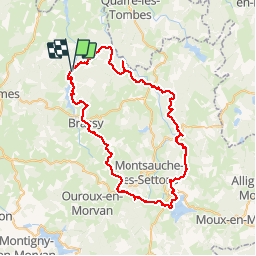
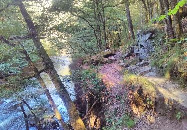
Trail Walking of 69 km to be discovered at Bourgogne-Franche-Comté, Nièvre, Saint-Martin-du-Puy. This trail is proposed by Fab-Oz.

Description

Boucle dans le Morvan - 3 jours

Jour 1 : jeudi soir (7km)
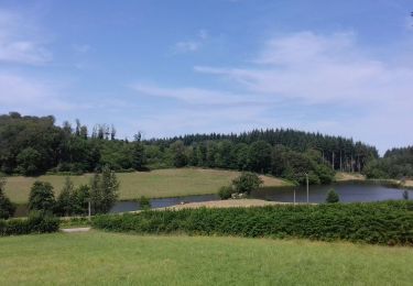
- départ du Chalaux vers le barrage de Chaumeçon
- bivouac vers la Chaume aux Renards

Jour 2 : vendredi (32km)
- départ de la chaume aux Renards
- le Vieux Dun
- A/R fontaine Saint-Marc pour ravitaillement eau
- déjeuner forêt du Breuil-Chenue
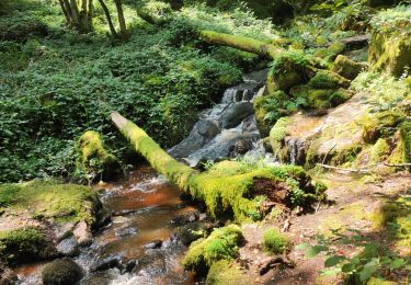
- baignade au Saut de Gouloux
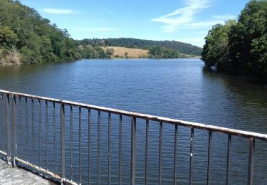
- bivouac au lac des Settons

Jour 3 : samedi (29km)
- départ lac des Settons
- liaison GR13/GRP tour du Morvan
- GRP par Savault Fonteny Brassy
- retour au barrage de Chaumeçon
- bivouac au bord du Chalaux

Jour 4 : dimanche matin
- Rafting 5km sur le Chalaux

Elevation profile

Points of interest

Point of interest Marigny-l'Église - Fin Jour 1 - Photo
Fab-Oz
MARIGNY-L'ÉGLISE 
Point of interest Montsauche-les-Settons - Fin Jour 2 - Photo
Fab-Oz
MONTSAUCHE-LES-SETTONS 

Positioning

Country:
France
Region :
Bourgogne-Franche-Comté
Department/Province :
Nièvre
Municipality :
Saint-Martin-du-Puy
Location:
Unknown
Start:(UTM)
569405 ; 5239908 (31T) N.

Trails nearby

Trail Walking Saint-Martin-du-Puy - Montcrecon -lac de Crescent - Chalaux - 7/2020 - Photo
Walking
nicolibris

Walking

Medium
(1)
Saint-Martin-du-Puy, Bourgogne-Franche-Comté, Nièvre, France
9.4 km | 12.5 km-effort
4h 6min
Yes
Trail Walking Saint-Martin-du-Puy - Tour de Saint-Martin-du-Puy - Photo
Walking
nicolibris

Walking

Medium
Saint-Martin-du-Puy, Bourgogne-Franche-Comté, Nièvre, France
10.6 km | 13.8 km-effort
3h 53min
Yes
Trail Walking Saint-Martin-du-Puy - beaucoup trop dure - Photo
Walking
Honoré Duval

Walking

Very difficult
Saint-Martin-du-Puy, Bourgogne-Franche-Comté, Nièvre, France
35 km | 48 km-effort
8h 9min
No
Trail Walking Quarré-les-Tombes - La Cure - Photo
Walking
RAY25

Walking

Very difficult
Quarré-les-Tombes, Bourgogne-Franche-Comté, Yonne, France
19.2 km | 27 km-effort
6h 8min
Yes
Trail Equestrian Quarré-les-Tombes - Arrivée du chalaux - Photo
Equestrian
balmesc

Equestrian

Medium
Quarré-les-Tombes, Bourgogne-Franche-Comté, Yonne, France
24 km | 33 km-effort
4h 53min
Yes
Trail Walking Quarré-les-Tombes - iles menefriers  - Photo
Walking
dadodeca

Walking

Medium
Quarré-les-Tombes, Bourgogne-Franche-Comté, Yonne, France
12.1 km | 16 km-effort
3h 18min
Yes
Trail Walking Saint-Martin-du-Puy - Rando Morvan - Photo
Walking
Fab-Oz

Walking

Difficult
Saint-Martin-du-Puy, Bourgogne-Franche-Comté, Nièvre, France
69 km | 95 km-effort
18h 49min
Yes
Trail Walking Saint-Martin-du-Puy - Saint Martin du Puy - Photo
Walking
tracegps

Walking

Difficult
Saint-Martin-du-Puy, Bourgogne-Franche-Comté, Nièvre, France
12.5 km | 16.4 km-effort
4h 0min
Yes
Trail Walking Brassy - Sommée - Lormes- Station sismique - Photo
Walking
tracegps

Walking

Difficult
Brassy, Bourgogne-Franche-Comté, Nièvre, France
15 km | 21 km-effort
4h 40min
Yes


Close
My subscriptions