Trail Other activity Passy - Lac de Pormenaz - Photo
© OpenStreetMap contributors
Length
Length
9.9 km
Max alt
Max alt
1963 m
Uphill gradient
Uphill gradient
730 m
Km-Effort
Km-Effort  
19.6 km
Min alt
Min alt
1278 m
Downhill gradient
Downhill gradient
731 m
Boucle
Boucle
Yes
Creation date :
2016-09-12 00:00:00.0
Updated on :
2016-09-12 00:00:00.0

(0 Reviews)

Other activity
Other activity
5h00
Difficulty : Medium

Scan this QR Code to open this trail in the SityTrail application

FREE GPS app for hiking

Logo SityTrail SityTrail

IGN / Geographical institutes

Download SityTrail from the App Store Download SityTrail from Google Play

Logo SityTrail SityTrail World

The world is yours!

Download SityTrail from the App Store Download SityTrail from Google Play Download SityTrail on Huawei AppGallery

About

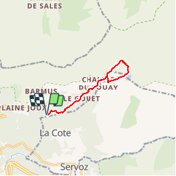
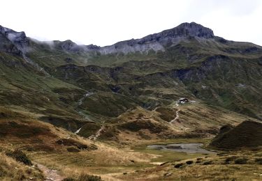
Trail Other activity of 9.9 km to be discovered at Auvergne-Rhône-Alpes, Upper Savoy, Passy. This trail is proposed by christophe7406.

Description

Dép Lac vert-Chatelet-La Chorde-Lac de pornemaz-L'argentiere

Elevation profile

Positioning

Country:
France
Region :
Auvergne-Rhône-Alpes
Department/Province :
Upper Savoy
Municipality :
Passy
Location:
Unknown
Start:(UTM)
325892 ; 5090815 (32T) N.

Trails nearby

Trail Walking Passy - Tour des Ayères - Passy Plaine-Joux - Photo
Walking
tracegps

Walking

Medium
(6)
Passy, Auvergne-Rhône-Alpes, Upper Savoy, France
9 km | 14.3 km-effort
2h 30min
Yes
Trail Walking Passy - Plaine Joux Barmus Ayères Lac Vert  - Photo
Walking
GUIDE
Kargil

Walking

Very easy
(1)
Passy, Auvergne-Rhône-Alpes, Upper Savoy, France
7.6 km | 12.2 km-effort
2h 18min
Yes
Trail Walking Passy - Plaine Joux-Passage du derochoir-Col de Portette-Platé - Photo
Walking
GUIDE
Kargil

Walking

Difficult
Passy, Auvergne-Rhône-Alpes, Upper Savoy, France
14.4 km | 30 km-effort
6h 42min
Yes
Trail Running Passy - grimpe de chedde ayeres - Photo
Running
winbat11

Running

Very easy
(1)
Passy, Auvergne-Rhône-Alpes, Upper Savoy, France
15 km | 28 km-effort
2h 46min
No
Trail Walking Les Houches - J14 - R13 - La statue du Christ Roi - Photo
Walking
GUIDE
mumu.larandonneuse

Walking

Medium
Les Houches, Auvergne-Rhône-Alpes, Upper Savoy, France
2.3 km | 5.2 km-effort
56min
Yes
Trail Walking Sixt-Fer-à-Cheval - Le tour des Fiz : J3 - Photo
Walking
Greg813

Walking

Medium
Sixt-Fer-à-Cheval, Auvergne-Rhône-Alpes, Upper Savoy, France
10.8 km | 21 km-effort
3h 24min
No
Trail Walking Passy - Le tour des Fiz : J1 - Photo
Walking
Greg813

Walking

Medium
Passy, Auvergne-Rhône-Alpes, Upper Savoy, France
12.9 km | 26 km-effort
4h 3min
No
Trail Walking Les Houches - boucle aiguillette des houches ,refuge bel-lachat - Photo
Walking
carton-fils@orange.fr

Walking

Very difficult
Les Houches, Auvergne-Rhône-Alpes, Upper Savoy, France
10.4 km | 24 km-effort
2h 49min
Yes
Trail Walking Les Houches - échec refuge de bellachat - Photo
Walking
carton-fils@orange.fr

Walking

Medium
Les Houches, Auvergne-Rhône-Alpes, Upper Savoy, France
3.9 km | 8.1 km-effort
2h 38min
Yes


Close
My subscriptions