Trail Walking Entrevennes - Entrevennes (boucle) - Photo
© OpenStreetMap contributors
Length
Length
11.7 km
Max alt
Max alt
691 m
Uphill gradient
Uphill gradient
149 m
Km-Effort
Km-Effort  
13.6 km
Min alt
Min alt
605 m
Downhill gradient
Downhill gradient
149 m
Boucle
Boucle
Yes
Creation date :
2016-09-11 00:00:00.0
Updated on :
2016-09-11 00:00:00.0

(0 Reviews)

Walking
Walking
2h59
Difficulty : Very easy

Scan this QR Code to open this trail in the SityTrail application

FREE GPS app for hiking

Logo SityTrail SityTrail

IGN / Geographical institutes

Download SityTrail from the App Store Download SityTrail from Google Play

Logo SityTrail SityTrail World

The world is yours!

Download SityTrail from the App Store Download SityTrail from Google Play Download SityTrail on Huawei AppGallery

About

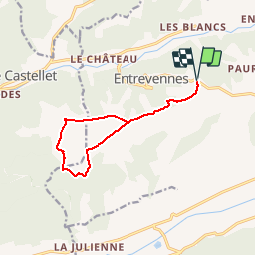
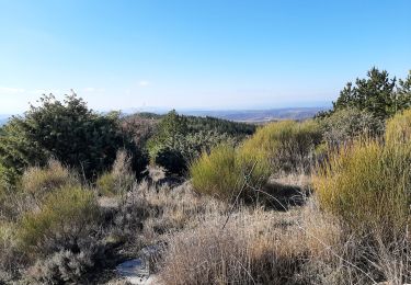
Trail Walking of 11.7 km to be discovered at Provence-Alpes-Côte d'Azur, Alpes-de-Haute-Provence, Entrevennes. This trail is proposed by bmilliard.

Description

Du cote d'entrevennes
En quete du plateau Grémone
(balades litteraires a la rencontre de Jean Giono)

Elevation profile

Positioning

Country:
France
Region :
Provence-Alpes-Côte d'Azur
Department/Province :
Alpes-de-Haute-Provence
Municipality :
Entrevennes
Location:
Unknown
Start:(UTM)
262378 ; 4869161 (32T) N.

Trails nearby

Trail Walking Puimichel - Le castellet. puimichel  - Photo
Walking
Roger

Walking

Medium
Puimichel, Provence-Alpes-Côte d'Azur, Alpes-de-Haute-Provence, France
10.4 km | 14.2 km-effort
3h 24min
Yes
Trail Walking Le Castellet - ENTREVENNES . TOUR DU COLOMBIER n - Photo
Walking
RobinMicheline

Walking

Medium
Le Castellet, Provence-Alpes-Côte d'Azur, Alpes-de-Haute-Provence, France
18.7 km | 23 km-effort
4h 19min
Yes
Trail Walking Puimichel - Randonnée à Puimichel - Photo
Walking
tracegps

Walking

Easy
(3)
Puimichel, Provence-Alpes-Côte d'Azur, Alpes-de-Haute-Provence, France
8.6 km | 12.7 km-effort
3h 0min
Yes
Trail Walking Saint-Julien-d'Asse - 2024-02-06 Saint Julien d Asse - Photo
Walking
GUIDE
Kargil

Walking

Easy
(1)
Saint-Julien-d'Asse, Provence-Alpes-Côte d'Azur, Alpes-de-Haute-Provence, France
14.4 km | 20 km-effort
4h 33min
Yes
Trail Walking Puimichel - PUIMICHEL.  AUTOUR DE PUIMICHEL . O . L - Photo
Walking
RobinMicheline

Walking

Medium
Puimichel, Provence-Alpes-Côte d'Azur, Alpes-de-Haute-Provence, France
9.1 km | 13.1 km-effort
2h 19min
Yes
Trail Walking Puimichel - puimichel. les antelmes - Photo
Walking
Roger

Walking

Easy
Puimichel, Provence-Alpes-Côte d'Azur, Alpes-de-Haute-Provence, France
6.9 km | 9.7 km-effort
2h 15min
Yes
Trail Walking Entrevennes - ensales  . ajonc - Photo
Walking
Jemasa9

Walking

Easy
Entrevennes, Provence-Alpes-Côte d'Azur, Alpes-de-Haute-Provence, France
7.2 km | 9.7 km-effort
2h 13min
Yes
Trail Walking Saint-Jeannet - Le Somme  du plateau  d entrevenne  - Photo
Walking
Jemasa9

Walking

Medium
Saint-Jeannet, Provence-Alpes-Côte d'Azur, Alpes-de-Haute-Provence, France
10.4 km | 14.7 km-effort
4h 21min
Yes
Trail Walking Puimichel - pui2 - Photo
Walking
Orres

Walking

Easy
Puimichel, Provence-Alpes-Côte d'Azur, Alpes-de-Haute-Provence, France
3.9 km | 5.3 km-effort
1h 13min
No


Close
My subscriptions