![](/images/other/stat-length.png)
Orsonnette_ND_Mailhat
jagarnier
User GUIDE
![Length](/images/other/stat-length.png)
![Max alt](https://static1.geolcdn.com/siteimages/upload/files/1508320355ic_sort_altitude_max_24dp.png)
![Uphill gradient](https://static1.geolcdn.com/siteimages/upload/files/1508320355ic_sort_den_pos_24dp.png)
![Km-Effort](/images/other/stat-length.png)
![Min alt](https://static1.geolcdn.com/siteimages/upload/files/1508320355ic_sort_altitude_min_24dp.png)
![Downhill gradient](https://static1.geolcdn.com/siteimages/upload/files/1508320355ic_sort_den_neg_24dp.png)
![Boucle](https://static1.geolcdn.com/siteimages/upload/files/16400158638029165_repeat_loop_refresh_sync_direction_icon.png)
![Walking](https://static1.geolcdn.com/sitytour/trail-icons/101.png)
2h30
Difficulty : Easy
![Scan this QR Code to open this trail in the SityTrail application](https://capi.geolives.com/qq0zvz2zws4bq2lad0pu/sitytour/trails/627042/qr.png?size=200)
FREE GPS app for hiking
About
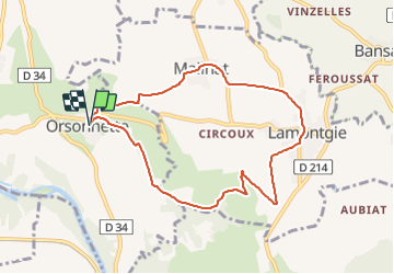
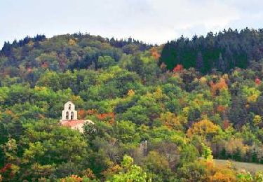
Trail Walking of 8.4 km to be discovered at Auvergne-Rhône-Alpes, Puy-de-Dôme, Nonette-Orsonnette. This trail is proposed by jagarnier.
Description
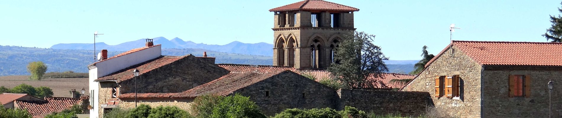
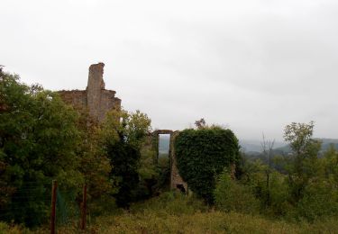
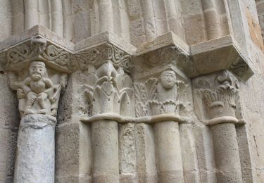
L'église de Mailhat a été construite sur un temple gallo-romain par les moines de Sauxillanges à la fin du XIIe siècle. Cette église, d'un style élégant et orné, tranche avec la sévérité du roman auvergnat.
Vous emprunterez par endroits le chemin de Saint Jacques de Compostelle qui relie Clermont à Cahors.
Positioning
Comments
Trails nearby
![Trail Walking Auzat-la-Combelle - Auzat_Croix - Photo](https://media.geolcdn.com/t/375/260/e2705c59-d58f-4cbd-838f-c8fc6c94cee6.jpg&format=jpg&maxdim=2)
![Walking Walking](https://static1.geolcdn.com/sitytour/trail-icons/101.png)
Walking
![](/images/other/stat-length.png)
![](https://static1.geolcdn.com/siteimages/upload/files/16400158638029165_repeat_loop_refresh_sync_direction_icon.png)
![Trail Walking Les Pradeaux - De l'Allier à l'Ailloux - Photo](https://media.geolcdn.com/t/375/260/ext.jpg?maxdim=2&url=https%3A%2F%2Fservices.sitytrail.com%2FGeolivesWS%2FDownloadMedia.ashx%3FTrailID%3D102201%26Media%3D2601_1.jpg)
![Walking Walking](https://static1.geolcdn.com/sitytour/trail-icons/101.png)
Walking
![](/images/other/stat-length.png)
![](https://static1.geolcdn.com/siteimages/upload/files/16400158638029165_repeat_loop_refresh_sync_direction_icon.png)
![Trail On foot Jumeaux - Saint Jean Saint Gervais - Photo](https://media.geolcdn.com/t/375/260/d91975ea-58a4-4680-ae17-9c879cbe7b59.jpeg&format=jpg&maxdim=2)
![On foot On foot](https://static1.geolcdn.com/sitytour/trail-icons/100.png)
On foot
![](/images/other/stat-length.png)
![](https://static1.geolcdn.com/siteimages/upload/files/16400158638029165_repeat_loop_refresh_sync_direction_icon.png)
![Trail On foot Esteil - La Croix d'Auzat - Photo](https://media.geolcdn.com/t/375/260/a2a90937-45ee-4416-ac6e-d9a9a8350e15.jpeg&format=jpg&maxdim=2)
![On foot On foot](https://static1.geolcdn.com/sitytour/trail-icons/100.png)
On foot
![](/images/other/stat-length.png)
![](https://static1.geolcdn.com/siteimages/upload/files/16400158638029165_repeat_loop_refresh_sync_direction_icon.png)
![Trail On foot Lamontgie - Notre-Dame de Mailhat - Photo](https://media.geolcdn.com/t/375/260/8569347c-98a0-4a8f-9e69-27a1e8ebd4a8.jpeg&format=jpg&maxdim=2)
![On foot On foot](https://static1.geolcdn.com/sitytour/trail-icons/100.png)
On foot
![](/images/other/stat-length.png)
![](https://static1.geolcdn.com/siteimages/upload/files/16400158638029165_repeat_loop_refresh_sync_direction_icon.png)
![Trail On foot Saint-Martin-des-Plains - Vallee de parcelles - Photo](https://media.geolcdn.com/t/375/260/c8678a81-89dc-4bd7-aa82-46bb9b00d226.jpeg&format=jpg&maxdim=2)
![On foot On foot](https://static1.geolcdn.com/sitytour/trail-icons/100.png)
On foot
![](/images/other/stat-length.png)
![](https://static1.geolcdn.com/siteimages/upload/files/16400158638029165_repeat_loop_refresh_sync_direction_icon.png)
![Trail Walking Saint-Germain-Lembron - Entre béal et pigeonniers - Saint Germain Lembron - Photo](https://media.geolcdn.com/t/375/260/ext.jpg?maxdim=2&url=https%3A%2F%2Fstatic1.geolcdn.com%2Fsiteimages%2Fupload%2Ffiles%2F1553511878bg_sport_marche.png)
![Walking Walking](https://static1.geolcdn.com/sitytour/trail-icons/101.png)
Walking
![](/images/other/stat-length.png)
![](https://static1.geolcdn.com/siteimages/upload/files/16400158638029165_repeat_loop_refresh_sync_direction_icon.png)
![Trail Walking Nonette-Orsonnette - Nonette_Val_Allier - Photo](https://media.geolcdn.com/t/375/260/6af492ac-412f-4f8d-b1d7-92987ee0d659.jpg&format=jpg&maxdim=2)
![Walking Walking](https://static1.geolcdn.com/sitytour/trail-icons/101.png)
Walking
![](/images/other/stat-length.png)
![](https://static1.geolcdn.com/siteimages/upload/files/16400158638029165_repeat_loop_refresh_sync_direction_icon.png)
![Trail Walking Jumeaux - Jumeaux_St_Jean - Photo](https://media.geolcdn.com/t/375/260/9ac38bfa-955d-4c21-9bd6-1ea2c878fdb6.jpg&format=jpg&maxdim=2)
![Walking Walking](https://static1.geolcdn.com/sitytour/trail-icons/101.png)
Walking
![](/images/other/stat-length.png)
![](https://static1.geolcdn.com/siteimages/upload/files/16400158638029165_repeat_loop_refresh_sync_direction_icon.png)