Trail Walking Saint-Vérand - La Gaucherie - Photo
 dan48
dan48

User

© OpenStreetMap contributors
Length
Length
10.4 km
Max alt
Max alt
470 m
Uphill gradient
Uphill gradient
342 m
Km-Effort
Km-Effort  
14.9 km
Min alt
Min alt
288 m
Downhill gradient
Downhill gradient
344 m
Boucle
Boucle
Yes
Creation date :
2016-09-06 00:00:00.0
Updated on :
2016-09-06 00:00:00.0

(0 Reviews)

Walking
Walking
3h00
Difficulty : Medium

Scan this QR Code to open this trail in the SityTrail application

FREE GPS app for hiking

Logo SityTrail SityTrail

IGN / Geographical institutes

Download SityTrail from the App Store Download SityTrail from Google Play

Logo SityTrail SityTrail World

The world is yours!

Download SityTrail from the App Store Download SityTrail from Google Play Download SityTrail on Huawei AppGallery

About

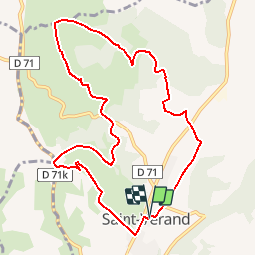
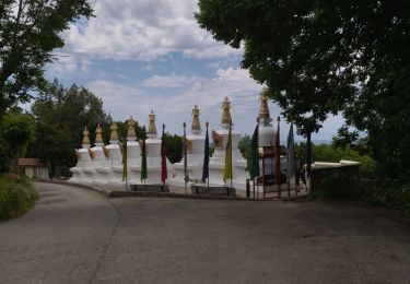
Trail Walking of 10.4 km to be discovered at Auvergne-Rhône-Alpes, Isère, Saint-Vérand. This trail is proposed by dan48.

Description

Sur PR du pays de St-Marcellin, mais le balisage est parfois difficile à suivre ; la trace GPS est utile...

Elevation profile

Positioning

Country:
France
Region :
Auvergne-Rhône-Alpes
Department/Province :
Isère
Municipality :
Saint-Vérand
Location:
Unknown
Start:(UTM)
683359 ; 5004921 (31T) N.

Trails nearby

Trail Mountain bike Chatte - De Chatte à St Antoine en passant par Chevrière - Photo
Mountain bike
gilder89

Mountain bike

Very difficult
(1)
Chatte, Auvergne-Rhône-Alpes, Isère, France
44 km | 60 km-effort
3h 53min
Yes
Trail Road bike Chatte - chatte2 - Photo
Road bike
BELLETGE

Road bike

Very easy
(1)
Chatte, Auvergne-Rhône-Alpes, Isère, France
57 km | 71 km-effort
3h 18min
Yes
Trail Walking Varacieux - Combe Robert depuis Essemat - Photo
Walking
crocau

Walking

Easy
(1)
Varacieux, Auvergne-Rhône-Alpes, Isère, France
4.4 km | 5.9 km-effort
1h 35min
Yes
Trail Walking Vinay - Château de la Blache - Photo
Walking
crocau

Walking

Very easy
Vinay, Auvergne-Rhône-Alpes, Isère, France
2.9 km | 3.3 km-effort
50min
Yes
Trail Walking Izeron - 38 izeron - Photo
Walking
randodyssée

Walking

Medium
Izeron, Auvergne-Rhône-Alpes, Isère, France
15.8 km | 30 km-effort
6h 39min
Yes
Trail Mountain bike Chatte - chemin du tram part1 - Photo
Mountain bike
Julien Rodriguez

Mountain bike

Very easy
Chatte, Auvergne-Rhône-Alpes, Isère, France
11.4 km | 14.1 km-effort
1h 16min
Yes
Trail Walking Chevrières - Chevrieres fêtas - Photo
Walking
michelineguillot

Walking

Easy
(1)
Chevrières, Auvergne-Rhône-Alpes, Isère, France
13.3 km | 18 km-effort
3h 14min
Yes
Trail Walking Chatte - CHATTE - Photo
Walking
000151.528cee2ba5ea499bb7720e62b4a3eb52.0056

Walking

Difficult
Chatte, Auvergne-Rhône-Alpes, Isère, France
10.6 km | 12.1 km-effort
1h 42min
Yes
Trail Walking Chatte - Chatte - Photo
Walking
000151.528cee2ba5ea499bb7720e62b4a3eb52.0056

Walking

Medium
Chatte, Auvergne-Rhône-Alpes, Isère, France
10.2 km | 11.9 km-effort
1h 41min
Yes


Close
My subscriptions