![](/images/other/stat-length.png)
![Trail Walking Lans-en-Vercors - Le Pic Saint Michel - Photo](https://media.geolcdn.com/t/1900/400/ext.pjpeg?maxdim=2&url=https%3A%2F%2Fservices.sitytrail.com%2FGeolivesWS%2FDownloadMedia.ashx%3FTrailID%3D619669%26Media%3Dfix__20160823121146.jpg)
Le Pic Saint Michel
SabetMick
User
![Length](/images/other/stat-length.png)
Length
9.6 km
![Max alt](https://static1.geolcdn.com/siteimages/upload/files/1508320355ic_sort_altitude_max_24dp.png)
Max alt
1938 m
![Uphill gradient](https://static1.geolcdn.com/siteimages/upload/files/1508320355ic_sort_den_pos_24dp.png)
Uphill gradient
667 m
![Km-Effort](/images/other/stat-length.png)
Km-Effort
18.5 km
![Min alt](https://static1.geolcdn.com/siteimages/upload/files/1508320355ic_sort_altitude_min_24dp.png)
Min alt
1286 m
![Downhill gradient](https://static1.geolcdn.com/siteimages/upload/files/1508320355ic_sort_den_neg_24dp.png)
Downhill gradient
670 m
![Boucle](https://static1.geolcdn.com/siteimages/upload/files/16400158638029165_repeat_loop_refresh_sync_direction_icon.png)
Boucle
Yes
Creation date :
2018-09-16 13:50:18.726
Updated on :
2018-09-16 13:50:18.771
![Walking](https://static1.geolcdn.com/sitytour/trail-icons/101.png)
4h59
Difficulty : Medium
![Scan this QR Code to open this trail in the SityTrail application](https://capi.geolives.com/qq0zvz2zws4bq2lad0pu/sitytour/trails/619669/qr.png?size=200)
FREE GPS app for hiking
About
Trail Walking of 9.6 km to be discovered at Auvergne-Rhône-Alpes, Isère, Lans-en-Vercors. This trail is proposed by SabetMick.
Description
Superbe rando offrant de magnifiques panoramas sur la vallée de Grenoble et toutes les Alpes. Une bonne ascension pour commencer, mais les efforts sont tout de suite recompensés.
Positioning
Country:
France
Region :
Auvergne-Rhône-Alpes
Department/Province :
Isère
Municipality :
Lans-en-Vercors
Location:
Unknown
Start:(Dec)
Start:(UTM)
704827 ; 4998178 (31T) N.
Comments
Trails nearby
![Trail Walking Lans-en-Vercors - 38 pic st michel - Photo](https://media.geolcdn.com/t/375/260/cfeb7787-6d5b-45db-91c6-1feb93d2f73c.jpg&format=jpg&maxdim=2)
![Walking Walking](https://static1.geolcdn.com/sitytour/trail-icons/101.png)
38 pic st michel
Walking
Easy
(1)
Lans-en-Vercors,
Auvergne-Rhône-Alpes,
Isère,
France
![](/images/other/stat-length.png)
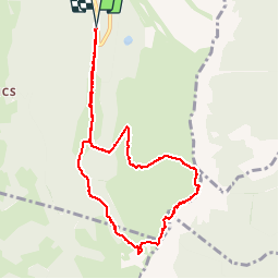
8.7 km | 17.3 km-effort
5h 16min
![](https://static1.geolcdn.com/siteimages/upload/files/16400158638029165_repeat_loop_refresh_sync_direction_icon.png)
Yes
![Trail Snowshoes Lans-en-Vercors - La Crête des Ramées de nuit en raquettes - Photo](https://media.geolcdn.com/t/375/260/ext.jpg?maxdim=2&url=https%3A%2F%2Fservices.sitytrail.com%2FGeolivesWS%2FDownloadMedia.ashx%3FTrailID%3D897155%26Media%3Dfix__20180130203527.jpg)
![Snowshoes Snowshoes](https://static1.geolcdn.com/sitytour/trail-icons/504.png)
La Crête des Ramées de nuit en raquettes
Snowshoes
Medium
(1)
Lans-en-Vercors,
Auvergne-Rhône-Alpes,
Isère,
France
![](/images/other/stat-length.png)
8 km | 13.4 km-effort
4h 9min
![](https://static1.geolcdn.com/siteimages/upload/files/16400158638029165_repeat_loop_refresh_sync_direction_icon.png)
Yes
![Trail Walking Lans-en-Vercors - Le Pic saint michel - Photo](https://media.geolcdn.com/t/375/260/ext.jpg?maxdim=2&url=https%3A%2F%2Fservices.sitytrail.com%2FGeolivesWS%2FDownloadMedia.ashx%3FTrailID%3D205024%26Media%3Dfix__20130714151209.jpg)
![Walking Walking](https://static1.geolcdn.com/sitytour/trail-icons/101.png)
Le Pic saint michel
Walking
Easy
(1)
Lans-en-Vercors,
Auvergne-Rhône-Alpes,
Isère,
France
![](/images/other/stat-length.png)
6.5 km | 13.2 km-effort
2h 38min
![](https://static1.geolcdn.com/siteimages/upload/files/16400158638029165_repeat_loop_refresh_sync_direction_icon.png)
No
![Trail Walking Lans-en-Vercors - le vertige des cimes - Photo](https://media.geolcdn.com/t/375/260/2d2e8455-1754-4db8-b9ed-75845d14fe6a.jpg&format=jpg&maxdim=2)
![Walking Walking](https://static1.geolcdn.com/sitytour/trail-icons/101.png)
le vertige des cimes
Walking
Medium
(1)
Lans-en-Vercors,
Auvergne-Rhône-Alpes,
Isère,
France
![](/images/other/stat-length.png)
6.3 km | 11 km-effort
2h 9min
![](https://static1.geolcdn.com/siteimages/upload/files/16400158638029165_repeat_loop_refresh_sync_direction_icon.png)
Yes
![Trail Walking Villard-de-Lans - cabane de robon - Photo](https://media.geolcdn.com/t/375/260/f81b29b4-5a6d-4db9-85aa-f42275b30a70.jpg&format=jpg&maxdim=2)
![Walking Walking](https://static1.geolcdn.com/sitytour/trail-icons/101.png)
cabane de robon
Walking
Very easy
(1)
Villard-de-Lans,
Auvergne-Rhône-Alpes,
Isère,
France
![](/images/other/stat-length.png)
10.2 km | 15.8 km-effort
5h 25min
![](https://static1.geolcdn.com/siteimages/upload/files/16400158638029165_repeat_loop_refresh_sync_direction_icon.png)
Yes
![Trail Walking Lans-en-Vercors - Lans - Belvédère Vertige des Cimes depuis Le Furon - Photo](https://media.geolcdn.com/t/375/260/ext.jpg?maxdim=2&url=https%3A%2F%2Fservices.sitytrail.com%2FGeolivesWS%2FDownloadMedia.ashx%3FTrailID%3D661434%26Media%3Dfix__20161117114034.jpg)
![Walking Walking](https://static1.geolcdn.com/sitytour/trail-icons/101.png)
Lans - Belvédère Vertige des Cimes depuis Le Furon
Walking
Medium
(1)
Lans-en-Vercors,
Auvergne-Rhône-Alpes,
Isère,
France
![](/images/other/stat-length.png)
8 km | 15.9 km-effort
3h 9min
![](https://static1.geolcdn.com/siteimages/upload/files/16400158638029165_repeat_loop_refresh_sync_direction_icon.png)
Yes
![Trail Snowshoes Lans-en-Vercors - Le Pic Saint-Michel en raquettes (2012) - Photo](https://media.geolcdn.com/t/375/260/ext.jpg?maxdim=2&url=https%3A%2F%2Fservices.sitytrail.com%2FGeolivesWS%2FDownloadMedia.ashx%3FTrailID%3D107676%26Media%3D12680_1.jpg)
![Snowshoes Snowshoes](https://static1.geolcdn.com/sitytour/trail-icons/504.png)
Le Pic Saint-Michel en raquettes (2012)
Snowshoes
Medium
(2)
Lans-en-Vercors,
Auvergne-Rhône-Alpes,
Isère,
France
![](/images/other/stat-length.png)
8.4 km | 17.3 km-effort
5h 0min
![](https://static1.geolcdn.com/siteimages/upload/files/16400158638029165_repeat_loop_refresh_sync_direction_icon.png)
Yes
![Trail Walking Lans-en-Vercors - La Grande Roche Saint-Michel, depuis Furon - Photo](https://media.geolcdn.com/t/375/260/ext.jpg?maxdim=2&url=https%3A%2F%2Fservices.sitytrail.com%2FGeolivesWS%2FDownloadMedia.ashx%3FTrailID%3D103768%26Media%3D6521_1.jpg)
![Walking Walking](https://static1.geolcdn.com/sitytour/trail-icons/101.png)
La Grande Roche Saint-Michel, depuis Furon
Walking
Easy
(1)
Lans-en-Vercors,
Auvergne-Rhône-Alpes,
Isère,
France
![](/images/other/stat-length.png)
8.4 km | 17.1 km-effort
4h 0min
![](https://static1.geolcdn.com/siteimages/upload/files/16400158638029165_repeat_loop_refresh_sync_direction_icon.png)
Yes
![Trail Walking Villard-de-Lans - Le Plateau du Cornafion 1906m - Photo](https://media.geolcdn.com/t/375/260/ext.jpg?maxdim=2&url=https%3A%2F%2Fservices.sitytrail.com%2FGeolivesWS%2FDownloadMedia.ashx%3FTrailID%3D101491%26Media%3D1596_1.jpg)
![Walking Walking](https://static1.geolcdn.com/sitytour/trail-icons/101.png)
Le Plateau du Cornafion 1906m
Walking
Difficult
(1)
Villard-de-Lans,
Auvergne-Rhône-Alpes,
Isère,
France
![](/images/other/stat-length.png)
7.8 km | 17.7 km-effort
4h 30min
![](https://static1.geolcdn.com/siteimages/upload/files/16400158638029165_repeat_loop_refresh_sync_direction_icon.png)
Yes