Trail Walking Baudrémont - BAUDREMONT LA BARJOT - Photo

BAUDREMONT LA BARJOT

 cath310
cath310

User

© OpenStreetMap contributors
Length
Length
14.6 km
Max alt
Max alt
358 m
Uphill gradient
Uphill gradient
186 m
Km-Effort
Km-Effort  
17.1 km
Min alt
Min alt
268 m
Downhill gradient
Downhill gradient
186 m
Boucle
Boucle
Yes
Creation date :
2016-08-21 00:00:00.0
Updated on :
2016-08-21 00:00:00.0

(0 Reviews)

Walking
Walking
3h44
Difficulty : Easy

Scan this QR Code to open this trail in the SityTrail application

FREE GPS app for hiking

Logo SityTrail SityTrail

IGN / Geographical institutes

Download SityTrail from the App Store Download SityTrail from Google Play

Logo SityTrail SityTrail World

The world is yours!

Download SityTrail from the App Store Download SityTrail from Google Play Download SityTrail on Huawei AppGallery

About

Trail Walking of 14.6 km to be discovered at Grand Est, Meuse, Baudrémont. This trail is proposed by cath310.

Description

BAUDREMONT LA BARJOT 2016
D/R Eglise
tps indiqué avec pause

Elevation profile

Positioning

Country:
France
Region :
Grand Est
Department/Province :
Meuse
Municipality :
Baudrémont
Location:
Unknown
Start:(UTM)
675160 ; 5412435 (31U) N.

Trails nearby

Trail Walking Baudrémont - BAUDREMONT GRP VAL DE MEUSE  - Photo
Walking
cath310

Walking

Easy
(1)
Baudrémont, Grand Est, Meuse, France
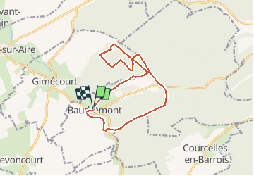
19.8 km | 24 km-effort
4h 56min
Yes
Trail Walking Rupt-devant-Saint-Mihiel - koeur - Photo
Walking
aderas

Walking

Easy
Rupt-devant-Saint-Mihiel, Grand Est, Meuse, France
9.1 km | 10.8 km-effort
1h 56min
No
Trail Walking Nicey-sur-Aire - Limites terrains Nicey - Photo
Walking
lauurentd

Walking

Very easy
Nicey-sur-Aire, Grand Est, Meuse, France
1 km | 1.2 km-effort
10min
No


Close
My subscriptions