![](/images/other/stat-length.png)
![Trail Walking Auzat - Pinet - Montcalm - Photo](https://media.geolcdn.com/t/1900/400/ext.pjpeg?maxdim=2&url=https%3A%2F%2Fstatic1.geolcdn.com%2Fsiteimages%2Fupload%2Ffiles%2F1553511878bg_sport_marche.png)
Pinet - Montcalm
baruc
User
![Length](/images/other/stat-length.png)
Length
13.7 km
![Max alt](https://static1.geolcdn.com/siteimages/upload/files/1508320355ic_sort_altitude_max_24dp.png)
Max alt
3070 m
![Uphill gradient](https://static1.geolcdn.com/siteimages/upload/files/1508320355ic_sort_den_pos_24dp.png)
Uphill gradient
859 m
![Km-Effort](/images/other/stat-length.png)
Km-Effort
29 km
![Min alt](https://static1.geolcdn.com/siteimages/upload/files/1508320355ic_sort_altitude_min_24dp.png)
Min alt
1170 m
![Downhill gradient](https://static1.geolcdn.com/siteimages/upload/files/1508320355ic_sort_den_neg_24dp.png)
Downhill gradient
1922 m
![Boucle](https://static1.geolcdn.com/siteimages/upload/files/16400158638029165_repeat_loop_refresh_sync_direction_icon.png)
Boucle
No
Creation date :
2016-08-08 00:00:00.0
Updated on :
2016-08-08 00:00:00.0
![Walking](https://static1.geolcdn.com/sitytour/trail-icons/101.png)
5h07
Difficulty : Difficult
![Scan this QR Code to open this trail in the SityTrail application](https://capi.geolives.com/qq0zvz2zws4bq2lad0pu/sitytour/trails/610946/qr.png?size=200)
FREE GPS app for hiking
About
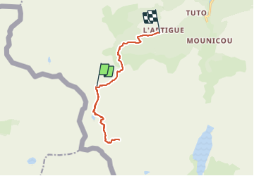
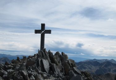
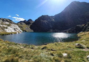
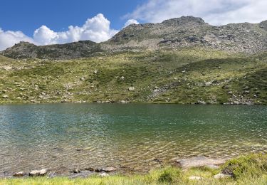
Trail Walking of 13.7 km to be discovered at Occitania, Ariège, Auzat. This trail is proposed by baruc.
Description
Une bonne ballade du refuge du Pinet jusqu'au Montcalm et retour au parking de l'Artigue.
La veille (parcours non enregistré), nous avons été très bien accueillis par les gardiens du refuge.
Positioning
Country:
France
Region :
Occitania
Department/Province :
Ariège
Municipality :
Auzat
Location:
Unknown
Start:(Dec)
Start:(UTM)
368545 ; 4727758 (31T) N.
Comments
Trails nearby
![Trail Walking Auzat - Le Picot - Photo](https://media.geolcdn.com/t/375/260/ext.jpg?maxdim=2&url=https%3A%2F%2Fservices.sitytrail.com%2FGeolivesWS%2FDownloadMedia.ashx%3FTrailID%3D218307%26Media%3D7d32352a-7ee3-4817-a78f-8417168ce812.JPG)
![Walking Walking](https://static1.geolcdn.com/sitytour/trail-icons/101.png)
![Trail Walking Auzat - Les étangs de la Gardelle - Auzat - Photo](https://media.geolcdn.com/t/375/260/ext.jpg?maxdim=2&url=https%3A%2F%2Fstatic1.geolcdn.com%2Fsiteimages%2Fupload%2Ffiles%2F1553511878bg_sport_marche.png)
![Walking Walking](https://static1.geolcdn.com/sitytour/trail-icons/101.png)
Les étangs de la Gardelle - Auzat
Walking
Difficult
(2)
Auzat,
Occitania,
Ariège,
France
![](/images/other/stat-length.png)
8.3 km | 21 km-effort
6h 0min
![](https://static1.geolcdn.com/siteimages/upload/files/16400158638029165_repeat_loop_refresh_sync_direction_icon.png)
Yes
![Trail Walking Auzat - Pica d'Estats et Montcalm - Photo](https://media.geolcdn.com/t/375/260/b8816478-8edb-416a-9fa8-a319d1040721.jpeg&format=jpg&maxdim=2)
![Walking Walking](https://static1.geolcdn.com/sitytour/trail-icons/101.png)
Pica d'Estats et Montcalm
Walking
Very difficult
Auzat,
Occitania,
Ariège,
France
![](/images/other/stat-length.png)
18.8 km | 46 km-effort
10h 23min
![](https://static1.geolcdn.com/siteimages/upload/files/16400158638029165_repeat_loop_refresh_sync_direction_icon.png)
Yes
![Trail Walking Auzat - Domaine de Montcalm -port Rat Pic Rouge - Photo](https://media.geolcdn.com/t/375/260/4ee9492f-31eb-4d1a-b77c-878ac1f5c4df.jpg&format=jpg&maxdim=2)
![Walking Walking](https://static1.geolcdn.com/sitytour/trail-icons/101.png)
Domaine de Montcalm -port Rat Pic Rouge
Walking
Very difficult
Auzat,
Occitania,
Ariège,
France
![](/images/other/stat-length.png)
17.1 km | 39 km-effort
10h 8min
![](https://static1.geolcdn.com/siteimages/upload/files/16400158638029165_repeat_loop_refresh_sync_direction_icon.png)
Yes
![Trail Walking Auzat - Tour des lacs - Sarroucanes - Photo](https://media.geolcdn.com/t/375/260/45e48d9e-2f03-4378-bfe0-01a4ae1719c1.jpg&format=jpg&maxdim=2)
![Walking Walking](https://static1.geolcdn.com/sitytour/trail-icons/101.png)
Tour des lacs - Sarroucanes
Walking
Very difficult
Auzat,
Occitania,
Ariège,
France
![](/images/other/stat-length.png)
16 km | 0 m-effort
8h 42min
![](https://static1.geolcdn.com/siteimages/upload/files/16400158638029165_repeat_loop_refresh_sync_direction_icon.png)
No
![Trail Walking Auzat - Caraussans - Photo](https://media.geolcdn.com/t/375/260/13f3c7b9-396a-4438-ab57-e6debb7e127e.jpg&format=jpg&maxdim=2)
![Walking Walking](https://static1.geolcdn.com/sitytour/trail-icons/101.png)
Caraussans
Walking
Very difficult
Auzat,
Occitania,
Ariège,
France
![](/images/other/stat-length.png)
19.6 km | 41 km-effort
9h 16min
![](https://static1.geolcdn.com/siteimages/upload/files/16400158638029165_repeat_loop_refresh_sync_direction_icon.png)
Yes
![Trail Walking Auzat - Boucle etangs de la Gardelle - Photo](https://media.geolcdn.com/t/375/260/fb25dd7f-b9c3-45ab-85f7-b885de72aafa.jpg&format=jpg&maxdim=2)
![Walking Walking](https://static1.geolcdn.com/sitytour/trail-icons/101.png)
Boucle etangs de la Gardelle
Walking
Difficult
Auzat,
Occitania,
Ariège,
France
![](/images/other/stat-length.png)
10.9 km | 23 km-effort
4h 45min
![](https://static1.geolcdn.com/siteimages/upload/files/16400158638029165_repeat_loop_refresh_sync_direction_icon.png)
Yes
![Trail Walking Auzat - Randonnée des étangs de Sarroucane au pic de la rouge - Photo](https://media.geolcdn.com/t/375/260/f17fb008-7179-415e-98f2-2332757e6c02.jpg&format=jpg&maxdim=2)
![Walking Walking](https://static1.geolcdn.com/sitytour/trail-icons/101.png)
Randonnée des étangs de Sarroucane au pic de la rouge
Walking
Very difficult
(1)
Auzat,
Occitania,
Ariège,
France
![](/images/other/stat-length.png)
16 km | 34 km-effort
8h 1min
![](https://static1.geolcdn.com/siteimages/upload/files/16400158638029165_repeat_loop_refresh_sync_direction_icon.png)
Yes
![Trail Walking Auzat - pic de Malcaras - Photo](https://media.geolcdn.com/t/375/260/28063895-9915-45ee-8ca9-95e3b31bb91e.jpg&format=jpg&maxdim=2)
![Walking Walking](https://static1.geolcdn.com/sitytour/trail-icons/101.png)
pic de Malcaras
Walking
Difficult
Auzat,
Occitania,
Ariège,
France
![](/images/other/stat-length.png)
7.6 km | 23 km-effort
6h 59min
![](https://static1.geolcdn.com/siteimages/upload/files/16400158638029165_repeat_loop_refresh_sync_direction_icon.png)
Yes