![](/images/other/stat-length.png)
![Trail Walking Bourg-Saint-Maurice - Du refuge de la croix du bonhomme au refuge de Presset - Photo](https://media.geolcdn.com/t/1900/400/ext.pjpeg?maxdim=2&url=https%3A%2F%2Fservices.sitytrail.com%2FGeolivesWS%2FDownloadMedia.ashx%3FTrailID%3D609388%26Media%3D8a31b606-40ae-4d95-9c57-2a2f84368645.jpg)
Du refuge de la croix du bonhomme au refuge de Presset
Desrumaux
User GUIDE
![Length](/images/other/stat-length.png)
Length
14.6 km
![Max alt](https://static1.geolcdn.com/siteimages/upload/files/1508320355ic_sort_altitude_max_24dp.png)
Max alt
2671 m
![Uphill gradient](https://static1.geolcdn.com/siteimages/upload/files/1508320355ic_sort_den_pos_24dp.png)
Uphill gradient
923 m
![Km-Effort](/images/other/stat-length.png)
Km-Effort
27 km
![Min alt](https://static1.geolcdn.com/siteimages/upload/files/1508320355ic_sort_altitude_min_24dp.png)
Min alt
1752 m
![Downhill gradient](https://static1.geolcdn.com/siteimages/upload/files/1508320355ic_sort_den_neg_24dp.png)
Downhill gradient
868 m
![Boucle](https://static1.geolcdn.com/siteimages/upload/files/16400158638029165_repeat_loop_refresh_sync_direction_icon.png)
Boucle
No
Creation date :
2016-08-06 00:00:00.0
Updated on :
2016-08-06 00:00:00.0
![Walking](https://static1.geolcdn.com/sitytour/trail-icons/101.png)
5h26
Difficulty : Medium
![Scan this QR Code to open this trail in the SityTrail application](https://capi.geolives.com/qq0zvz2zws4bq2lad0pu/sitytour/trails/609388/qr.png?size=200)
FREE GPS app for hiking
About
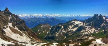
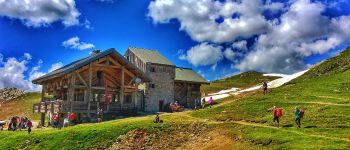
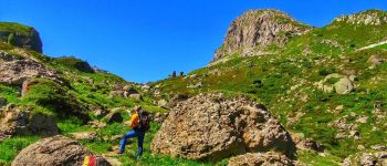
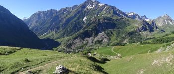
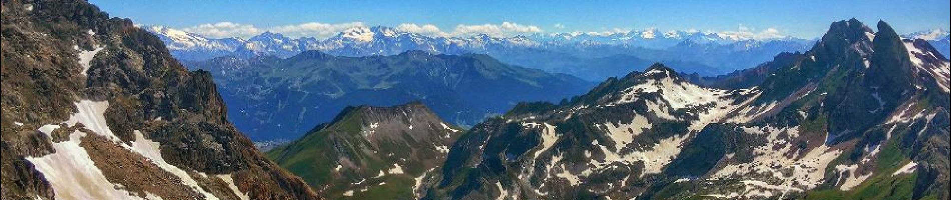
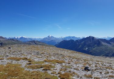
Trail Walking of 14.6 km to be discovered at Auvergne-Rhône-Alpes, Savoy, Bourg-Saint-Maurice. This trail is proposed by Desrumaux.
Description
Randonnée dans le massif du Beaufortain, du refuge de la croix du bonhomme au refuge de Presset par la Combe de la Neuva et le col du Grand Fond
Positioning
Country:
France
Region :
Auvergne-Rhône-Alpes
Department/Province :
Savoy
Municipality :
Bourg-Saint-Maurice
Location:
Unknown
Start:(Dec)
Start:(UTM)
322434 ; 5065689 (32T) N.
Comments
Trails nearby
![Trail Walking Beaufort - Du refuge du Plan de la laie au refuge de la Croix du Bonhomme - Photo](https://media.geolcdn.com/t/375/260/ext.jpg?maxdim=2&url=https%3A%2F%2Fservices.sitytrail.com%2FGeolivesWS%2FDownloadMedia.ashx%3FTrailID%3D605207%26Media%3D510e5eef-7385-455b-8e69-ea984ac16f39.jpg)
![Walking Walking](https://static1.geolcdn.com/sitytour/trail-icons/101.png)
Du refuge du Plan de la laie au refuge de la Croix du Bonhomme
Walking
Medium
(1)
Beaufort,
Auvergne-Rhône-Alpes,
Savoy,
France
![](/images/other/stat-length.png)
8 km | 16 km-effort
4h 27min
![](https://static1.geolcdn.com/siteimages/upload/files/16400158638029165_repeat_loop_refresh_sync_direction_icon.png)
No
![Trail Walking Bourg-Saint-Maurice - suuntoapp-Hiking-2024-09-10T06-18-18Z - Photo](https://media.geolcdn.com/t/375/260/2ffa221c-2b68-468e-ba02-fb43d145165a.jpg&format=jpg&maxdim=2)
![Walking Walking](https://static1.geolcdn.com/sitytour/trail-icons/101.png)
suuntoapp-Hiking-2024-09-10T06-18-18Z
Walking
Very difficult
Bourg-Saint-Maurice,
Auvergne-Rhône-Alpes,
Savoy,
France
![](/images/other/stat-length.png)
16.7 km | 28 km-effort
6h 27min
![](https://static1.geolcdn.com/siteimages/upload/files/16400158638029165_repeat_loop_refresh_sync_direction_icon.png)
No
![Trail Touring skiing Bourg-Saint-Maurice - autour du lac de Mya - Photo](https://media.geolcdn.com/t/375/260/4ac04904-2253-423b-b6ac-3f3b6564cfe2.jpg&format=jpg&maxdim=2)
![Touring skiing Touring skiing](https://static1.geolcdn.com/sitytour/trail-icons/503.png)
autour du lac de Mya
Touring skiing
Easy
Bourg-Saint-Maurice,
Auvergne-Rhône-Alpes,
Savoy,
France
![](/images/other/stat-length.png)
10.1 km | 25 km-effort
4h 42min
![](https://static1.geolcdn.com/siteimages/upload/files/16400158638029165_repeat_loop_refresh_sync_direction_icon.png)
No
![Trail Touring skiing Beaufort - Passage d'Arpire, col Bresson, brèche de Parozan - Photo](https://media.geolcdn.com/t/375/260/cef576dc-81b5-4e18-a375-2d133cd76090.jpg&format=jpg&maxdim=2)
![Touring skiing Touring skiing](https://static1.geolcdn.com/sitytour/trail-icons/503.png)
Passage d'Arpire, col Bresson, brèche de Parozan
Touring skiing
Difficult
Beaufort,
Auvergne-Rhône-Alpes,
Savoy,
France
![](/images/other/stat-length.png)
17.6 km | 39 km-effort
9h 4min
![](https://static1.geolcdn.com/siteimages/upload/files/16400158638029165_repeat_loop_refresh_sync_direction_icon.png)
Yes
![Trail Walking Bourg-Saint-Maurice - le lac de Mya, le col des Fours et la tête sud des Fours - Photo](https://media.geolcdn.com/t/375/260/24e734a8-cdba-440c-a390-09e59e7aa7ec.jpg&format=jpg&maxdim=2)
![Walking Walking](https://static1.geolcdn.com/sitytour/trail-icons/101.png)
le lac de Mya, le col des Fours et la tête sud des Fours
Walking
Difficult
Bourg-Saint-Maurice,
Auvergne-Rhône-Alpes,
Savoy,
France
![](/images/other/stat-length.png)
12.3 km | 26 km-effort
6h 20min
![](https://static1.geolcdn.com/siteimages/upload/files/16400158638029165_repeat_loop_refresh_sync_direction_icon.png)
Yes
![Trail Walking Beaufort - Ref de la Laie vers refuge du Presset - Photo](https://media.geolcdn.com/t/375/260/ext.jpg?maxdim=2&url=https%3A%2F%2Fstatic1.geolcdn.com%2Fsiteimages%2Fupload%2Ffiles%2F1553511878bg_sport_marche.png)
![Walking Walking](https://static1.geolcdn.com/sitytour/trail-icons/101.png)
Ref de la Laie vers refuge du Presset
Walking
Medium
(1)
Beaufort,
Auvergne-Rhône-Alpes,
Savoy,
France
![](/images/other/stat-length.png)
10.6 km | 19.8 km-effort
5h 17min
![](https://static1.geolcdn.com/siteimages/upload/files/16400158638029165_repeat_loop_refresh_sync_direction_icon.png)
No
![Trail Walking Beaufort - Rocher du Vent 7,8 km -570 m + - Photo](https://media.geolcdn.com/t/375/260/9d77b27d-0052-43ba-aa7f-4b36e35a1567.jpg&format=jpg&maxdim=2)
![Walking Walking](https://static1.geolcdn.com/sitytour/trail-icons/101.png)
Rocher du Vent 7,8 km -570 m +
Walking
Difficult
Beaufort,
Auvergne-Rhône-Alpes,
Savoy,
France
![](/images/other/stat-length.png)
7.8 km | 15.3 km-effort
5h 40min
![](https://static1.geolcdn.com/siteimages/upload/files/16400158638029165_repeat_loop_refresh_sync_direction_icon.png)
Yes
![Trail Walking Bourg-Saint-Maurice - Les chapieux-col des four - Photo](https://media.geolcdn.com/t/375/260/95a94c92-2d9f-4b93-87c7-1335119f6081.jpeg&format=jpg&maxdim=2)
![Walking Walking](https://static1.geolcdn.com/sitytour/trail-icons/101.png)
Les chapieux-col des four
Walking
Difficult
Bourg-Saint-Maurice,
Auvergne-Rhône-Alpes,
Savoy,
France
![](/images/other/stat-length.png)
16.4 km | 32 km-effort
3h 41min
![](https://static1.geolcdn.com/siteimages/upload/files/16400158638029165_repeat_loop_refresh_sync_direction_icon.png)
Yes
![Walking Walking](https://static1.geolcdn.com/sitytour/trail-icons/101.png)
Col et lac du grand fond
Walking
Very difficult
Beaufort,
Auvergne-Rhône-Alpes,
Savoy,
France
![](/images/other/stat-length.png)
13.3 km | 23 km-effort
5h 15min
![](https://static1.geolcdn.com/siteimages/upload/files/16400158638029165_repeat_loop_refresh_sync_direction_icon.png)
Yes