Trail Walking Morzine - Rando Col des Chavenne - Photo
 velofox
velofox

User

© OpenStreetMap contributors
Length
Length
15.4 km
Max alt
Max alt
2220 m
Uphill gradient
Uphill gradient
741 m
Km-Effort
Km-Effort  
25 km
Min alt
Min alt
1735 m
Downhill gradient
Downhill gradient
742 m
Boucle
Boucle
Yes
Creation date :
2016-08-02 00:00:00.0
Updated on :
2016-08-02 00:00:00.0

(2 Reviews)

Walking
Walking
6h20
Difficulty : Unknown

Scan this QR Code to open this trail in the SityTrail application

FREE GPS app for hiking

Logo SityTrail SityTrail

IGN / Geographical institutes

Download SityTrail from the App Store Download SityTrail from Google Play

Logo SityTrail SityTrail World

The world is yours!

Download SityTrail from the App Store Download SityTrail from Google Play Download SityTrail on Huawei AppGallery

About

Trail Walking of 15.4 km to be discovered at Auvergne-Rhône-Alpes, Upper Savoy, Morzine. This trail is proposed by velofox.

Description

et passage par le col des Fournet

Elevation profile

Points of interest

Point of interest Morzine - Rando col des Chavannes - Photo
velofox

Positioning

Country:
France
Region :
Auvergne-Rhône-Alpes
Department/Province :
Upper Savoy
Municipality :
Morzine
Location:
Unknown
Start:(UTM)
327746 ; 5118385 (32T) N.

Comments

Please log in to post a review or rate the element


bois de l'abatide


4


Trails nearby

Trail Walking Morzine - d'Avoriaz aux Mines d'or par le col du Fornet et le col de Cou - Photo
Walking
ppapy

Walking

Medium
(1)
Morzine, Auvergne-Rhône-Alpes, Upper Savoy, France
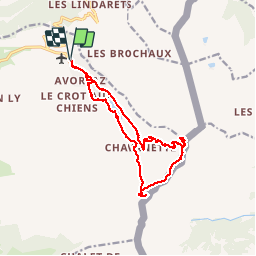
9.6 km | 17.9 km-effort
3h 28min
No
Trail Walking Châtel - Mont de grange depuis le col de Bassachaux  - Photo
Walking
dalla.anthony

Walking

Difficult
(2)
Châtel, Auvergne-Rhône-Alpes, Upper Savoy, France
16.5 km | 30 km-effort
6h 7min
Yes
Trail Walking Morzine - Les Hauts-Forts, Col de l'Encarnette, 2359m - Photo
Walking
tracegps

Walking

Difficult
(2)
Morzine, Auvergne-Rhône-Alpes, Upper Savoy, France
9.1 km | 26 km-effort
7h 30min
Yes
Trail Walking Morzine - Arête de super Morzine - Photo
Walking
labarone

Walking

Medium
Morzine, Auvergne-Rhône-Alpes, Upper Savoy, France
14.7 km | 23 km-effort
5h 2min
No
Trail Walking Montriond - Lac de Montrion, cascade d’Argent - Photo
Walking
daniel34

Walking

Easy
Montriond, Auvergne-Rhône-Alpes, Upper Savoy, France
7.5 km | 10.6 km-effort
1h 57min
Yes
Trail Walking Morzine - 74-Avoriaz-cretes-belvedere-10km-360 - Photo
Walking
SyMA

Walking

Easy
Morzine, Auvergne-Rhône-Alpes, Upper Savoy, France
10 km | 14.9 km-effort
3h 1min
Yes
Trail Walking Morzine - balade des crêtes : Avoriaz . belvédère du lac de Montriond . croix des combes . Avoriaz - Photo
Walking
stef789

Walking

Medium
Morzine, Auvergne-Rhône-Alpes, Upper Savoy, France
9.9 km | 14.8 km-effort
4h 30min
Yes
Trail Walking Abondance - Col de Bassachaux le lac vert 7 juillet 2022 - Photo
Walking
med88

Walking

Very difficult
Abondance, Auvergne-Rhône-Alpes, Upper Savoy, France
13.3 km | 19.9 km-effort
3h 11min
Yes
Trail Walking Morzine - 20170806 Morzine - Photo
Walking
Fabricecha

Walking

Easy
Morzine, Auvergne-Rhône-Alpes, Upper Savoy, France
13.4 km | 19.4 km-effort
3h 54min
No


Close
My subscriptions