![](/images/other/stat-length.png)
![Trail Walking Leuven - GR 128 : Leuven & variante - Photo](https://media.geolcdn.com/t/1900/400/ext.pjpeg?maxdim=2&url=https%3A%2F%2Fstatic1.geolcdn.com%2Fsiteimages%2Fupload%2Ffiles%2F1553511878bg_sport_marche.png)
GR 128 : Leuven & variante
jojolemarcheur
User
![Length](/images/other/stat-length.png)
Length
23 km
![Max alt](https://static1.geolcdn.com/siteimages/upload/files/1508320355ic_sort_altitude_max_24dp.png)
Max alt
100 m
![Uphill gradient](https://static1.geolcdn.com/siteimages/upload/files/1508320355ic_sort_den_pos_24dp.png)
Uphill gradient
243 m
![Km-Effort](/images/other/stat-length.png)
Km-Effort
26 km
![Min alt](https://static1.geolcdn.com/siteimages/upload/files/1508320355ic_sort_altitude_min_24dp.png)
Min alt
15 m
![Downhill gradient](https://static1.geolcdn.com/siteimages/upload/files/1508320355ic_sort_den_neg_24dp.png)
Downhill gradient
244 m
![Boucle](https://static1.geolcdn.com/siteimages/upload/files/16400158638029165_repeat_loop_refresh_sync_direction_icon.png)
Boucle
Yes
Creation date :
2016-07-17 00:00:00.0
Updated on :
2016-07-17 00:00:00.0
![Walking](https://static1.geolcdn.com/sitytour/trail-icons/101.png)
5h42
Difficulty : Easy
![Scan this QR Code to open this trail in the SityTrail application](https://capi.geolives.com/qq0zvz2zws4bq2lad0pu/sitytour/trails/599969/qr.png?size=200)
FREE GPS app for hiking
About
Trail Walking of 23 km to be discovered at Flanders, Flemish Brabant, Leuven. This trail is proposed by jojolemarcheur.
Description
GR 128 : Saint-Omer > Aachen.
Le Domaine Provincial récréatif était fermé lors de la randonnée (ouvert à partir de 09.00 hrs), donc j'ai dû le contourner.
Positioning
Country:
Belgium
Region :
Flanders
Department/Province :
Flemish Brabant
Municipality :
Leuven
Location:
Leuven
Start:(Dec)
Start:(UTM)
620643 ; 5638141 (31U) N.
Comments
Trails nearby
![Trail Walking Leuven - Entre Louvain et Holsbeek - Photo](https://media.geolcdn.com/t/375/260/6144a09e-b9f6-4936-bd2f-90e77722db59.jpeg&format=jpg&maxdim=2)
![Walking Walking](https://static1.geolcdn.com/sitytour/trail-icons/101.png)
Entre Louvain et Holsbeek
Walking
Medium
(2)
Leuven,
Flanders,
Flemish Brabant,
Belgium
![](/images/other/stat-length.png)
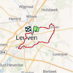
18.1 km | 22 km-effort
5h 1min
![](https://static1.geolcdn.com/siteimages/upload/files/16400158638029165_repeat_loop_refresh_sync_direction_icon.png)
Yes
![Walking Walking](https://static1.geolcdn.com/sitytour/trail-icons/101.png)
20220319 - Un jour à Leuven
Walking
Easy
Leuven,
Flanders,
Flemish Brabant,
Belgium
![](/images/other/stat-length.png)
7.8 km | 8.6 km-effort
5h 49min
![](https://static1.geolcdn.com/siteimages/upload/files/16400158638029165_repeat_loop_refresh_sync_direction_icon.png)
Yes
![Trail On foot Holsbeek - Hagelandse Vallei Blauwe ruit - Photo](https://media.geolcdn.com/t/375/260/584f6b47-ae61-4a88-a68d-8ff488d96db6.jpeg&format=jpg&maxdim=2)
![On foot On foot](https://static1.geolcdn.com/sitytour/trail-icons/100.png)
Hagelandse Vallei Blauwe ruit
On foot
Easy
Holsbeek,
Flanders,
Flemish Brabant,
Belgium
![](/images/other/stat-length.png)
7.1 km | 7.7 km-effort
1h 45min
![](https://static1.geolcdn.com/siteimages/upload/files/16400158638029165_repeat_loop_refresh_sync_direction_icon.png)
Yes
![Trail On foot Bierbeek - Sint-Ermelindiswandelpad - Photo](https://media.geolcdn.com/t/375/260/9625783c-6ca5-421c-8aa7-79681cc715da.jpeg&format=jpg&maxdim=2)
![On foot On foot](https://static1.geolcdn.com/sitytour/trail-icons/100.png)
Sint-Ermelindiswandelpad
On foot
Easy
Bierbeek,
Flanders,
Flemish Brabant,
Belgium
![](/images/other/stat-length.png)
7.6 km | 8.5 km-effort
1h 55min
![](https://static1.geolcdn.com/siteimages/upload/files/16400158638029165_repeat_loop_refresh_sync_direction_icon.png)
Yes
![Trail On foot Leuven - Sint-Kamilluswandelpad - Photo](https://media.geolcdn.com/t/375/260/39142cfb-9828-43ec-bb5d-aea691954c45.jpeg&format=jpg&maxdim=2)
![On foot On foot](https://static1.geolcdn.com/sitytour/trail-icons/100.png)
Sint-Kamilluswandelpad
On foot
Easy
Leuven,
Flanders,
Flemish Brabant,
Belgium
![](/images/other/stat-length.png)
7.5 km | 8.4 km-effort
1h 54min
![](https://static1.geolcdn.com/siteimages/upload/files/16400158638029165_repeat_loop_refresh_sync_direction_icon.png)
Yes
![Trail On foot Lubbeek - Lindenboswandelpad - Photo](https://media.geolcdn.com/t/375/260/ab275fe6-1106-4f9c-b178-e8b6c786ec13.jpeg&format=jpg&maxdim=2)
![On foot On foot](https://static1.geolcdn.com/sitytour/trail-icons/100.png)
Lindenboswandelpad
On foot
Easy
Lubbeek,
Flanders,
Flemish Brabant,
Belgium
![](/images/other/stat-length.png)
10.6 km | 12.6 km-effort
2h 51min
![](https://static1.geolcdn.com/siteimages/upload/files/16400158638029165_repeat_loop_refresh_sync_direction_icon.png)
Yes
![Trail Walking Leuven - Louvain - visite de la ville - Photo](https://media.geolcdn.com/t/375/260/d731f9a7-9412-4d39-87bf-58957d523786.jpg&format=jpg&maxdim=2)
![Walking Walking](https://static1.geolcdn.com/sitytour/trail-icons/101.png)
Louvain - visite de la ville
Walking
Very easy
Leuven,
Flanders,
Flemish Brabant,
Belgium
![](/images/other/stat-length.png)
12.6 km | 14.1 km-effort
2h 59min
![](https://static1.geolcdn.com/siteimages/upload/files/16400158638029165_repeat_loop_refresh_sync_direction_icon.png)
Yes
![Trail Mountain bike Leuven - Bovenlo2Kerkom-short3 - Photo](https://media.geolcdn.com/t/375/260/ext.jpg?maxdim=2&url=https%3A%2F%2Fstatic1.geolcdn.com%2Fsiteimages%2Fupload%2Ffiles%2F1524743154velo.jpg)
![Mountain bike Mountain bike](https://static1.geolcdn.com/sitytour/trail-icons/202.png)
Bovenlo2Kerkom-short3
Mountain bike
Very difficult
(1)
Leuven,
Flanders,
Flemish Brabant,
Belgium
![](/images/other/stat-length.png)
34 km | 40 km-effort
2h 36min
![](https://static1.geolcdn.com/siteimages/upload/files/16400158638029165_repeat_loop_refresh_sync_direction_icon.png)
Yes
![Trail Walking Leuven - w-belgie-bossen-rond-leuven - Photo](https://media.geolcdn.com/t/375/260/ext.jpg?maxdim=2&url=https%3A%2F%2Fstatic1.geolcdn.com%2Fsiteimages%2Fupload%2Ffiles%2F1553511878bg_sport_marche.png)
![Walking Walking](https://static1.geolcdn.com/sitytour/trail-icons/101.png)
w-belgie-bossen-rond-leuven
Walking
Very easy
(1)
Leuven,
Flanders,
Flemish Brabant,
Belgium
![](/images/other/stat-length.png)
12.6 km | 15 km-effort
Unknown
![](https://static1.geolcdn.com/siteimages/upload/files/16400158638029165_repeat_loop_refresh_sync_direction_icon.png)
No