Trail Walking Monaco - Monaco - 2016 06 12 - Photo

Monaco - 2016 06 12

 Orcal37
Orcal37

User GUIDE

© OpenStreetMap contributors
Length
Length
10.2 km
Max alt
Max alt
94 m
Uphill gradient
Uphill gradient
268 m
Km-Effort
Km-Effort  
13.8 km
Min alt
Min alt
0 m
Downhill gradient
Downhill gradient
272 m
Boucle
Boucle
Yes
Creation date :
2016-07-18 00:00:00.0
Updated on :
2021-09-15 14:39:41.948

(0 Reviews)

Walking
Walking
3h10
Difficulty : Easy

Scan this QR Code to open this trail in the SityTrail application

FREE GPS app for hiking

Logo SityTrail SityTrail

IGN / Geographical institutes

Download SityTrail from the App Store Download SityTrail from Google Play

Logo SityTrail SityTrail World

The world is yours!

Download SityTrail from the App Store Download SityTrail from Google Play Download SityTrail on Huawei AppGallery

About

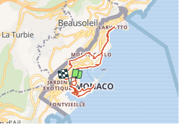
Trail Walking of 10.2 km to be discovered at Unknown, Unknown, Monaco. This trail is proposed by Orcal37.

Description

Monaco - 2016 06 12

Elevation profile

Photos

Positioning

Country:
Monaco
Region :
Unknown
Department/Province :
Unknown
Municipality :
Monaco
Location:
Unknown
Start:(UTM)
372712 ; 4843399 (32T) N.

Trails nearby

Trail Walking Cap-d'Ail - Nice Cap d'Ail en train et retour par les cretes - Photo
Walking
GUIDE
jouans

Walking

Very difficult
Cap-d'Ail, Provence-Alpes-Côte d'Azur, Maritime Alps, France
23 km | 36 km-effort
8h 6min
No
Trail Walking Roquebrune-Cap-Martin - cape martin - Photo
Walking
danpar

Walking

Medium
(2)
Roquebrune-Cap-Martin, Provence-Alpes-Côte d'Azur, Maritime Alps, France
4.4 km | 5.9 km-effort
1h 57min
Yes
Trail Other activity La Turbie - fort de la Revere  - Photo
Other activity
juleyann

Other activity

Very easy
(1)
La Turbie, Provence-Alpes-Côte d'Azur, Maritime Alps, France
8.4 km | 12 km-effort
1h 37min
Yes
Trail Walking Monaco - Monaco - Photo
Walking
GUIDE
Orcal37

Walking

Very easy
Monaco, Unknown, Unknown, Monaco
3.6 km | 4.9 km-effort
55min
Yes
Trail Walking Cap-d'Ail - 06 cap d ail tête de 🐕 01.06.24 - Photo
Walking
GUIDE
randodyssée

Walking

Medium
Cap-d'Ail, Provence-Alpes-Côte d'Azur, Maritime Alps, France
15.3 km | 24 km-effort
6h 55min
Yes
Trail Walking Cap-d'Ail - Cap d’ail - Nice Riquier - Photo
Walking
ETMU5496

Walking

Medium
Cap-d'Ail, Provence-Alpes-Côte d'Azur, Maritime Alps, France
22 km | 35 km-effort
7h 59min
No
Trail Walking Roquebrune-Cap-Martin - Tour du Mont Gros 11.11.22 - Photo
Walking
GUIDE
fredetpascale

Walking

Easy
Roquebrune-Cap-Martin, Provence-Alpes-Côte d'Azur, Maritime Alps, France
4.8 km | 8.2 km-effort
1h 30min
Yes
Trail Walking Èze - Eze - Photo
Walking
GUIDE
jouans

Walking

Very difficult
Èze, Provence-Alpes-Côte d'Azur, Maritime Alps, France
14 km | 26 km-effort
4h 32min
Yes
Trail Walking Cap-d'Ail - La Tête de chien 550m 21.04.22 - Photo
Walking
GUIDE
fredetpascale

Walking

Medium
Cap-d'Ail, Provence-Alpes-Côte d'Azur, Maritime Alps, France
5.2 km | 9.7 km-effort
2h 34min
Yes


Close
My subscriptions