Trail Walking Bourg-de-Sirod - Bourg-de-Sirod 18.2 km - Photo
 cmike39
cmike39

User

© OpenStreetMap contributors
Length
Length
18.2 km
Max alt
Max alt
737 m
Uphill gradient
Uphill gradient
590 m
Km-Effort
Km-Effort  
26 km
Min alt
Min alt
529 m
Downhill gradient
Downhill gradient
590 m
Boucle
Boucle
Yes
Creation date :
2016-10-06 00:00:00.0
Updated on :
2016-10-06 00:00:00.0

(0 Reviews)

Walking
Walking
5h26
Difficulty : Unknown

Scan this QR Code to open this trail in the SityTrail application

FREE GPS app for hiking

Logo SityTrail SityTrail

IGN / Geographical institutes

Download SityTrail from the App Store Download SityTrail from Google Play

Logo SityTrail SityTrail World

The world is yours!

Download SityTrail from the App Store Download SityTrail from Google Play Download SityTrail on Huawei AppGallery

About

Trail Walking of 18.2 km to be discovered at Bourgogne-Franche-Comté, Jura, Bourg-de-Sirod. This trail is proposed by cmike39.

Description

Parcouru le 07/07/2016. RSGD: Richard D.

Elevation profile

Positioning

Country:
France
Region :
Bourgogne-Franche-Comté
Department/Province :
Jura
Municipality :
Bourg-de-Sirod
Location:
Unknown
Start:(UTM)
726195 ; 5179210 (31T) N.

Trails nearby

Trail Walking Nozeroy - Source de l'Ain - Photo
Walking
tracegps

Walking

Medium
(2)
Nozeroy, Bourgogne-Franche-Comté, Jura, France
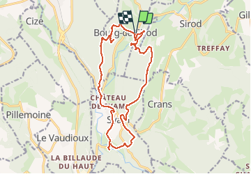
13.4 km | 18.9 km-effort
3h 30min
Yes
Trail Walking Bourg-de-Sirod - Perte de l'Ain 15.7.24 - Photo
Walking
GUIDE
fredetpascale

Walking

Easy
Bourg-de-Sirod, Bourgogne-Franche-Comté, Jura, France
3.3 km | 4.9 km-effort
1h 15min
Yes
Trail Walking Nozeroy - Source de l'Ain 15.7.24 - Photo
Walking
GUIDE
fredetpascale

Walking

Easy
Nozeroy, Bourgogne-Franche-Comté, Jura, France
6.1 km | 8.5 km-effort
2h 0min
No
Trail Walking Nozeroy - Nozeroy la source de l'Ain  - Photo
Walking
grasgilbert

Walking

Difficult
(1)
Nozeroy, Bourgogne-Franche-Comté, Jura, France
10.8 km | 15.1 km-effort
3h 26min
Yes
Trail On foot Pillemoine - GR - Photo
On foot
GUIDE+

On foot

Easy
Pillemoine, Bourgogne-Franche-Comté, Jura, France
9.3 km | 12.9 km-effort
2h 55min
No
Trail Walking Conte - roro - Photo
Walking
chantal40

Walking

Medium
Conte, Bourgogne-Franche-Comté, Jura, France
11 km | 15.4 km-effort
6h 33min
Yes
Trail Walking Lent - roro - Photo
Walking
chantal40

Walking

Medium
Lent, Bourgogne-Franche-Comté, Jura, France
11.5 km | 17.3 km-effort
7h 30min
Yes
Trail Walking Conte - Source de l'Ain - Photo
Walking
Marie-Claire-mcp

Walking

Very easy
Conte, Bourgogne-Franche-Comté, Jura, France
4.4 km | 6.1 km-effort
1h 43min
No
Trail Walking Syam - Cascade de la Billaude - Photo
Walking
Alexandre1980

Walking

Very difficult
(1)
Syam, Bourgogne-Franche-Comté, Jura, France
15.3 km | 22 km-effort
4h 54min
Yes


Close
My subscriptions